Holzbunge
| coat of arms | Germany map | |
|---|---|---|

|
Coordinates: 54 ° 23 ' N , 9 ° 43' E |
|
| Basic data | ||
| State : | Schleswig-Holstein | |
| Circle : | Rendsburg-Eckernförde | |
| Office : | Hüttener Mountains | |
| Height : | 19 m above sea level NHN | |
| Area : | 5.19 km 2 | |
| Residents: | 343 (Dec. 31, 2019) | |
| Population density : | 66 inhabitants per km 2 | |
| Postal code : | 24361 | |
| Area code : | 04356 | |
| License plate : | RD, ECK | |
| Community key : | 01 0 58 081 | |
| Office administration address: | Mühlenstrasse 8 24361 Groß Wittensee |
|
| Website : | ||
| Mayor : | Ole Bening (KWH) | |
| Location of the municipality of Holzbunge in the Rendsburg-Eckernförde district | ||
Holzbunge (Danish Holtbunge ) is a municipality in the district of Rendsburg-Eckernförde in Schleswig-Holstein . Freudental, Sande, Ziegelei and Exklave Stenten are located in the municipality.
Geography and traffic
Holzbunge is located on the edge of the Hüttener Mountains about 7 km northeast of Rendsburg west of the Wittensee on the federal road 203 from Rendsburg to Eckernförde . The A7 / E45 runs to the west from Rendsburg to Schleswig . The next motorway exit is Büdelsdorf / Eckernförde.
politics
Community representation
The Wählergemeinschaft KWH has since the local elections of 2003, all nine seats in the municipal council.
coat of arms
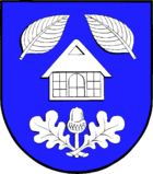
Blazon : "In blue under two inwardly inclined silver beech leaves and above two silver oak leaves that cross with the stems and enclose a stalked acorn, a gable silver half-timbered cottage."
economy
The community is dominated by agriculture and small businesses.
Attractions
The list of cultural monuments in Holzbunge includes the cultural monuments entered in the list of monuments of Schleswig-Holstein.
Web links
Individual evidence
- ↑ North Statistics Office - Population of the municipalities in Schleswig-Holstein 4th quarter 2019 (XLSX file) (update based on the 2011 census) ( help on this ).
- ↑ Schleswig-Holstein topography. Vol. 5: Holt - Krokau . 1st edition Flying-Kiwi-Verl. Junge, Flensburg 2005, ISBN 978-3-926055-79-8 , pp. 8 ( dnb.de [accessed on July 18, 2020]).
- ↑ Schleswig-Holstein's municipal coat of arms

