Gnutz
| coat of arms | Germany map | |
|---|---|---|

|
Coordinates: 54 ° 8 ' N , 9 ° 49' E |
|
| Basic data | ||
| State : | Schleswig-Holstein | |
| Circle : | Rendsburg-Eckernförde | |
| Office : | Nortorfer Land | |
| Height : | 24 m above sea level NHN | |
| Area : | 22.93 km 2 | |
| Residents: | 1175 (Dec. 31, 2019) | |
| Population density : | 51 inhabitants per km 2 | |
| Postal code : | 24622 | |
| Area code : | 04392 | |
| License plate : | RD, ECK | |
| Community key : | 01 0 58 059 | |
| Office administration address: | Niedernstrasse 6 24646 Nortorf |
|
| Website : | ||
| Mayor : | Markus Mehrens | |
| Location of the community Gnutz in the Rendsburg-Eckernförde district | ||
Gnutz is a municipality in the Rendsburg-Eckernförde district in Schleswig-Holstein . Hofkamp and Viert are in the municipality.
Geography and traffic
Gnutz is about twelve kilometers northwest of Neumünster on the edge of the Aukrug Nature Park . The federal highway 205 , the federal highway 7 and the railway line from Rendsburg to Neumünster run to the east, the federal highway 430 to the south .
history
The community was first mentioned as Gnuttese in 1320. It is believed that the name refers to a lake, but it no longer exists today. The name also suggests that it is a Slavic local foundation.
In the 16th century there was a royal sheep farm in Gnutz.
politics
Community representation
Since the 2008 local elections, the KWG electoral community has held all eleven seats in the municipal council.
coat of arms
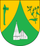
Blazon : "A curved green tip in gold, inside a silver church, accompanied at the front by an upright prehistoric green battle ax, at the back by a green buckwheat branch with flowers."
economy
The community is predominantly agricultural, but there are also several businesses and two tree nurseries. Tobacco has been grown in Gnutz since the end of the Second World War .
Attractions
To the southwest of the village there is a newly created Celtic tree circle (coordinates: 54 ° 7 ′ 3.3 ″ N , 9 ° 48 ′ 13.6 ″ E ).
literature
- Jürgen Kleen: From the past for the present - village chronicle of the Gnutz community, 1938
- Erwin Fritschka and Siegfried Geiger: Chronik Gnutz, self-published, 1998
- Puttkamer, Karl von: Old Gnutzer Houses tell, self-published, 2008
Web links
Individual evidence
- ↑ North Statistics Office - Population of the municipalities in Schleswig-Holstein 4th quarter 2019 (XLSX file) (update based on the 2011 census) ( help on this ).
- ↑ Schleswig-Holstein's municipal coat of arms


