Schulldorf
| coat of arms | Germany map | |
|---|---|---|

|
Coordinates: 54 ° 18 ' N , 9 ° 44' E |
|
| Basic data | ||
| State : | Schleswig-Holstein | |
| Circle : | Rendsburg-Eckernförde | |
| Office : | Eider Canal | |
| Height : | 10 m above sea level NHN | |
| Area : | 12.99 km 2 | |
| Residents: | 747 (Dec. 31, 2019) | |
| Population density : | 58 inhabitants per km 2 | |
| Postal code : | 24790 | |
| Area code : | 04331 | |
| License plate : | RD, ECK | |
| Community key : | 01 0 58 146 | |
| Office administration address: | Schulstrasse 36 24783 Osterrönfeld |
|
| Website : | ||
| Mayor : | Siegfried Tomkowiak | |
| Location of the community of Schülldorf in the Rendsburg-Eckernförde district | ||
Schülldorf is a municipality on the Schülldorfer See in the Rendsburg-Eckernförde district in Schleswig-Holstein . Ohe is located in the municipality that has existed in its current form since 1939.
Geography and traffic
The Schülldorf stop is on the Husum – Kiel railway line . Regional trains stop every hour. Schülldorf is located directly southeast of Rendsburg between the Kiel Canal , the federal highway 7 from Hamburg to Rendsburg and the federal highway 210 from Rendsburg to Kiel .
history
The dolmen of Schülldorf indicates pre-Christian settlement.
politics
Community representation
Of the nine seats in the municipal council, the KWS community of voters has four seats since the 2013 local elections, the NFLS community of voters has three and the ASW community of voters has two.
coat of arms
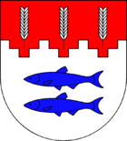
Blazon : “Divided by red and silver in a ratio of 1: 2 in a stepped gable shape (two steps). Above three ears of silver next to each other; below two blue fish on top of each other. "
economy
The municipality is predominantly agricultural.
Web links
Individual evidence
- ↑ North Statistics Office - Population of the municipalities in Schleswig-Holstein 4th quarter 2019 (XLSX file) (update based on the 2011 census) ( help on this ).
- ↑ Schleswig-Holstein topography. Vol. 9: Schönberg - Tielenhemme . 1st edition Flying-Kiwi-Verl. Junge, Flensburg 2007, ISBN 978-3-926055-91-0 , p. 30 ( dnb.de [accessed July 30, 2020]).
- ↑ Five new stations between Rendsburg and Kiel are opened
- ↑ Schleswig-Holstein's municipal coat of arms


