Noer
| coat of arms | Germany map | |
|---|---|---|

|
Coordinates: 54 ° 28 ' N , 10 ° 0' E |
|
| Basic data | ||
| State : | Schleswig-Holstein | |
| Circle : | Rendsburg-Eckernförde | |
| Office : | Dänischenhagen | |
| Height : | 29 m above sea level NHN | |
| Area : | 13.9 km 2 | |
| Residents: | 870 (Dec. 31, 2019) | |
| Population density : | 63 inhabitants per km 2 | |
| Postal code : | 24214 | |
| Area code : | 04346 | |
| License plate : | RD, ECK | |
| Community key : | 01 0 58 116 | |
| Office administration address: | Sturenhagener Weg 14 24229 Dänischenhagen |
|
| Website : | ||
| Mayoress : | Sabine Mues ( CDU ) | |
| Location of the municipality of Noer in the Rendsburg-Eckernförde district | ||
Noer ( Danish : Nør ) is a municipality in the district of Rendsburg-Eckernförde in Schleswig-Holstein . It consists of the two districts of Noer and Lindhöft.
Geography and traffic
Noer is located about 12 km east of Eckernförde on the Eckernförde Bay of the Baltic Sea . The L 285, coastal stretch from Eckernförde towards Kiel, runs through the village. The L 285 becomes the federal highway 503 at Sprenge .
history
The place name is first documented in writing in 1479 (Rep. Dipl.). There are the forms tor Noer and tor Nore . The name may describe a slope or a steep coast (cf. Westphalian Nörre ). An interpretation to the north is also possible . nor for a noor .
politics
Community representation
Of the eleven seats in the municipal council, the CDU received ten seats and one individual applicant one seat in the 2018 local elections.
coat of arms
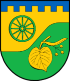
Blazon : “Under a pinned blue shield head divided by gold and green by a rounded left bevel. Above a wagon wheel with twelve spokes, below a fallen linden leaf with an inflorescence in mixed up colors. "
recreation
On the territory of the municipality there is, among other things, the nature reserve wooded dune near Noer , which is part of the European ecological network Natura 2000 . The area is under protection because all stages of dune development from the flushing border zone to the forest can be found here in a very small space.
Attractions
Cultural monuments
The list of cultural monuments in Noer includes the cultural monuments entered in the list of monuments of Schleswig-Holstein.
Noer Castle and Lindhöft Estate
The village of Noer is first mentioned in a document in 1317. The Good Noer is probably the knights of Ahlefeld was founded in the 15th century. It was owned by this family for two centuries from around 1414 to 1610. The von Rantzau family owned the estate from 1610 to 1675 . In 1680 it went to the von Brockdorff family . Wulf von Brockdorff (1651–1732) from the Wensin family had the castle-like mansion built from 1708–1711.
His son Joachim von Brockdorff (1695–1763) had the new church built in Krusendorf from 1733–1737 . The burial chapel for the von Brockdorff family is located in the entrance hall of this church. In sarcophagi of marble there are Joachim von Brockdorff and his wife, Friederike Louise Countess of Holstein . In 1763 Adam Gottlob von Moltke inherited Castle and Gut Noer. It remained in the family until his grandson Adam Gottlob Detlev von Moltke decided to sell it in 1801. Bernhard von Qualen (1758–1831) became the new owner . In 1832 the Duchess of Schleswig-Holstein-Sonderburg-Augustenburg bought Noer and the neighboring Grönwohld estate for her son. He took the name Prince von Noer. The Prince of Noer Friedrich Emil August von Schleswig-Holstein-Sonderburg-Augustenburg was a leader in the uprising against the Danish royal family in 1848. As Minister of War of the Provisional Government , he did not wait for the delegation to return from Copenhagen and took the Rendsburg fortress by surprise with his subordinate troop , which started the Schleswig-Holstein War (1848-1851) . After the collapse of the Schleswig-Holstein uprising , the prince had to give up his property and go into exile. In 1864 he was appointed Prince von Noer by the Austrian Emperor. He and his first wife are buried in Krusendorf.
The castle burned down in 1933, but was rebuilt in its old form. After the Second World War the estate was relocated. The manor house was acquired by the Schleswig-Holstein Society for Youth Care Facilities and has been used as a youth education and meeting place since 1961. Together with the inspector's house and the converted riding stables, it has 143 beds and is popular with choirs and orchestras because of its acoustics.
The Grönwohld estate was bequeathed to the German hunters as early as 1938. The associated forest is now a training area for the training of hunters.
Gut Lindhof, now an experimental farm of the Christian-Albrechts-Universität zu Kiel , is located in the municipality.
Web links
Individual evidence
- ↑ North Statistics Office - Population of the municipalities in Schleswig-Holstein 4th quarter 2019 (XLSX file) (update based on the 2011 census) ( help on this ).
- ↑ Schleswig-Holstein topography. Vol. 7: Munkbrarup - Pohnsdorf . 1st edition Flying-Kiwi-Verl. Junge, Flensburg 2006, ISBN 978-3-926055-88-0 , p. 133 ( dnb.de [accessed on July 22, 2020]).
- ↑ Wolfgang Laur: Historisches Ortsnamelexikon von Schleswig-Holstein , 2nd edition, Neumünster 1992, p. 484
- ↑ Johannes Kok: Det Danske folkesprog i Sønderjylland , Volume 2, Copenhagen 1867, p. 291
- ↑ Schleswig-Holstein's municipal coat of arms
- ↑ Marcus Köhler: History of the Noer Estate - The last years of the prince , page 4-6


