Hoffeld (Holstein)
| coat of arms | Germany map | |
|---|---|---|

|
Coordinates: 54 ° 11 ′ N , 9 ° 59 ′ E |
|
| Basic data | ||
| State : | Schleswig-Holstein | |
| Circle : | Rendsburg-Eckernförde | |
| Office : | Bordesholm | |
| Height : | 37 m above sea level NHN | |
| Area : | 6.62 km 2 | |
| Residents: | 161 (Dec. 31, 2019) | |
| Population density : | 24 inhabitants per km 2 | |
| Postal code : | 24582 | |
| Area code : | 04322 | |
| License plate : | RD, ECK | |
| Community key : | 01 0 58 076 | |
| Office administration address: | Mühlenstrasse 7 24582 Bordesholm |
|
| Website : | ||
| Mayor : | Sönke Harder | |
| Location of the municipality Hoffeld in the Rendsburg-Eckernförde district | ||
Hoffeld is a municipality in the Rendsburg-Eckernförde district in Schleswig-Holstein . Ruhleben, Eichenhof, Hochfeld, Poggenhörn, Kirschenhof, Stanhagen, Hunnshörn, Ochsenweide, Am Kalberg, Kielsland, Ziegelhof, Nollenkamp, Das Schloss, Am Waldbach, Brüninghof, Krabbendiek, Lindenhof, Eckhof, Wehwarder, An de Straat, Asbahrenwisch, Suhrendorf and Uns Dörphuus are located in the municipality.
Geography and traffic
Hoffeld is a scattered settlement with large forests about 11 km north of Neumünster and 15 km south of Kiel between the federal motorway 215 and the former federal highway 4 .
politics
Community representation
Of the seven seats in the municipal council, the KWG has had all seats since the local elections in 2003.
coat of arms
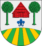
Blazon : “Slightly arched, subdivided. Above, in silver over a blue lily, a red Bordesholmer farmhouse between two green deciduous trees, below, eight times overturned and split in a fan shape by green and gold. "
economy
The municipality is predominantly agricultural.
Attractions
The list of cultural monuments in Hoffeld (Holstein) includes the cultural monuments entered in the list of monuments of Schleswig-Holstein.
Personalities
- Hans Heinrich Brüning (1848–1928), German ethnographer and linguist
- Rolf Winter (1927–2005), German journalist and non-fiction author
Web links
swell
- ↑ North Statistics Office - Population of the municipalities in Schleswig-Holstein 4th quarter 2019 (XLSX file) (update based on the 2011 census) ( help on this ).
- ↑ Schleswig-Holstein topography. Vol. 4: Groß Sarau - Holstenniendorf . 1st edition Flying-Kiwi-Verl. Junge, Flensburg 2004, ISBN 978-3-926055-75-0 , p. 292 ( dnb.de [accessed on May 3, 2020]).
- ↑ Schleswig-Holstein's municipal coat of arms

