Bargstedt (Holstein)
| coat of arms | Germany map | |
|---|---|---|

|
Coordinates: 54 ° 10 ' N , 9 ° 46' E |
|
| Basic data | ||
| State : | Schleswig-Holstein | |
| Circle : | Rendsburg-Eckernförde | |
| Office : | Nortorfer Land | |
| Height : | 26 m above sea level NHN | |
| Area : | 25.32 km 2 | |
| Residents: | 718 (Dec. 31, 2019) | |
| Population density : | 28 inhabitants per km 2 | |
| Postal code : | 24793 | |
| Primaries : | 04875, 04392 | |
| License plate : | RD, ECK | |
| Community key : | 01 0 58 011 | |
| Office administration address: | Niedernstrasse 6 24646 Nortorf |
|
| Website : | ||
| Mayor : | Robert Struck (KWG) | |
| Location of the municipality of Bargstedt in the Rendsburg-Eckernförde district | ||
Bargstedt is a municipality belonging to the Nortorfer Land district in the Rendsburg-Eckernförde district in Schleswig-Holstein . Holtdorf and the extensions Bast, Föhrenskamp and Bargstedter Moor are in the municipality.
geography
Bargstedt is located in the Aukrug Nature Park . The community is connected to the supra-regional transport network via the federal road 205 , the state road 125 and the district road 66, which runs along the eastern edge of the district .
history
Bargstedt was first mentioned in a document in 1442.
Incorporations
On January 1, 1978, the previously independent municipality of Holtdorf joined the municipality of Bargstedt.
politics
Community representation
Of the eleven seats in the municipal council has Wählergemeinschaft KWG since the local elections in 2013 eight seats and the voter community FWG three.
coat of arms
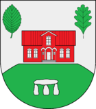
Blazon : "In silver, a green hill flattened at the top, inside a stone grave consisting of three supporting stones and a cover plate, above a floating red house, accompanied on the right by a green beech leaf and on the left by a green oak leaf."
flag
Blazon : "The figures of the municipal coat of arms in tincture appropriate for the flag on a white flag cloth."
education
There is a primary school in the community, which also accepts pupils from the neighboring communities of Brammer and Oldenhütten . A community school with an upper level is located in Nortorf , grammar schools and other secondary schools in Rendsburg . In the primary school building there is also the municipal kindergarten with currently 40 places, in which the children of the two neighboring municipalities are also admitted.
Web links
Individual evidence
- ↑ North Statistics Office - Population of the municipalities in Schleswig-Holstein 4th quarter 2019 (XLSX file) (update based on the 2011 census) ( help on this ).
- ↑ Aasbüttel - Bordesholm . In: Wolfgang Henze (ed.): Schleswig-Holstein topography: cities and villages of the country . 1st edition. tape 1 . Flying-Kiwi-Verl. Junge, Flensburg 2001, ISBN 3-926055-58-8 , p. 195 .
- ^ Federal Statistical Office (ed.): Historical municipality directory for the Federal Republic of Germany. Name, border and key number changes in municipalities, counties and administrative districts from May 27, 1970 to December 31, 1982 . W. Kohlhammer GmbH, Stuttgart / Mainz 1983, ISBN 3-17-003263-1 , p. 184 .
- ↑ Results of the 2013 local elections
- ↑ a b Schleswig-Holstein's municipal coat of arms

