Bornholt
| coat of arms | Germany map | |
|---|---|---|

|
Coordinates: 54 ° 6 ′ N , 9 ° 20 ′ E |
|
| Basic data | ||
| State : | Schleswig-Holstein | |
| Circle : | Rendsburg-Eckernförde | |
| Office : | Mittelholstein | |
| Height : | 21 m above sea level NHN | |
| Area : | 10.94 km 2 | |
| Residents: | 167 (Dec. 31, 2019) | |
| Population density : | 15 inhabitants per km 2 | |
| Postcodes : | 25557, 25725 | |
| Area code : | 04872 | |
| License plate : | RD, ECK | |
| Community key : | 01 0 58 025 | |
| LOCODE : | DE 92B | |
| Office administration address: | Am Markt 15 24594 Hohenwestedt |
|
| Website : | ||
| Mayor : | Thorsten Martens (KWG) | |
| Location of the Bornholt community in the Rendsburg-Eckernförde district | ||
Bornholt is a municipality in the Rendsburg-Eckernförde district in Schleswig-Holstein . Großenbornholt, Lütjenbornholt and Töpferberg are in the municipality.
Geography and traffic
Bornholt is located directly east of the federal highway 23 from Hamburg to Heide on the Kiel Canal , which divides the community. The Hohenhörn high bridge is located in the municipality.
In the course of the motorway expansion, a landscape protection area was created in Lütjenbornholt .
history
It was first mentioned in a document in 1447. The name means something like "wood at the source". Here “Born” stands for “source” and “Holt” for “wood”.
politics
Community representation
Of the nine seats in the municipal council after the 2008 local elections, the KWG electoral community won all seats, as did the seven seats after the 2013 local elections and after the 2018 local elections.
coat of arms
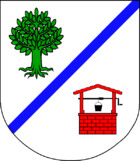
Blazon : "In silver an oblique left blue bar, above a green deciduous tree, below a red roofed fountain with a black bucket on the black crank."
economy
Tourism is an important source of income for the community.
Web links
Individual evidence
- ↑ North Statistics Office - Population of the municipalities in Schleswig-Holstein 4th quarter 2019 (XLSX file) (update based on the 2011 census) ( help on this ).
- ↑ Schleswig-Holstein topography. Vol. 2: Boren - Ellerau . 1st edition Flying-Kiwi-Verl. Junge, Flensburg 2002, ISBN 978-3-926055-68-2 , p. 21 ( dnb.de [accessed June 11, 2020]).
- ↑ Schleswig-Holstein topography. Vol. 2: Boren - Ellerau . 1st edition Flying-Kiwi-Verl. Junge, Flensburg 2002, ISBN 978-3-926055-68-2 , p. 21 ( dnb.de [accessed June 12, 2020]).
- ^ Result of municipal elections 2013 ( Memento from December 20, 2013 in the Internet Archive )
- ↑ Bornholt municipal election 2018 constituency 06/1 - Bornholt. Mittelholstein Office, accessed on September 3, 2018 .
- ↑ Schleswig-Holstein's municipal coat of arms

