
Steenfeld
| coat of arms | Germany map | |
|---|---|---|

|
Coordinates: 54 ° 9 ' N , 9 ° 23' E |
|
| Basic data | ||
| State : | Schleswig-Holstein | |
| Circle : | Rendsburg-Eckernförde | |
| Office : | Mittelholstein | |
| Height : | 19 m above sea level NHN | |
| Area : | 11.48 km 2 | |
| Residents: | 334 (Dec. 31, 2019) | |
| Population density : | 29 inhabitants per km 2 | |
| Postal code : | 25557 | |
| Area code : | 04872 | |
| License plate : | RD, ECK | |
| Community key : | 01 0 58 156 | |
| Office administration address: | Am Markt 15 24594 Hohenwestedt |
|
| Website : | ||
| Mayor : | Ralf Eichert (USHB) | |
| Location of the municipality of Steenfeld in the Rendsburg-Eckernförde district | ||
 |
||

Steenfeld is a municipality in the Rendsburg-Eckernförde district in Schleswig-Holstein . Fischerhütte, Liesbüttel, Pemeln, Spann, Schnittlohe and Wilhelmsburg are in the municipality.
Geography and traffic
The community is located about 18 km southeast of Heide on Geesthügeln on the Gieselau on the Kiel Canal . The pier for the Fischerhütte canal ferry is in the municipality. The last chain ferry has been exhibited as a technical monument since 1992. The surrounding area is largely rural, but the larger cities can be easily reached via the nearby motorway connection. A school and kindergartens are located not far in the next town Hanerau-Hademarschen.
politics
Community representation
Of the nine seats in the municipal council, the CDU has four and the USHB electoral community five since the 2013 local elections.
coat of arms
Blazon : "Under a silver shield head, divided by a blue bar, inside three green field stones, of silver and green tipped ten times and split in a fan shape."
economy
Tourism is an important source of income for the municipality. The pony farms in Steenfeld are a popular holiday destination.
Others
The comprehensive expansion of the fiber optic network is planned for Steenfeld.
photos

Memorial stone

"Fischerhütte" ferry terminal
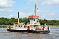
Canal ferry "Pillau"

Old chain ferry


Web links
Individual evidence
- ↑ North Statistics Office - Population of the municipalities in Schleswig-Holstein 4th quarter 2019 (XLSX file) (update based on the 2011 census) ( help on this ).
- ↑ a b Schleswig-Holstein topography. Vol. 9: Schönberg - Tielenhemme . 1st edition Flying-Kiwi-Verl. Junge, Flensburg 2007, ISBN 978-3-926055-91-0 , p. 184 ( dnb.de [accessed on August 5, 2020]).
- ↑ Allocation of seats after the 2013 municipal elections ( memento of the original from December 20, 2013 in the Internet Archive ) Info: The archive link was automatically inserted and not yet checked. Please check the original and archive link according to the instructions and then remove this notice.
- ↑ Schleswig-Holstein's municipal coat of arms
Backguard | Ahlefeld-Bistensee | Alt Duvenstedt | Altenhof | Altenholz | Arpsdorf | Cinderella | Aukrug | Bargstall | Bargstedt | Barkelsby | Beldorf | Bendorf | Beringstedt | Bite | Blumenthal | Böhnhusen | Bokel | Bordesholm | Borgdorf-Seedorf | Borgstedt | Bornholt | Bovenau | Brammer | Bredenbek | Pulpwood | Brekendorf | Brinjahe | Brodersby | Bruges | Büdelsdorf | Bünsdorf | Christiansholm | Damendorf | Damp | Dänischenhagen | Dätgen | Dörphof | Eckernförde | Ehndorf | Eisendorf | Ellerdorf | Elsdorf-Westermühlen | Embühren | Emkendorf | Field | Felm | Fleckeby | Flintbek | Fockbek | Friedrichsgraben | Friedrichsholm | Gammelby | Gettorf | Gnutz | Gokels | Goosefeld | Grauel | Grevenkrug | Groß Buchwald | Groß Vollstedt | Groß Wittensee | Güby | Haale | Haby | Hamdorf | Hamweddel | Hanerau-Hademarschen | Hassmoor | Heinkenborstel | Hofeld | Hohenwestedt | Scorn | Holtsee | Holzbunge | Holzdorf | Hearst | Hummelfeld | Huts | Year village | Jevenstedt | Karby | Klein Wittensee | King's Hill | Kosel | Crogaspe | Kronshagen | Curvilinear | Long tail | Lindau | Lohe-Föhrden | Loop | Loose | Luhnstedt | Lütjenwestedt | Meezen | Melsdorf | Mielkendorf | Molfsee | Mörel | Mühbrook | Negenharry | Neudorf-Bornstein | New Duvenstedt | Neuwittenbek | Nienborstel | Nindorf | Noer | Nortorf | Nübbel | Oldenbüttel | Oldenhütten | Osdorf | Ostenfeld (Rendsburg) | Osterby | Osterrönfeld | Osterstedt | Ottendorf | Owschlag | Padenstedt | Prince's Moor | Quarnbek | Rade b. Hohenwestedt | Rade b. Rendsburg | Reesdorf | Remmels | Rendsburg | Rickert | Rieseby | Rodenbek | Rumohr | Schacht-Audorf | Schierensee | Schinkel | Schmalstede | Schönbek | Schönhorst | Schülldorf | Schülp b. Nortorf | Schülp b. Rendsburg | Schwedeneck | Seefeld | Sehestedt | Sophienhamm | Sören | Stafstedt | Steenfeld | Beaches | Tackesdorf | Tappendorf | Techelsdorf | Thaden | Thumby | Timmaspe | Todenbüttel | Tüttendorf | Waabs | Wapelfeld | Warder | Wasbek | Wattenbek | Westensee | Westerrönfeld | Windeby | Winnemark