Arpsdorf
| coat of arms | Germany map | |
|---|---|---|

|
Coordinates: 54 ° 2 ′ N , 9 ° 52 ′ E |
|
| Basic data | ||
| State : | Schleswig-Holstein | |
| Circle : | Rendsburg-Eckernförde | |
| Office : | Mittelholstein | |
| Height : | 12 m above sea level NHN | |
| Area : | 12.1 km 2 | |
| Residents: | 276 (Dec. 31, 2019) | |
| Population density : | 23 inhabitants per km 2 | |
| Postal code : | 24634 | |
| Area code : | 04324 | |
| License plate : | RD, ECK | |
| Community key : | 01 0 58 007 | |
| LOCODE : | DE 4AW | |
| Office administration address: | Am Markt 15 24594 Hohenwestedt |
|
| Website : | ||
| Mayor : | Jens Krügel (KWG) | |
| Location of the municipality of Arpsdorf in the Rendsburg-Eckernförde district | ||
Arpsdorf is a municipality in the Rendsburg-Eckernförde district in Schleswig-Holstein . In addition to Arpsdorf, the Bahnhofstrasse settlement is also located in the municipality.
Geography and traffic
Arpsdorf is located on the edge of the Aukrug nature park, about 8 km southwest of Neumünster an der Stör . The federal highway 7 runs to the east from Hamburg to Flensburg , to the north the federal highway 430 runs from Neumünster in the direction of Meldorf . Arpsdorf is on the Hamburg-Altona-Kiel railway line . The station there has since been closed. The first official climate forest was created in spring 2012 by the Climate Forest Foundation on the so-called Ohlenkamp (western municipal area, towards Willenscharen ) .
history
The place was first mentioned in 1199 as Erpesthorp. Goods were shipped via the Stör and reloaded onto horse-drawn vehicles in Arpsdorf .
politics
Community representation
Of the nine seats that has Wählergemeinschaft KWG since the local elections in May 2013, all seats in the municipal council.
coat of arms
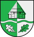
Blazon : “Split by green and silver. In interchanged colors above - covering the split line - the gable front of a rural half-timbered house with boarded gable, below under a wavy beam two outwardly turned oak leaves. "
economy
The municipality is predominantly agricultural. On the western edge of Arpsdorf are the masts of the DLF transmitter Neumünster .
Web links
Individual evidence
- ↑ North Statistics Office - Population of the municipalities in Schleswig-Holstein 4th quarter 2019 (XLSX file) (update based on the 2011 census) ( help on this ).
- ↑ Aasbüttel - Bordesholm . In: Wolfgang Henze (ed.): Schleswig-Holstein topography: cities and villages of the country . 1st edition. tape 1 . Flying-Kiwi-Verl. Junge, Flensburg 2001, ISBN 3-926055-58-8 , p. 107 .
- ↑ Results of the local elections 2013 . amt-mittelholstein.de. Retrieved May 27, 2013.
- ↑ Schleswig-Holstein's municipal coat of arms
- ↑ AM transmitter Neumünster / Ehndorfer Moor

