
Windeby
| coat of arms | Germany map | |
|---|---|---|

|
Coordinates: 54 ° 28 ' N , 9 ° 47' E |
|
| Basic data | ||
| State : | Schleswig-Holstein | |
| Circle : | Rendsburg-Eckernförde | |
| Office : | Schlei Baltic Sea | |
| Height : | 10 m above sea level NHN | |
| Area : | 14.77 km 2 | |
| Residents: | 1019 (Dec. 31, 2019) | |
| Population density : | 69 inhabitants per km 2 | |
| Postal code : | 24340 | |
| Area code : | 04351 | |
| License plate : | RD, ECK | |
| Community key : | 01 0 58 173 | |
| LOCODE : | DE WB5 | |
| Office administration address: | Holm 13 24340 Eckernförde |
|
| Website : | ||
| Mayor : | Peter Pietrzak ( SPD ) | |
| Location of the municipality of Windeby in the Rendsburg-Eckernförde district | ||
 |
||

Windeby ( Danish Vindeby , Low German : Winneby ) is a municipality in the district of Rendsburg-Eckernförde in Schleswig-Holstein .
Geography and traffic
The municipality of Windeby is located west of Eckernförde on the Windebyer Noor . In the north the community borders on federal highway 76 , in the south it is on federal highway 203 from Eckernförde in the direction of Rendsburg . The town of Windeby, which gives the municipality its name, together with the Windeby estate is located southwest of the Windebyer Noors . The capital of the municipality but Kochendorf ( Low German : Kochendörp , Kockendörp , Danish : Kokkentorp ) in the northern municipality.
The districts Friedland, Friedensthal, Christianshöh, Frohsein, Westerthal and Friedenshorst also belong to the community.
history
Origin of name
The ending -by still means “city”, “place” in Danish and “village, settlement” in Jutian and is widespread in the Schleswig area. According to Wolfgang Laur, wind comes from the old Danish "windir" = turn (Slav), so Windeby means nothing else than "Wendendorf".
archeology
The place gained national fame through the discovery of two bog bodies , one of which was known until recently as the girl from Windeby and, according to the latest research, turned out to be a boy. The other bog body is called the Windeby Man . The Osterwall (also: Ostwall ) of the Danewerk runs through the middle of the Windeby capital Kochendorf .
West of Windeby is a Neolithic large stone grave , another large stone grave near Kochendorf has been destroyed. There are several burial mounds near Kochendorf and Friedland .
politics
Community representation
Of the eleven seats in the municipal council had SPD since the municipal election 2003, five seats, the CDU and the voter community FWGW had three each.
Of the eleven seats in the municipal council, the SPD and the FWGW electoral community each had four seats since the 2008 local elections, while the CDU had three. The seating remained unchanged after the 2013 local elections. In this election, the CDU mayor Jutta Werner was replaced by Peter Pietrzak (SPD).
coat of arms
Blazon : "In blue a narrow golden oblique left-hand bar, above a rising golden wolf turned left, below a golden wagon wheel with five spokes."
Attractions
In the list of cultural monuments in Windeby are the cultural monuments entered in the monuments list of the state of Schleswig-Holstein.
Personalities
- Friedrich Christian Boock (1767–1829), Danish lawyer and landowner
photos
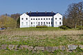
Windeby Manor

Listed remains of the Easter wall of the Danewerk in Kochendorf
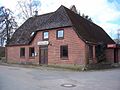
Former Gasthof Mohr in Kochendorf

Kochendorf fire station
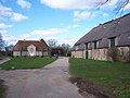
Westerthal manor house


Web links
Individual evidence
- ↑ North Statistics Office - Population of the municipalities in Schleswig-Holstein 4th quarter 2019 (XLSX file) (update based on the 2011 census) ( help on this ).
- ↑ a b c d e Schleswig-Holstein topography. Vol. 10: Timmaspe - Ziethen . 1st edition Flying-Kiwi-Verl. Junge, Flensburg 2008, ISBN 978-3-926055-92-7 , p. 305 ( dnb.de [accessed on August 9, 2020]).
- ↑ see: Irmgard Busch in an article on Osterwall in Rund ums Windebyer Noor (publication by SPD Windeby) December 2008 Page no longer available , search in web archives: online
- ↑ Schleswig-Holstein's municipal coat of arms
literature
- Deert Lafrenz: Manors and manors in Schleswig-Holstein, Windeby pp. 621 - 624. 2nd edition Petersberg 2015, ISBN 978-3-86568-971-9
Backguard | Ahlefeld-Bistensee | Alt Duvenstedt | Altenhof | Altenholz | Arpsdorf | Cinderella | Aukrug | Bargstall | Bargstedt | Barkelsby | Beldorf | Bendorf | Beringstedt | Bite | Blumenthal | Böhnhusen | Bokel | Bordesholm | Borgdorf-Seedorf | Borgstedt | Bornholt | Bovenau | Brammer | Bredenbek | Pulpwood | Brekendorf | Brinjahe | Brodersby | Bruges | Büdelsdorf | Bünsdorf | Christiansholm | Damendorf | Damp | Dänischenhagen | Dätgen | Dörphof | Eckernförde | Ehndorf | Eisendorf | Ellerdorf | Elsdorf-Westermühlen | Embühren | Emkendorf | Field | Felm | Fleckeby | Flintbek | Fockbek | Friedrichsgraben | Friedrichsholm | Gammelby | Gettorf | Gnutz | Gokels | Goosefeld | Grauel | Grevenkrug | Groß Buchwald | Groß Vollstedt | Groß Wittensee | Güby | Haale | Haby | Hamdorf | Hamweddel | Hanerau-Hademarschen | Hassmoor | Heinkenborstel | Hofeld | Hohenwestedt | Scorn | Holtsee | Holzbunge | Holzdorf | Hearst | Hummelfeld | Huts | Year village | Jevenstedt | Karby | Klein Wittensee | King's Hill | Kosel | Crogaspe | Kronshagen | Curvilinear | Long tail | Lindau | Lohe-Föhrden | Loop | Loose | Luhnstedt | Lütjenwestedt | Meezen | Melsdorf | Mielkendorf | Molfsee | Mörel | Mühbrook | Negenharry | Neudorf-Bornstein | New Duvenstedt | Neuwittenbek | Nienborstel | Nindorf | Noer | Nortorf | Nübbel | Oldenbüttel | Oldenhütten | Osdorf | Ostenfeld (Rendsburg) | Osterby | Osterrönfeld | Osterstedt | Ottendorf | Owschlag | Padenstedt | Prince's Moor | Quarnbek | Rade b. Hohenwestedt | Rade b. Rendsburg | Reesdorf | Remmels | Rendsburg | Rickert | Rieseby | Rodenbek | Rumohr | Schacht-Audorf | Schierensee | Schinkel | Schmalstede | Schönbek | Schönhorst | Schülldorf | Schülp b. Nortorf | Schülp b. Rendsburg | Schwedeneck | Seefeld | Sehestedt | Sophienhamm | Sören | Stafstedt | Steenfeld | Beaches | Tackesdorf | Tappendorf | Techelsdorf | Thaden | Thumby | Timmaspe | Todenbüttel | Tüttendorf | Waabs | Wapelfeld | Warder | Wasbek | Wattenbek | Westensee | Westerrönfeld | Windeby | Winnemark