Hamweddel
| coat of arms | Germany map | |
|---|---|---|

|
Coordinates: 54 ° 12 ' N , 9 ° 37' E |
|
| Basic data | ||
| State : | Schleswig-Holstein | |
| Circle : | Rendsburg-Eckernförde | |
| Office : | Jevenstedt | |
| Height : | 7 m above sea level NHN | |
| Area : | 9.67 km 2 | |
| Residents: | 442 (Dec. 31, 2019) | |
| Population density : | 46 inhabitants per km 2 | |
| Postal code : | 24816 | |
| Area code : | 04875 | |
| License plate : | RD, ECK | |
| Community key : | 01 0 58 071 | |
| Office administration address: | Meiereistraße 5 24808 Jevenstedt |
|
| Website : | ||
| Mayoress : | Monika Sievers (KWG) | |
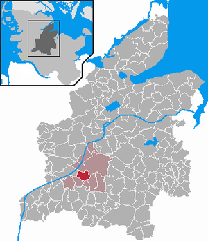
| Location of the municipality of Hamweddel in the Rendsburg-Eckernförde district | ||
Hamweddel is a municipality in the Rendsburg-Eckernförde district in Schleswig-Holstein . Legan, Heidkaten, Knebelshorst, Hennstedt, Kollmoor, Stöfsandkate, Vossberg and Wisbrook are in the municipality.
Geography and traffic
Hamweddel is located about 17 km south of Rendsburg in the Aukrug Nature Park . The community lies between the Kiel Canal and the federal highway 77 from Rendsburg to Itzehoe .
The two districts of Heidkaten and Legan belong to Hamweddel.
School buses go to Jevenstedt to the primary and secondary school "Schule an der Jevenau" and to the primary and secondary school in Todenbüttel .
history
The village was founded around 1500. The name means "forest ford".
politics
Community representation
Since the municipal elections in 2013, the KWG electoral community has all nine seats in the municipal council.
coat of arms
Blazon : “Divided by silver and red in a wavy cut to the left. Above a red wagon wheel, below three silver deciduous trees. "
economy
The municipality is predominantly agricultural, most of the farms operate dairy farming . There are four full-time businesses in Hamweddel .
Web links
Individual evidence
- ↑ North Statistics Office - Population of the municipalities in Schleswig-Holstein 4th quarter 2019 (XLSX file) (update based on the 2011 census) ( help on this ).
- ↑ Schleswig-Holstein topography. Vol. 4: Groß Sarau - Holstenniendorf . 1st edition Flying-Kiwi-Verl. Junge, Flensburg 2004, ISBN 978-3-926055-75-0 , p. 109 ( dnb.de [accessed on May 1, 2020]).
- ↑ Schleswig-Holstein's municipal coat of arms

