
Schülp b. Rendsburg
| coat of arms | Germany map | |
|---|---|---|

|
Coordinates: 54 ° 16 ' N , 9 ° 38' E |
|
| Basic data | ||
| State : | Schleswig-Holstein | |
| Circle : | Rendsburg-Eckernförde | |
| Office : | Jevenstedt | |
| Height : | 7 m above sea level NHN | |
| Area : | 10.71 km 2 | |
| Residents: | 1086 (Dec. 31, 2019) | |
| Population density : | 101 inhabitants per km 2 | |
| Postcodes : | 24813, 24768, 24797 | |
| Area code : | 04331 | |
| License plate : | RD, ECK | |
| Community key : | 01 0 58 148 | |
| Office administration address: | Meiereistraße 5 24808 Jevenstedt |
|
| Website : | ||
| Mayor : | Wolfgang Wachholz (KWG) | |
| Location of the community Schülp b. Rendsburg in the Rendsburg-Eckernförde district | ||
 |
||

Schülp b. Rendsburg (Danish: Skulleby) is a municipality in the Rendsburg-Eckernförde district in Schleswig-Holstein . Jevensberg, Rüsterbergen, Moltkestein and the pilot station are in the municipality.
Geography and traffic
The place is located on a sandy elevation directly south of Rendsburg on both sides of the Kiel Canal . There is a pilot station in the municipality of Rüsterbergen, where pilots from Kiel or Brunsbüttel change. The federal highway 77 runs to the east from Rendsburg to Itzehoe .
history
Some flint artifacts (Scharber, hatchet) from the Neolithic Age (around 4300–2300 BC) are the oldest traces in today's municipal area.
It is not known when exactly the settlement from which today's Schülp emerged was founded. In any case, it was on an Eiderfurt, which was important for north-south traffic across the Jutian peninsula ( Bernsteinweg / Ochsenweg ). The chronicler Helmold von Bosau (about before 1120 to after 1177) reports in his Slavic Chronicle that around 1149 the Holstein count Adolf II fought a battle with Danes and Dithmarschern near Schülp. The battlefield was around the northern border of the municipality, where an Eider ferry drove until the Kiel Canal was built. Coming from the north, the Heerweg met a well-passable ford there, for example from the direction of Nübbel .
The next written testimony about Schülp only comes from the 15th century: In a complaint in 1447, Count Adolf VIII mentions the attacks by the Dithmarschers on Holstein territory. The victim of the looting would be Schülp. The place is written in German for the first time and is called ´Schulpe´.
In 1580 the village was under the authority of Rendsburg, which at that time belonged to the royal Danish part of the duchies of Schleswig and Holstein. Since the 16th century, the students had to make their contribution to the construction of the Rendsburg fortress, which was expanded to become the strongest Danish fortress after Copenhagen in the 17th century.
In 1712 a plague epidemic raged, which wiped out all but two families. The plague cemetery established at that time is still in use today.
The coupling took place around 1770 and the first reliable information on the number of inhabitants is available from 1803. It was 110. The place benefited from the Schleswig-Holstein Canal ( Eider Canal ) built from 1777 to 1784 , among other things through the development of a small shipbuilding industry on the Eider.
With the Prussian rural community ordinance, the village of Schülp was transformed into a community with an elected community leader in 1867.
From 1887 to 1895 the Kiel Canal was built, which from then on divided the municipality. Until 1973, a chain ferry operated between the districts in Rüsterbergen.
Between 1901 and 1957 the Rendsburger Kreisbahn connected Schülp with Rendsburg.
Place name interpretation
Schülp was mentioned as Scullebi in the Slavic Chronicle, written by monk Helmold von Bosau at the end of the 12th century. The name probably means "hidden bend, curvature".
politics
Community representation
Of the eleven seats in the municipal council, the CDU received five seats in the 2003 local elections, while the SPD and the KWG each had three.
Of the eleven seats in the municipal council, the KWG electoral community received five, the CDU four and the SPD two seats in the 2008 local elections .
Since 2013 the seats have been divided as follows: KWG six seats, CDU three seats and SPD two seats. Mayor Otto Schneider (CDU) was replaced by Wolfgang Wachholz (KWG).
coat of arms
Blazon : “In red, a narrower silver wavy bar above a silver bar; above a golden hull on a (simple) slipway. A golden three-mountain in the base of the shield. "
In the center of the coat of arms, the narrow, moving and the wide, rigid silver ribbon represent the Eider and the Kiel Canal. As shown in the coat of arms, the two watercourses run in close proximity and almost parallel through the middle of the Schülper district.
The hull on the slipway in the upper half of the coat of arms symbolizes the heyday of the timber trade and ship carpentry trade in the second half of the 18th century. The Dreiberg im Schildfuß refers to scenic features in the municipality, such as several extensive inland dunes (Timmerbarg, Schütterberg and Moritzberg). The colors red and silver document that the municipality belongs to Holstein. The gold of the ship's hull refers to the former prosperity of the shipbuilding industry, the gold of the Dreiberg refers to the natural color of the sand.
economy
Attractions
- see also: List of cultural monuments in Schülp b. Rendsburg
- Local history museum with "Prussian registry office"
- Plague cemetery
- Moltkestein
- Nübbel pilot station
- Rüsterbergen pilot station (until November 30, 1973 dock of the canal ferry to the north bank of the Moltkestein)
- Rüsterberg

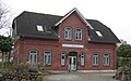
Switchman's house on the Kiel Canal
Former Schülp train station

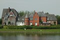
Rüsterbergen pilot station
Nübbel pilot station


Web links
Individual evidence
- ↑ North Statistics Office - Population of the municipalities in Schleswig-Holstein 4th quarter 2019 (XLSX file) (update based on the 2011 census) ( help on this ).
- ↑ Schleswig-Holstein topography. Vol. 9: Schönberg - Tielenhemme . 1st edition Flying-Kiwi-Verl. Junge, Flensburg 2007, ISBN 978-3-926055-91-0 , p. 39 ( dnb.de [accessed July 30, 2020]).
- ^ Members of the community council Schülp b. RD. Retrieved September 23, 2013 .
- ↑ Schleswig-Holstein's municipal coat of arms
- ^ Rendsburg-Eckernförde monument list. State Office for Monument Preservation Schleswig-Holstein, March 18, 2019, p. 157 , accessed on May 13, 2019 .
- ^ W. Langes: Car ferries in Germany from 1900. Nord-Ostsee-Kanal / Kiel-Kanal. Retrieved March 10, 2014 .
Backguard | Ahlefeld-Bistensee | Alt Duvenstedt | Altenhof | Altenholz | Arpsdorf | Cinderella | Aukrug | Bargstall | Bargstedt | Barkelsby | Beldorf | Bendorf | Beringstedt | Bite | Blumenthal | Böhnhusen | Bokel | Bordesholm | Borgdorf-Seedorf | Borgstedt | Bornholt | Bovenau | Brammer | Bredenbek | Pulpwood | Brekendorf | Brinjahe | Brodersby | Bruges | Büdelsdorf | Bünsdorf | Christiansholm | Damendorf | Damp | Dänischenhagen | Dätgen | Dörphof | Eckernförde | Ehndorf | Eisendorf | Ellerdorf | Elsdorf-Westermühlen | Embühren | Emkendorf | Field | Felm | Fleckeby | Flintbek | Fockbek | Friedrichsgraben | Friedrichsholm | Gammelby | Gettorf | Gnutz | Gokels | Goosefeld | Grauel | Grevenkrug | Groß Buchwald | Groß Vollstedt | Groß Wittensee | Güby | Haale | Haby | Hamdorf | Hamweddel | Hanerau-Hademarschen | Hassmoor | Heinkenborstel | Hofeld | Hohenwestedt | Scorn | Holtsee | Holzbunge | Holzdorf | Hearst | Hummelfeld | Huts | Year village | Jevenstedt | Karby | Klein Wittensee | King's Hill | Kosel | Crogaspe | Kronshagen | Curvilinear | Long tail | Lindau | Lohe-Föhrden | Loop | Loose | Luhnstedt | Lütjenwestedt | Meezen | Melsdorf | Mielkendorf | Molfsee | Mörel | Mühbrook | Negenharry | Neudorf-Bornstein | New Duvenstedt | Neuwittenbek | Nienborstel | Nindorf | Noer | Nortorf | Nübbel | Oldenbüttel | Oldenhütten | Osdorf | Ostenfeld (Rendsburg) | Osterby | Osterrönfeld | Osterstedt | Ottendorf | Owschlag | Padenstedt | Prince's Moor | Quarnbek | Rade b. Hohenwestedt | Rade b. Rendsburg | Reesdorf | Remmels | Rendsburg | Rickert | Rieseby | Rodenbek | Rumohr | Schacht-Audorf | Schierensee | Schinkel | Schmalstede | Schönbek | Schönhorst | Schülldorf | Schülp b. Nortorf | Schülp b. Rendsburg | Schwedeneck | Seefeld | Sehestedt | Sophienhamm | Sören | Stafstedt | Steenfeld | Beaches | Tackesdorf | Tappendorf | Techelsdorf | Thaden | Thumby | Timmaspe | Todenbüttel | Tüttendorf | Waabs | Wapelfeld | Warder | Wasbek | Wattenbek | Westensee | Westerrönfeld | Windeby | Winnemark