Haale
| coat of arms | Germany map | |
|---|---|---|

|
Coordinates: 54 ° 10 ' N , 9 ° 33' E |
|
| Basic data | ||
| State : | Schleswig-Holstein | |
| Circle : | Rendsburg-Eckernförde | |
| Office : | Jevenstedt | |
| Height : | 8 m above sea level NHN | |
| Area : | 13.03 km 2 | |
| Residents: | 511 (Dec. 31, 2019) | |
| Population density : | 39 inhabitants per km 2 | |
| Postal code : | 24819 | |
| Area code : | 04874 | |
| License plate : | RD, ECK | |
| Community key : | 01 0 58 068 | |
| Office administration address: | Meiereistraße 5 24808 Jevenstedt |
|
| Website : | ||
| Mayor : | Bernd Holm (KWG) | |
| Location of the municipality of Haale in the Rendsburg-Eckernförde district | ||
Haale is a municipality in the Rendsburg-Eckernförde district in Schleswig-Holstein . Nienrade, Marsch, Lust, Knüll, Steinberg, Saaland, Oland, Wettersberg and Koppelzeile are in the municipality.
Geography and traffic
Haale is 16 km southwest of Rendsburg on the south bank of the Kiel Canal . The federal highway 77 runs to the east from Rendsburg to Itzehoe . The Haaler Au runs to the west of the municipality .
politics
Community representation
All nine seats in the municipal council have been held by the KWG electoral community since the 2013 local elections.
coat of arms
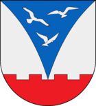
Blazon : "Above a red flat pewter shield foot in silver a curved, overturned blue tip, in it three silver birds in flight."
economy
The municipality is predominantly agricultural.
Personalities
- The local poet Timm Kröger (1844-1918) and his nephew, the imperial building officer and church builder Jürgen Kröger (1856-1928), were born in Haale.
- The painter, draftsman, sculptor and architect Ingo Kühl (* 1953) worked as a freelancer from 1976–1982 in the Dr. Jüchser & Ressel in Haale.
Web links
Commons : Haale - collection of images, videos and audio files
Individual evidence
- ↑ North Statistics Office - Population of the municipalities in Schleswig-Holstein 4th quarter 2019 (XLSX file) (update based on the 2011 census) ( help on this ).
- ↑ Schleswig-Holstein topography. Vol. 4: Groß Sarau - Holstenniendorf . 1st edition Flying-Kiwi-Verl. Junge, Flensburg 2004, ISBN 978-3-926055-75-0 , p. 72 ( dnb.de [accessed on May 1, 2020]).
- ↑ Schleswig-Holstein's municipal coat of arms

