Todenbüttel
| coat of arms | Germany map | |
|---|---|---|

|
Coordinates: 54 ° 8 ' N , 9 ° 33' E |
|
| Basic data | ||
| State : | Schleswig-Holstein | |
| Circle : | Rendsburg-Eckernförde | |
| Office : | Mittelholstein | |
| Height : | 18 m above sea level NHN | |
| Area : | 11.78 km 2 | |
| Residents: | 1020 (Dec. 31, 2019) | |
| Population density : | 87 inhabitants per km 2 | |
| Postal code : | 24819 | |
| Area code : | 04874 | |
| License plate : | RD, ECK | |
| Community key : | 01 0 58 164 | |
| LOCODE : | DE 69A | |
| Office administration address: | Am Markt 15 24594 Hohenwestedt |
|
| Website : | ||
| Mayor : | Otto Harders (AWG) | |
| Location of the municipality of Todenbüttel in the Rendsburg-Eckernförde district | ||
Todenbüttel is a municipality in the Rendsburg-Eckernförde district in Schleswig-Holstein . Maisborstel is located in the municipality.
Geography and traffic
Todenbüttel is located 20 km southwest of Rendsburg and 26 km east of Heide in a rural area. The federal highway 77 runs to the east from Rendsburg to Itzehoe and to the southwest the federal highway 23 runs from Heide to Hamburg . The Kiel Canal runs north .
history
In terms of settlement history, Todenbüttel is one of the Büttel localities. The Evangelical Lutheran Trinity Church in Todenbüttel inaugurated on October 5, 1863 after two years of construction, Bishop Wilhelm Heinrich Koopmann . The parish includes Beringstedt , Haale , Lütjenwestedt , Osterstedt and Todenbüttel. Before the church was built, Todenbüttel belonged to the parish of Schenefeld .
politics
Community representation
Of the eleven seats in the municipal council, the AWG electoral community has had all seats since the 2013 local elections.
coat of arms
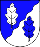
Blazon : "Of blue and silver obliquely left in a wavy cut divided with two oak leaves in confused colors."
Economy and Infrastructure
The community was originally characterized by agriculture, but today residential use predominates. There is also a comprehensive service structure.
education
The villages of Embühren , Haale , Beringstedt , Seefeld , Osterstedt , Nienborstel and Todenbüttel belong to the Todenbüttel village community school . The school building consists of three largely interconnected tracts and the old school building from 1951. Some of them have been adapted for disabled people. With another extension, completed in summer 2002, the school has around 40 rooms and 660 students. The school has a school forest, which has been continuously expanded since 1972, e.g. B. with ponds and an apiary. In 2005 a film room with chairs and television sets was set up in the basement of the 1951 building.
Attractions
sons and daughters of the town
- Johannes Herbert Schroeder (1939–2018), German geoscientist
Web links
Individual evidence
- ↑ North Statistics Office - Population of the municipalities in Schleswig-Holstein 4th quarter 2019 (XLSX file) (update based on the 2011 census) ( help on this ).
- ↑ Schleswig-Holstein topography. Vol. 10: Timmaspe - Ziethen . 1st edition Flying-Kiwi-Verl. Junge, Flensburg 2008, ISBN 978-3-926055-92-7 , p. 11 ( dnb.de [accessed on August 6, 2020]).
- ^ "Dreieinigkeitskirche Todenbüttel" ( Memento from March 20, 2013 in the Internet Archive )
- ↑ , Internet pages of the Evangelical Lutheran Church Community of Todenbüttel: Church for Todenbüttel, Beringstedt, Osterstedt, Haale and Lütjenwestedt ( memento of November 7, 2016 in the Internet Archive ), accessed on November 18, 2012.
- ↑ Allocation of seats after the 2013 municipal elections ( memento of the original from December 20, 2013 in the Internet Archive ) Info: The archive link was automatically inserted and not yet checked. Please check the original and archive link according to the instructions and then remove this notice.
- ↑ Schleswig-Holstein's municipal coat of arms


