Osterby (Rendsburg-Eckernförde district)
| coat of arms | Germany map | |
|---|---|---|

|
Coordinates: 54 ° 27 ' N , 9 ° 45' E |
|
| Basic data | ||
| State : | Schleswig-Holstein | |
| Circle : | Rendsburg-Eckernförde | |
| Office : | Hüttener Mountains | |
| Height : | 18 m above sea level NHN | |
| Area : | 9.84 km 2 | |
| Residents: | 1001 (Dec. 31, 2019) | |
| Population density : | 102 inhabitants per km 2 | |
| Postal code : | 24367 | |
| Area code : | 04351 | |
| License plate : | RD, ECK | |
| Community key : | 01 0 58 123 | |
| Office administration address: | Mühlenstrasse 8 24361 Groß Wittensee |
|
| Website : | ||
| Mayor : | Heino Bothmann ( CDU ) | |
| Location of the municipality of Osterby in the Rendsburg-Eckernförde district | ||
Osterby ( Danish Østerby ) is a municipality in the district of Rendsburg-Eckernförde in Schleswig-Holstein .
Geography and traffic
Osterby is about 6 km west of Eckernförde in the Hüttener Mountains . The federal highway 203 runs south-east from Rendsburg to Eckernförde and north the federal highway 76 from Eckernförde to Schleswig .
history
Osterby was first mentioned on October 7, 1528 under the name Osterbuj. The place was a Jutish settlement ( Danish : by for village, settlement ) on the eastern edge of a large forest between the Eider and Schlei . In the Middle Ages, the forests and moors between the Eider and the Schlei formed a natural border between the Danes and Saxons. Around 1550 the Jutes mixed with the Saxons advancing from the south . The inhabitants of Osterby wrestled their lands from the forest and the moor very early on by reclamation. Old hall names such as Holzkoppel, Haselhorst, Moorwiese and Wolfsbrook say this.
During the 1st German-Danish War in 1848 the village was fought over. This is reminiscent of a memorial stone with the inscription " Up forever ungedeelt ", which was inaugurated in 1898 for the 50th anniversary. Until 1950 Osterby was a purely farming village with handicraft businesses and merchants important for the residents. In the past 25 years, the place has grown through a few new development areas and serves primarily as a popular residential area for commuters to the nearby Eckernförde .
politics
Community representation
Of the eleven seats in the municipal council has CDU since the local elections in 2013 five seats, the SPD and the voter community KWG have three each. This election result was confirmed in the 2018 local elections.
coat of arms
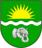
Blazon : "In green a silver wavy bar, accompanied above by a shining golden sun above, below by a silver hair knot (Suebian knot)."
The wavy bar in the coat of arms represents the Osterbek brook and the Sueben knot refers to the skull of a bog body found near the place (see man from Osterby ).
economy
The community has several full-time agricultural businesses and several craft businesses.
Web links
Individual evidence
- ↑ North Statistics Office - Population of the municipalities in Schleswig-Holstein 4th quarter 2019 (XLSX file) (update based on the 2011 census) ( help on this ).
- ↑ a b community council. Osterby Congregation: accessed October 18, 2018 .
- ↑ Schleswig-Holstein's municipal coat of arms


