Wapelfeld
| coat of arms | Germany map | |
|---|---|---|

|
Coordinates: 54 ° 5 ' N , 9 ° 36' E |
|
| Basic data | ||
| State : | Schleswig-Holstein | |
| Circle : | Rendsburg-Eckernförde | |
| Office : | Mittelholstein | |
| Height : | 14 m above sea level NHN | |
| Area : | 8.11 km 2 | |
| Residents: | 324 (Dec. 31, 2019) | |
| Population density : | 40 inhabitants per km 2 | |
| Postal code : | 24594 | |
| Area code : | 04871 | |
| License plate : | RD, ECK | |
| Community key : | 01 0 58 167 | |
| Address of the municipal administration: |
Am Markt 15 24594 Hohenwestedt |
|
| Website : | ||
| Mayor : | Volker Delfs (KWG) | |
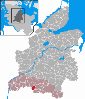
| Location of the municipality of Wapelfeld in the Rendsburg-Eckernförde district | ||
Wapelfeld is a municipality in the Rendsburg-Eckernförde district in Schleswig-Holstein .
Geography and traffic
The municipality of Wapelfeld is located on the Haaler Au , a small river which, together with the Papenau, drains the higher areas in the nearby Aukrug Nature Park . The federal highway 430 from Neumünster to the federal highway 23 leads past Wapelfeld. There is a rail connection in nearby Hohenwestedt (Neumünster - Heide route ). From 1901 to 1957 Wapelfeld was the railway station of the Rendsburger Kreisbahn .
history
In 1248 the place is mentioned for the first time in a script as a woodless land by standing water .
politics
Community representation
The KWG electoral community has had all nine seats in the municipal council since the 2013 local elections.
coat of arms
Blazon : "In gold a raised oblique left openwork blue wave bar, top right a red wheel, bottom left above a green picket fence growing in the base of a shield, a green rush."
Personalities
The agricultural chemist Richard Thun (1899–1945) was born in Wapelfeld.
Web links
Individual evidence
- ↑ North Statistics Office - Population of the municipalities in Schleswig-Holstein 4th quarter 2019 (XLSX file) (update based on the 2011 census) ( help on this ).
- ↑ Allocation of seats after the 2013 local elections ( Memento of the original from May 20, 2015 in the Internet Archive ) Info: The archive link was automatically inserted and not yet checked. Please check the original and archive link according to the instructions and then remove this notice.
- ↑ Schleswig-Holstein's municipal coat of arms

