
Eckernförde Bay

The Eckernförde Bay or Eckernförde Meerbusen ( Danish : Egernførde Fjord, Egernførde Bugt or Egernfjord ) is a fjord on the Baltic Sea and a branch of the Kiel Bay in Schleswig-Holstein . It lies between the Danish Wohld in the south and Schwansen in the north.
The Eckernförde Bay extends 17 kilometers deep into the country and is ten kilometers wide at its entrance, with Booknis-Eck (municipality of Waabs ) and Dänisch-Nienhof (municipality of Schwedeneck ) as the endpoints . The bay is up to about 28.50 meters deep. In terms of international law , the Eckernförde Bay is a “real bay”.
Surname
The name is derived from Eckernförde , where Eckern - probably for squirrels (Danish egern ) and -förde for a ford . The name of the bay was recorded in writing in 1416 as Ekelvordsche Vorde . The bay was accordingly also referred to as the fjord or Wik. The major Danish designations Egernførde inlet and Egern inlet rewrite the bay respectively as conveying ( North. Fjord ). In part, a distinction is also made between the inner Egernførde Fjord and the outer Egernførde Bugt .
Geology and natural space

The bay was created during the last ice age ( Vistula Ice Age ) 120,000 to 10,000 years ago by a glacier tongue . According to some geologists, the depth line of the Eckernförde Bay is said to have been created before the Ice Age and, according to this assumption, contributed to the fact that the "Eckernförde Lobus " in the area of today's Eckernförde divided into two parts of the ice age : the northern " Windebyer-Noor tongue "And the southern" Wittensee - Goossee tongue ".
The original postglacial end of Eckernförde Bay, today's Windebyer Noor, is now separated from the Baltic Sea by a spit on which the town of Eckernförde was formed. The final separation took place artificially in 1929 through embankments - there are now plans to re-establish an open connection between Eckernförde Bay and Windebyer Noor.
The shores of the bay are shaped by the water and the surf . Particularly with wind from the northeast and southwest, a considerable swell can build up. When the water level is 0.75 meters higher, sand and gravel are removed from the cliff coast . In some places, the coastline recedes by 15 to 20 centimeters every year. In the southeast the hills of the terminal moraines of the last Ice Age are cut. In this way, a 30 meter high and 3.6 kilometer long cliff has formed in front of Altenhof . Its steadily eroded material is partly deposited further west and separated the Goossee from the Eckernförde Bay. Several sand reefs run parallel to the beach . The banks are mainly forested with deciduous trees.

Steep coast near Schnellmark

Beech forest on the Eckernförde Bay in Noer

Steep bank at Jellenbek in the Danish Wohld

in a sailing yacht on Eckernförde Bay

Beach in Eckernförde with the Kranzfelder Hafen in the background

North Rhine-Westphalia (F 223) near Surendorf
Åland ring quartz porphyry, found in: Eckernförde Bay

Oslo basalt, found in: Eckernförde Bay

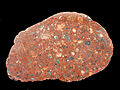
Faxe lime, found in: Eckernförde Bay

Skolithos sandstone, place of discovery: Klein-Waabs

Brick lime with endoceras, place of discovery: Klein-Waabs


Cities and municipalities on the edge of the book
The bank of the Eckernförde Bay borders completely on the Rendsburg-Eckernförde district (old Eckernförde district). The communities Waabs (at the bay entrance) and Barkelsby are on the north bank, and the communities Schwedeneck (also bay entrance), Noer and Altenhof are on the south bank from east to west . The eponymous town of Eckernförde is located on the western tip of the bay, the districts of Borby and Louisenberg on the western end of the north bank.
history
After the settlement of Schwansen with Danish settlers from around 700 and that of the Danish Wohldes with (north) German settlers from 1260, the Eckernförde Bay formed a linguistic border between Low German in the south and Danish / Angel Danish in the north in the Middle Ages. This can still be seen today from the Nordic place names in Schwansen. Later, German as a colloquial language spread further north. The Angel Danish was used in Schwansen until the 19th century. In the early modern period, both swans and Danish welfare were characterized by lordship and serfdom .
During the battle at Eckernförde in 1849, the Danish ship of the line Christian VIII and the Danish frigate Gefion were shot at by beach batteries from Schleswig-Holstein troops, with the ship of the line exploding , the frigate surrendering and being taken over by the German-oriented Schleswig-Holstein army .
A few years later, the storm floods in the Baltic Sea in 1872 caused severe damage to the coastal towns of Eckernförde Bay. The city of Eckernförde in particular suffered severe damage.
Economy, infrastructure and transport

The Eckernförde Bay is a popular holiday destination. The Ostseebad Eckernförde records around 135,000 overnight stays a year, and there are eleven campsites around the bay. The sailing area is also the starting point for the eel regatta for the Kiel Week .
The Bundeswehr has several properties in operation around Eckernförde Bay. At the south-eastern end of the bay, on the opposite north-eastern bank (still in Eckernförde) and at the south-western exit of the bay in Surendorf, there are departments of the Defense Technology Service for Ships and Naval Weapons, Maritime Technology and Research (WTD 71) . There is a pier in Surendorf, which is part of the military restricted area and therefore cannot be entered.
Today the B 76 runs from Eckernförde to Kiel between Goossee and Eckernförde Bay . Already around 1500 there was evidence of a road on the beach wall, which was later converted into a dam. The dam was badly damaged in the flood of the Baltic Sea in 1872, so that the road that had been built in the meantime was no longer passable. When the road was rebuilt, the dam was raised. The street received its current shape in 1965.
The Kiel – Flensburg railway (built by the Kiel-Eckernförde-Flensburger Eisenbahn-Gesellschaft ), which is now operated by the Schleswig-Holstein regional railway , runs parallel to this .
The Eckernförde Bay is well developed with cycle paths, including the Baltic Sea Cycle Path , which leads around the Baltic Sea within the European EuroVelo network and thus the region. a. connects with Kiel, Lübeck and Copenhagen.
Ports and landing stages

Under the definition of the Booknis-Eck-Dänisch-Nienhof-Linie as the eastern end of the Eckernförde Gulf, there are only port facilities in Eckernförde and Altenhof: The Eckernförde city port serves, among other things, as a fishing port and traditional sailing port. There is a small shipyard there. In addition, Eckernförde has a marine port (" Kranzfelder Hafen ", named after Alfred Kranzfelder ), two yacht harbors and a landing stage at the torpedo launching track (military restricted area in Eckernförde Bay). In addition, there is the already mentioned pier in Surendorf and a "natural harbor" (dredged headland) suitable for mooring yachts and smaller military ships in the Aschauer Lagune (or: Kronsort ) within the municipality of Altenhof.
The grass snake - a buoy - limits the overall range of Eckernförder ports including in the Eckernförde Bay harbor from -Seeflächen. It serves as an orientation for ships that call at Eckernförde. In the 1990s, it was enough to go around the grass snake on a passenger ship or fishing cutter for duty-free shopping.
Individual evidence
- ^ Carl Ferdinand Allen: Det danske sprogs historie i hertugdømmet Slesvig eller Sønderjylland , Volume 1, Kjøbenhavn 1857, page 3
- ^ Erwin Beckert, Gerhard Breuer: Public Maritime Law. de Gruyter, Berlin / New York 1991, ISBN 3-11-009655-2 , p. 54.
- ↑ Wolfgang Laur: Historisches Ortsnamelexikon von Schleswig-Holstein , 2nd edition, Neumünster 1992, p. 226
- ↑ so with Hector Boeck: Kort over Sydslesvig , 1950/53
- ↑ Cycling - LTO Eckernförde Bay. Retrieved May 7, 2017 .
- ↑ Baltic Sea Cycle Route - Baltic Sea Schleswig Holstein. Retrieved May 7, 2017 .
- ↑ translator2: EuroVelo 10 - EuroVelo. Retrieved May 7, 2017 .
Web links
Coordinates: 54 ° 29 ′ 55 ″ N , 10 ° 0 ′ 54 ″ E