Einfelder See
| Einfelder See | ||
|---|---|---|
|
|
||
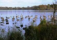
| Einfelder See to the north, from the Einfelder village bay | ||
| Geographical location | In the middle of Schleswig-Holstein | |
| Tributaries | Dig out the canned moor | |
| Drain | Aalbek | |
| Places on the shore | Einfeld , Mühbrook | |
| Data | ||
| Coordinates | 54 ° 8 ′ 29 " N , 10 ° 0 ′ 4" E | |
|
|
||
| Altitude above sea level | 26.79 m above sea level NN | |
| surface | 1.68 km² | |
| length | 3 km | |
| width | 700 m | |
| volume | 6,260,000 m³ | |
| scope | 9.2 km | |
| Maximum depth | 8.2 m | |
| Middle deep | 3.73 m | |
| PH value | 8.9 | |
| Catchment area | 9.2 km² | |
|
particularities |
Nature reserve on the western bank |
|
The Einfelder See is a lake in Schleswig-Holstein , in close proximity to the city of Neumünster . It is in the area of the Rendsburg-Eckernförde district and the independent city of Neumünster. With an area of 168 hectares, it is one of the larger lakes in Schleswig-Holstein.
General
The lake lies on the watershed of two rivers, the Eider in the north and the Stör in the south . A small inflow comes from the Dosenmoor into the lake, other noteworthy tributaries are missing. For this reason, the lake is mainly fed by groundwater and precipitation. A main drain goes to the Aalbek in the southeast ; in the north, the stone ditch, regulated by a weir, connects the Einfelder See with the Bordesholmer See , whose water can flow into the Eider.

On the western bank is the nature reserve west bank of the Einfelder See . About 2.4 hectares were placed under protection as early as 1955, and in 1987 it was expanded to its current size of about 13 hectares. It includes three different vegetation zones: the tree and bush zone, the bank and reed area and a floating leaf community made up of aquatic plants. The area offers protection and retreat for many waterfowl.
history
Together with the Bordesholmer See, the Einfelder See forms the remains of the drainage valley, which was created as a subglacial tunnel valley during the Vistula Ice Age . To the east and west of the lake there are moraines , the eastern one is responsible for bogging the landscape and the formation of the canned bog. Towards the north, the draining water formed a sand landscape .
On the western shore of the lake are the remains of the Margarethenschanze , a hill fort from the 9th century.
For the construction of the Eider Canal , a possible route from Kiel to the Lower Elbe , which led through the Einfelder See, was examined in 1774 . The glacial channel from Obereider, Bothkamper , Bordesholmer and Einfelder See should be used for this. After the watershed at Einfelder See, the Lower Elbe would have been reached via the two rivers Schwale and Stör.
Flora and fauna

The shores of the lake are comparatively flat. On the banks there are flat silting zones in many areas. These areas have a vegetation with immersion and floating leaf plants as well as reed and broken forest stands . The average width of the overgrown bank zone is around 10 m, but sometimes around 50 m are reached.
Recreation and culture
water sports
Beach sections with sunbathing lawns are located on the east side of the lake and at the Einfeld village bay. Some clubs have boathouses on the southeast side of the lake. Driving on the lake with rowing and sailing boats as well as with canoes and kayaks is permitted.
"Stones at the lake"
The works of art created at the Neumünster International Sculpture Symposium in 1989 are displayed on the north-eastern beach. An information board explains that the stone sculptures should "emphasize the harmony of art and nature."
Jan Koblasa : "David and Goliath"; Diabase
Wolf Gloßner: "Signs of Life"; Diorite
Jesper Neergaard : “Morning and Evening”; red granite
literature
- Joachim Thode: Stones at Lake Einfelder See: International Sculpture Symposium Neumünster with an introduction by Martin Sadeck. Wachholtz, Neumünster 1990, ISBN 3-529-02698-0 .
See also
- List of lakes in Schleswig-Holstein
- List of lakes in Germany
- A field
- Sculpture Symposium St. Margarethen
- Sculpture symposium Kaisersteinbruch
Web links
- NSG west bank of the Einfelder See
- Different angle of view of the stones
- Einfeld viewing points (including the history of Einfelder See) (PDF, 1.6 MB)
Individual evidence
- ↑ a b c d e f Einfelder See: Characteristic data. In: Ministry for Energy Transition, Agriculture, Environment and Rural Areas Schleswig-Holstein: Lakes (accessed on September 16, 2012)
- ↑ a b Brigitte Nixdorf, Mike Hemm, Anja Hoffmann, Peggy Richter: Documentation of the condition and development of the most important lakes in Germany. Part 1: Schleswig-Holstein . Final report R&D project FKZ 299 24 274 on behalf of the Federal Environment Agency, 2004 ( PDF file; 2.1 MB )
- ^ Manfred Jessen-Klingenberg : The Schleswig-Holstein Canal - Eider Canal. Prehistory, origin, meaning. In: Communications from the Kiel Society for City History. Volume 85, Issue 3, 2010, p. 118.


