
Scharhorn
| Scharhorn | ||
|---|---|---|
 |
||
| Waters | Helgoland Bay | |
| Archipelago | Scharhorn | |
| Geographical location | 53 ° 57 '42 " N , 8 ° 26' 29" E | |
|
||
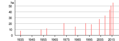
| surface | 43.16 ha | |
| Highest elevation | 6 m | |
| Residents | 1 Vogelwart 2.3 inhabitants / km² |
|


Scharhörn is a German island in the innermost corner of the Heligoland Bay and part of an exclave of the Free and Hanseatic City of Hamburg ( Neuwerk district ). The island is considered Hamburg's northernmost point and is around 43 hectares in size. Scharhörn, the surrounding mudflats and the lake area are in "Zone I" of the Hamburg Wadden Sea National Park and are a geotope of supraregional importance. Apart from a bird watchdog, the island is uninhabited and can only be reached via a mudflat hiking trail from Neuwerk .
geography
location
In the innermost corner of the Helgoland Bay, Scharhörn lies at river kilometer 745, on the left of the Elbe , which flows into the North Sea here . It is located in the north of the Scharhörn-Neuwerker Watt , which is bordered by the Elbe in the northwest and Till in the south and makes up the northernmost area of the Elbe-Weser Watt . Scharhörn lies on the Scharhörnplate sandbank (also known as Scharhörnsand ) together with the island of Nigehörn, which is also basically flood-proof .
Natural allocation
Scharhörn and the surrounding Neuwerker Watt belong to the main natural unit group Ems- and Wesermarschen (No. 61) of the natural area Watten in the Elbe-Weser triangle Jadebusen . At the upper level, it belongs as part of the marshland to the greater region of North German Lowlands .
Surroundings
The island of Neuwerk is about 6 km southeast , and the former Hamburg state area of Cuxhaven is 15 km southeast . On the other side of the Elbe, the island of Trischen is 19 km to the northeast. Helgoland is 43 km away in the north-west.
description
The island is characterized by up to 6 m above sea level. NN high dune ridges, which mostly extend north-south and alternate with valleys, some of which are only just above NN.
The lake-side shore is characterized by a beach and dune edges. In the south-west there is an extensive salt marsh , which in the south almost comes close to Nigehorns and whose waterfall area in the west extends far beyond an imaginary straight connecting line between the two beaches. This salt marsh is intersected by a tidal creek on this straight connecting straight and by a small tidal creek system that connects directly to the beach on the southwest side and flows off towards the northwest. On the southeast side, the island flows smoothly and without creeks into a salt marsh and samphire corridor before it runs out into the mudflats without clear borders. In the south, a young tidal creek runs through this salt meadow towards Hundebalje , which extends to the neighboring island of Nigehörn.
_2.jpg)
Despite considerable attempts at the time to fortify the island with sand rinsing and sand trap fences until the 1980s, there is a constant threat of land loss in the north-west during a storm surge , while it continues to grow in the south-east due to sand deposits in the pioneer vegetation . However, the rate of removal has decreased from 20.4 m / year (1930–1948) to 7.9 m / year (1997–2004). In the long term, the midpoint has shifted 9.7 meters per year between 1935 and 2016. Since the mid-1990s, migration of the southeastern edge of the island has predominated, which has led to a considerable expansion of the island. Even if precise measurements are missing, it can be clearly observed that the entire watt range, especially between Scharhörn and Ni-horn, has increased by about one meter. The resulting salt marshes already connect the islands and further amalgamation of the islands is to be expected. In the period from 2000 to 2013, the center of the island moved 173 m and the eastern edge by 265 m. Additional vegetation islands have formed west of the island.
Since the Nighörn was washed up on the Scharhörnplate approx. 1.5 km further south-west in 1989, this island has also enlarged further to the east. In 2014, the land reclamation of Nighorn reached almost beyond Scharhörn in an easterly direction.
Area development
In the spring of 2018 there was an unusually heavy dune formation on the eastern edge of Scharhörn, which at least in the short term changed the location, size and also the relationship between salt marshes and dunes significantly.
Surname
Today the name Scharhörn refers to the dune island, which lies on the Scharhörnplate together with Nigehörn . In some cases, Scharhörn is still used on maps as a synonym for the Scharhörnplate and thus also includes Nighörn. In different spellings, Scharhörn was for centuries the name of various extensive sandbanks on the south side of the Outer Elbe, which were shifted by the current.

Willem Blaeu calls it Schorhörn in his map of the Lower Elbe from 1628 . Other spellings are Scharhoern , Schoor-Hörn and Scharhörn . In Middle Low German, schore or schare stands for foreland, shore, coast or wall. As an adjective , it stands for weird. Hörn stands for corner, edge, angle or headland. Put together, the steep edge indicates the location and shape of the sandbar.
history


After Scharhörn was mentioned as a sandbank and a great danger for shipping between Weser and Elbe as early as the 13th century , it was mainly navigation signs such as the Schartonne (1446) and the Scharhörnbake (1661) that indirectly referred to Scharhörn. The Neuwerker Tower was an expression of Hamburg's rule over the Elbe estuary, but, together with the Neuwerker Blüsen and lighthouses, not least served to secure the passage on the Outer Elbe around the dreaded sandbank. Nevertheless, the steeply sloping sands around Scharhörn were the end of various ships well into the 20th century, as the wreck of the Ondo on the opposite bird sand still testifies to today.
The Scharhörnbake, which was first built in 1661, was replaced several times and in 1852 a flood-proof shelter with emergency equipment for seafarers who had had an accident was added. It was demolished for the Franco-Prussian War (1870) and First World War (1914) so as not to provide navigation aid for enemy fleets, and rebuilt after the wars. Its importance is also proven by the fact that it was at times the highest beacon on the North Sea coast. On August 7, 1967, the remains of the last Scharhörn beacon were removed.
Accurate cartographic records from 1868 onwards show that the sandbank had shifted about 1.4 km to the southeast by 1968.
The Neuwerker teacher Heinrich Gechter discovered nesting sandwich terns in 1902 and the first vegetation in 1926. Through press and lobbying work, he managed to get Hamburg to finance “the increase and planting of the Scharhörn sand to support nature”. From 1927 systematic and extensive work with sand trap fences and later also planting, sowing and harvesting beach rye and other dune grasses took place. For this purpose, building sheds were built from 1929 to accommodate the labor service of the Cuxhaven hydraulic engineering office. By the end of the 1930s, an island was created that has been documented with a size between 4 and 12 hectares.
With the Greater Hamburg Act , Scharhörn went to Prussia in 1937 in the Ritzebüttel office together with Cuxhaven and Neuwerk .
Gechter also managed to have the area declared a nature reserve on December 1, 1939. The Jordsand association , of which he was meanwhile second chairman, took over the supervision together with the Helgoland ornithological station .
The expansion of the island and nature conservation were interrupted by the Second World War. Bunkers and flak positions were built.
After the end of the war, up to 60 workers were stationed on the island and row drills were used for sowing.
From 1964 to 1979, Scharhörn was shaped by explorations and plans for a deep-water port. Since some planning variants included the port facilities at this location, the first ideas for a replacement island emerged. When the island's substance deteriorated from 1973 onwards, this idea was taken up in 1989 in order to create a long-term replacement for Scharhörn with Ni-horns. After the dune protection on Scharhörn was discontinued in 1975, these flushing and pre-flushing operations were the last and largest interventions in this area.
With the proclamation of the national park in 1990, Scharhörn became the core area of the highest protection status of "Zone 1".
At the end of the 1990s, a large area of blue-green algae formed on the increasingly less flooded mudflat between Scharhörn and Nigehörn, which could be the basis of the spring meadow that has appeared since 2002 and which now occupies almost the entire Scharhörnplate.
economy
Deep water port

Like the neighboring island of Neuwerk , Scharhörn was transferred to the Prussian province of Hanover in 1937 by the Greater Hamburg Act . From 1947 it belonged to the newly formed state of Lower Saxony until it was transferred again to the state of Hamburg in 1969 through the Cuxhaven Treaty , as the Hanseatic city intended to build a deep-water port Scharhörn / Neuwerk on the two islands. The plans envisaged an area with 6000 hectares of usable area, which should reach heights safe from storm surges through the backfilling of dredged sand in the planning area. The focus here was on the establishment of steelworks and the chemical industry on new, affordable areas. The connection to the mainland was to be made via a dam between Scharhörn, Neuwerk and Cuxhaven and, in addition to the goods, would transport the likely 4,000-5,000 workers. The project was planned in various stages of expansion with a steel and nuclear power plant until 1979, but not implemented due to numerous protests, high costs and little support from industry, but is still included in the Hamburg zoning plan :
“The zoning plan represents areas for an industrial port in the area of the Elbe estuary near Neuwerk / Scharhörn (around 3,000 ha). From today's perspective, it is not foreseeable that these areas will be used for port purposes. However, due to the long-term development in the port industry that cannot be assessed, the option of creating a deep-water port at Neuwerk / Scharhörn cannot be given up.
The zoning plan for the Neuwerk / Scharhörn area represents the Hamburg Wadden Sea National Park as an informational takeover. A clarification of the planning conflict caused by this and other nature conservation regulations, including EU law, should be undertaken if the port project is deemed to be necessary. "
rubbish
.jpg)
.jpg)
The exposed location on the busy Outer Elbe leads to very high levels of waste in Scharhörn. In 1980, 11,500 pieces of garbage with a total weight of 6 tons were found on a stretch of 100 meters on the north-west beach within 14 days. The garbage is mainly made up of pieces of wood, cordage, bottles and plastic, whereby millimeter-sized pellets, oil and paraffins pose a particular danger to the animal world.
On the Elbe-side beach there is a 100 m long stretch on which washed up rubbish has been counted, weighed and classified by the Jordsand Association since 1980 . This stretch is part of the monitoring work to control the OSPAR agreement for the protection of the north-eastern Atlantic region.
Accidents

Since the shipping route between the North Sea and the Baltic Sea shifted from the Eider to the Elbe in the 13th century, the Scharhörnriff and the sands opposite have been marked by ship accidents. Occasionally the Scharhörner "ship cemetery" is called the largest of all.
In addition to the previously common practice of cleaning tanks at sea, storms and ship accidents also lead to oil pollution of the Elbe estuary. For example, Gerd Mærsk, laden with crude oil, leaked a leak on the Scharhörn Reef during a heavy snowstorm with hurricane strength on January 16, 1955 on a trip to Hamburg. During the rescue operation, it was decided to pump part of the cargo overboard in order to save the ship from breaking apart, releasing around 7,000–8,000 tons of crude oil. The oil spill now covered an area of 1,600 square kilometers and, despite considerable attempts to control it, reached the islands of Amrum , Föhr , Sylt , Rømø and Fanø . As far as Esbjerg , the pollution caused extensive bird deaths.
The Greek freighter Emmanuel M (5400 GRT) ran aground off Scharhörn on December 8, 1968 and is looted by the Neuwerkers . She was recovered in July 1970 and towed to Cuxhaven.
The Russian freighter Njandoma broke up on Scharhörn in 1969 with toxic chemicals on board. The barrels could be recovered from the ship halves.
On October 28, 1974, the turnaround of the Cypriot freighter "Great Luck" (4300 GRT) failed after the auxiliary diesel failed in a storm. The ship was stuck at Scharhörn until it was salvaged on November 17.
level
In the area of the Outer Elbe in front of Scharhörn there are several gauges for measuring wind, current and water level.
| Surname | Position in the Elbe river | Coordinates |
|---|---|---|
| Ten hole | 732.20 km, right | 53 ° 57 '19.88 " N , 8 ° 39' 29.33" O |
| Middle ground | 733.70 km, left | 53 ° 56 '31.52 " N , 8 ° 38' 10.01" E |
| Beacon C, Scharhörn | 745.00 km, left | 53 ° 58 '1.39 " N , 8 ° 27" 44.91 " E |
| Beacon A | 755.60 km, left | 53 ° 59 ′ 3.96 " N , 8 ° 18 ′ 54.2" E |
| Beacon Z | 756.20 km, right | 54 ° 0 ′ 48.71 " N , 8 ° 18 ′ 52.26" E |
None of these levels dry out at low tide. They are not to be confused with the earlier beacons that were located on the higher-lying sands , and they also have no rescue function. In contrast to the mudflat route between Neuwerk and the mainland, there are no rescue beacons between Scharhörn and Neuwerk.
Tide forecast
The tides on Scharhörn come about 45–60 minutes earlier than on Steubenhöft (Cuxhaven). A precise forecast is made for the beacon C.
building


There have been huts and barracks on the island since 1929, be it for housing workers from the port construction authorities, research staff, soldiers or bird keepers. On the one hand, these were built on massive pile dwellings in order to withstand storm surges in winter. On the other hand, the island shifts under them from west to east over time, which requires regular new buildings at the east end. On November 24, 1981, during the severe '' North Friesland flood '', the edge of the island came within hours by 18 m to 3 m near the bird guard's hut, built in 1957. The piles of this hut are now about 125 m from today's edge in the mudflats (2014).
| Built | Remarks |
|---|---|
| August 10, 1929 | Refuge built by the Cuxhaven Port Authority |
| March 1932 | Neuwerk's second residence for voluntary labor service |
| 1939-1945 | Bunker, flak position and three other barracks. The bunker and the barracks were destroyed in the war. |
| 1939-1953 | Senator and construction workers hut, as well as another hut. They burned down on July 4, 1953. |
| 1953-1957 | Makeshift barracks |
| 1957-1983 | Bird keeper's hut with observation tower. Demolished in 1983 after the north-western edge of the rock had passed the hut the previous winter |
| 1964-2001 | Construction and surveying barracks Hamburg House and Lattice Tower , which from 1983 to 1996 also housed the bird keepers until it was demolished in 2001. A larger photovoltaic system in front of the lattice tower was dismantled in 1993. |
| 1996 | HPA and bird keeper hut, container hut on stilts with tour (closed since 2013). The photovoltaic system was on a separate frame from 1996-2018. |
| 2013-2018 | Provisional accommodation for the Vogelwart |
| 2018 | Two-part container accommodation on steel pillars for HPA, National Park Administration and Vogelwart with tour and walkable roof on which the photovoltaic system is also mounted. |
fauna and Flora
Scharhörn's biodiversity was first mentioned in autumn 1884 by Ernst Hartert . At that time it was still the extensive mudflats, tidal creeks and sands that provided limikoles, brent geese, seals and porpoises an undisturbed and nourishing resting area, with the increasing island formation from 1926 onwards, the first plants and river terns were added. The systematic planting of beach mercury and the erection of sand trap fences in the following years ensured the rapid enlargement of the flood-proof and overgrown dunes and also the basis for the current fauna and flora of Scharhörn.
Bird migration
In addition to its exposed location, Scharhörn in the inner corner of the German Bight is a stopover for numerous songbirds, but the Scharhörn-Neuwerker Watt is an important resting place, especially for waders, ducks and geese. Particularly large numbers of brent geese , wigeons , eider ducks , oystercatchers , lapwing plovers , knots , sanderlings , dunlins , common woodcock , curlews , black-headed gulls , common gulls and herring gulls for their onward migration.
Mauser
The special remoteness of the tidal area on the North Sea coast, which is more than 20 km deep, and the rich food supply qualify the tidal flats around the Scharhörnplate especially for the moulting of the eider ducks and shelducks, which build up particularly long escape distances at this time. After the breeding season, they can be found here in large numbers and can briefly exceed 20,000 specimens.
Breeding birds

The regular breeding birds Scharhörns include shelduck , mallard , oystercatchers , ringed plover , redshank , gull , herring gull , common gull , black-headed gull , skylark and meadow pipit .
It is noteworthy that of the 29 breeding bird species documented in total, the sandwich tern , common tern and arctic tern were always at the center of conservation efforts and in the 1980s still brooded on Scharhörn with up to 8100 pairs. However, the breeding population declined noticeably by the turn of the millennium, so that in 2001 the last common and arctic terns and in 2005 95 pairs of sandwich terns brooded for the last time. During this period, as on the entire coast, the breeding numbers of the herring and herring gull rose, which may have contributed to it. But the habitat has also changed and there has been an increase in the number of tern breeding on Neuwerk.
natural reserve
The entire “Scharhörnplate” bird protection sandbank with the two islands has been looked after by the Jordsand Association since December 1, 1939 . With a length of 2.75 km and a width of 1.5 km, it has a size of almost 500 hectares.
From 1939 to 1975 Scharhörn was also the “outstation of the Institute for Bird Research - Helgoland Ornithological Station ”. During this time, more than 71,000 birds were ringed on Scharhörn, half of them breeding birds and half of them migrants.
hikes
The island of Scharhörn may not be entered, except for official tours or after having notified the responsible bird warden in advance. A hike on the Wadden high from Neuwerk to Scharhörn and back is possible for good hikers and takes about 4–5 hours with a one-hour stop. It should begin about 4 hours before Cuxhaven low water and the way back should be started to Scharhörner low water. Registration is necessary before starting the hike and you should be well informed about the weather and tides. In addition, it is not allowed to leave the mudflat trails marked with bush pricks in Zone 1 of the national parks.
Others
The island of Scharhörn is the namesake of numerous work ships of the water and shipping administration as well as the current museum ship Schaarhörn .
_wrecked.jpg)
The British diplomat Thomas Grenville stranded the Proserpine in thick snow and ice on the Scharhörn Reef in 1799 . While trying to escape over the mudflats and ice to Neuwerk, 14 of the 187 people died. In a later attempt to retrieve bread from the crushed frigate , a squad of five people were caught by the tide and drifted off the wreck. They stranded 36 hours later in front of Baltrum and were able to save themselves again.
In one of the first spy novels, Das Rätsel der Sandbank , written by Robert Erskine Childers in 1903 , a southern circumnavigation of Neuwerk and Scharhörn in the Hohenhörn sandbank fails.
Until 2007, the wreck of the Fides was still clearly visible on the opposite Great Bird Sand in addition to the Ondo .
The 461st crime scene death before Scharhörn (last crime scene with Manfred Krug and Charles Brauer alias Stoever and Brockmöller) includes the island in some scenes.
It is the setting for the novels Der Nigger auf Scharhörn (1927) by Hans Leip and Vogelweide (2013) by Uwe Timm .
literature
- Richard Linde : The Lower Elbe . In: Land and people: monographs on geography . tape 28 . Velhagen & Klasing, Bielefeld & Leipzig 1908, p. 160–166 ( Text Archive - Internet Archive [accessed October 4, 2019]).
- Schucht, Friedrich, 1910: "Special geological map of Prussia and the Thuringian states" and follow-up works; [New No. 2016, 2017, 2117]; Altenwalde, Insel Neuwerk u. Scharhörn island; Degree department 23, sheets 1, 2 and 8. Kraatz., Berlin, doi: 10.23689 / fidgeo-3473 .
- Gerhard Sagt : Dune island Scharhörn . Self-published by Sübers, Hannover-Linden 1976.
- Ulrich Schmid: Scharhörn bird island, European reserve in the Elbe-Weser triangle . In: Jordsand book . tape 7 . Niederelbe-Verlag, 1988, ISBN 3-924239-13-4 .
Web links
Individual evidence
- ↑ Geotopes in the Hamburg area (authority for urban development and the environment)
- ↑ Watten landscape profile in the Elbe-Weser triangle Jadebusen of the Federal Agency for Nature Conservation ( information )
- ^ Map Scharhörn and Insel Neuwerk West, No. 2016, 1: 25000, 1951, Reichsamt für Landesaufnahme
- ^ Scharhörn - City of Hamburg (Authority for Urban Development and Environment). In: hamburg.de. Retrieved October 23, 2015 .
- ↑ a b c d e f "Vogelinsel Scharhörn, European reserve in the Elbe-Weser triangle", Ulrich Schmid, 1988, Jordsand book no. 7, Otterndorf
- ^ The migration from Scharhörn, Institute for Applied Environmental Biology and Monitoring, Wremen
- ↑ a b Ulrich Hellwig, Peter Körber: How fast does Scharhörn migrate? In: Association Jordsand (Hrsg.): SEEVÖGEL: Journal of the association Jordsand for the protection of the sea birds and the nature eV Band 39 , issue 2, June 2018, ISSN 0722-2947 , p. 4-9 .
- ↑ a b Ulrich Hellwig, Peter Körber, J. Umland, Levinia Krüger-Hellwig: Dynamic Islands in the Wadden Sea. In: Wadden Sea Ecosystems. February 27, 2015, accessed February 8, 2017 .
- ↑ Manfred Temme: Vogelfreistätte Scharhörn , Jordsand Association, 1967
- ↑ History of the Scharhörn beacon , coordinates: 53 ° 57 ′ 24 ″ N , 8 ° 24 ′ 36 ″ E
- ↑ The Chronicle of the Jordsand Association. In: jordsand.de. Retrieved February 22, 2020 .
- ↑ Deutschlandspiegel, 150/1967, March 30, 1967, Federal Archives
- ^ Horst-Wolfgang Bremke: A harbor in the sea . In: Die Zeit , No. 16/1971
- ↑ Neuwerk, a fairy tale? , Dossier of the Hamburg citizens' initiative for the Elbe
- ↑ Explanatory report on the land use plan; As of 1997; Printed copy; Chapters 5 to 8. In: hamburg.de. Retrieved January 18, 2016 .
- ↑ start of the monitoring path waste 53 ° 57 '46.57 " N , 8 ° 26' 18.25" O , the end of the waste control range 53 ° 57 '48.02 " N , 8 ° 26' 22.95" O .
- ^ Blanker Hans, sick Hans, Die Zeit, November 2, 1984
- ↑ Blick in die Welt - Wochenschau, North Sea: Bird deaths due to oil spill after tank accident, 1955 (video, 1 minute) ( Memento from July 4, 2015 in the Internet Archive )
- ↑ Deutschlandspiegel, 160/1968, January 25, 1968, Federal Archives.
- ^ Gerhard Sagt : Dune Island Scharhörn . Self-published by Sübers, Hannover-Linden 1976, p. 64 .
- ↑ UFA-Besides 650/1969, January 7, 1969, Federal Archives
- ↑ Deutschlandspiegel, 172/1969, January 30, 1969
- ^ Gerhard Sagt : Dune Island Scharhörn . Self-published by Sübers, Hannover-Linden 1976, p. 60-63 .
- ↑ Zehnerloch level
- ↑ Middle ground level
- ↑ Level beacon C, Scharhörn
- ↑ Level beacon A
- ↑ Level beacon Z
- ↑ Water level forecast for the Elbe area. In: bsh.de. Retrieved November 7, 2018 .
- ↑ a b Scharhörn: Its development from sand to dune island, Paul Wagner, in Ein Turm und seine Insel, 1952
- ↑ Series of images from a Scharhörn excursion on September 29, 1935, by Max Hugo Weigold , Göttingen State and University Library, Georg-August University Göttingen ( 1 , 2 , 3 , 4 , 5 , 6 , 7 )
- ^ A b Manfred Temme: Bird sanctuary Scharhörn. Jordsand Association , Hamburg 1974.
- ↑ “60 years Scharhörn - 10 years Nigehörn. Supervised by the Jordsand Association "p. 4, Seevögel - Volume 21, special issue June 2000
- ↑ Communications from the Ornithological Association in Vienna , 9th year 1885, trip to Neuwerk, by Ernst Hartert, No. 4 , No. 5 , No. 6 , No. 9 , No. 11 , No. 13 , No. 14 , No. 15
- ↑ a b Double anniversary for sea bird protection, Jordsand Association 75 years on Scharhörn and 25 years on Nigehörn, Imme Flegel, Seevögel, 2014, Volume 35, Issue 2
- ↑ Welt im Film, 113/1947, July 25, 1947, Federal Archives
- ↑ Deutschlandspiegel 12/1955, September 22, 1955, Federal Archives
- ↑ Welt im Bild, 161/1955, July 27, 1955, Federal Archives

Schleswig-Holstein: Heligoland | Dune | Blauort | Trischen - Hamburg: Scharhörn | Niger horns | Neuwerk - Lower Saxony: Hoher Knechtsand | Mellum
West Frisian Islands - East Frisian Islands - North Frisian Islands