Blauort
| Blauort | ||
|---|---|---|
| Meldorfer Bucht with Blauort in the north | ||
| Waters | North Sea | |
| Geographical location | 54 ° 9 '58 " N , 8 ° 44' 0" E | |
|
|
||
| length | 1.2 km | |
| width | 500 m | |
| surface | 60 ha | |
| Highest elevation | 1.83 m | |
| Residents | uninhabited | |

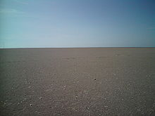
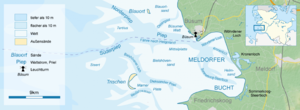
Blauort is an uninhabited high sand (outer sand ) off the German North Sea coast of Dithmarschen (near Büsum ) , which measures around 1200 m in north-south direction and 500 meters in east-west direction. It is surrounded by the Blauortsand sandbank , which is bordered by the Priel Wesselburener Loch in the north and the Piep in the south .
Like all unpaved islands and high sands on the west coast of Schleswig-Holstein, the Blauort moves steadily eastwards. From 1938 to 1962, the sand moved about 32 meters inland per year, currently the distance to the coast is about six kilometers. Blauort rises above the mean high tide (here at 1.83 m above sea level ) and is only completely flooded during spring or storm tides . There is no vegetation on Blauort. Since 1985 Blauort, which is one of the few largely natural habitats on the coast and is of great importance for sea birds and seals , has been part of protection zone 1 of the Schleswig-Holstein Wadden Sea National Park .
Blauort is marked by a beacon , the Blauortbake . In the summer months, guided mudflat hikes to Blauortsand from Büsum and Wesselburen are offered.
In January 2016 a sperm whale ran aground on Blauort. He was one of nine animals that perished on the coast in the largest sperm whale death ever recorded off Schleswig-Holstein.
The Büsum writer Stefanie Bachstein named one of her volumes of poetry Blauort .
See also
Individual evidence
- ↑ (pdf) , (p. 77) Petra Witez: GIS-supported analyzes and dynamic 3D visualizations of the morphological development of Schleswig-Holstein's tidal basins , Diss. Kiel 2002
- ↑ [1] Stephan Mai: Climate impact analysis and risk for a coastal zone using the example of the Jade-Weser region , Diss., Hannover 2004
- ↑ (html) Ecological Travel Guide Schleswig-Holstein
- ↑ Onlookers and ministers watch whale recovery. In: ndr.de. February 3, 2016, accessed February 3, 2016 .


