High servant sand
| High servant sand | ||
|---|---|---|
| Card with High Knechtsand | ||
| Waters | North Sea | |
| Geographical location | 53 ° 50 ′ N , 8 ° 22 ′ E | |
|
|
||
| Residents | uninhabited | |
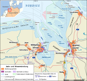
Hoher Knechtsand is a high sand in the center of the Knechtsände , an extensive sandbank area in front of the Weser and Elbe estuaries in the eastern Wadden Sea of Lower Saxony . It is located between the island of Mellum, about 16 km southwest, and the island of Neuwerk, 11 km to the northeast .
literature
- Hans-Erich Reineck, Friedrich Wunderlich: The sand bank islands Wittsand, Scharhörn and Hoher Knechtsand . In: Natur und Museum , Vol. 125 (1995), pp. 201-214, ISSN 0028-1301
- Klaus Rieger: Topography and geomorphology of the "tower island" on the Hohen Knechtsand (NSG Hoher Knechtsand) . In: Contributions to the natural history of Lower Saxony , Vol. 32 (1979), Issue 4, pp. 97-105, ISSN 0340-4277
Web links
- Bomb target (PDF; 320 kB)


