
Garbage dump Hummelsbüttel
| Garbage dump Hummelsbüttel | ||
|---|---|---|
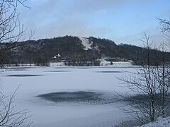
 Dump of rubbish with Hummelsee in the foreground |
||
| height | 79 m | |
| location | Hamburg , Germany | |
| Coordinates | 53 ° 40 '33 " N , 10 ° 2' 58" E | |
|
||

The Hummelsbüttel garbage dump in the Hamburg district of Hummelsbüttel is a former garbage dump , which is about 79 m above sea level. NN represents the highest elevation in the Wandsbek district. The mountain is green and serves as a place of relaxation. It is located north of the Hummelsee and the nature reserve Hummelsbütteler Moore on the southern border of Schleswig-Holstein . It offers a view of the Hamburg skyline. The residents of the north of Hamburg use it for walking and picnicking.
Mountain of garbage in winter
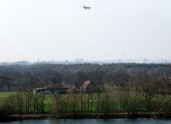
View to the south

View towards the southeast

Summit area


Emergence
In the 1960s and 1970s, sand was mined in the area of today's garbage dump. A total of three pits (Borchert 1, Herr, Borchert 2) were created at different times and were filled with a wide variety of garbage in the following years. The deposit ended in 1984. The Hummelsee was created from an unfilled part of the Borchert 2 landfill . Between 1985 and 1989 the spaces between the three landfill hills were filled. In the 1990s, there was another saddling up. As far as we know today, the deposited garbage is predominantly mineral material. In addition to soil / construction rubble, various household and commercial waste as well as industrial waste were deposited, the exact composition of which is not known.
See also
Web links
- Hummelsbüttel: Things to know and see on hamburg.de - accessed on January 21, 2017
Individual evidence
- ↑ Viktoria Keller: Poppenbüttel, portrait of a district . Ed .: Jürgen Mirow. Hamburg 2003, ISBN 3-8334-0169-9 , pp. 236 ff .
- ↑ How dangerous are the mountains of rubbish in the northern Alstertal for the population? In: Answer of the Senate to a written small question. September 6, 2013, accessed January 21, 2017 .