
List of places in Thuringia
The list of places in Thuringia contains all places in the state of Thuringia in alphabetical order.
Cities, villages and small settlements named by name (for example Allzunah ) are included. Settlements founded in the modern era (for example the Gebesee settlement southwest of the eponymous city) and city districts that did not previously exist as an "independent" location (for example Erfurt-Herrenberg ) are not included. Places that have been merged with other places to form a new place are also listed (for example Pirk and Lerchenhügel for the new place Birkenhügel ). The first column of the table contains the town, the second the municipality to which it belongs, and the third the district or urban district in which the town is located. Places with the same name are again sorted alphabetically according to the destination word ( Dörnfeld an der Heide stands before Dörnfeld an der Ilm ) and, for places without a destination word, alphabetically according to the name of the associated municipality. If this is also identical, it is sorted according to the name of the district. The list is divided into partial lists according to the first letter:
| List of places in Thuringia |
|---|
| A • B • C • D • E • F • G • H • I • J • K • L • M • N • O • P • Q • R • S • Sch • T • U • V • W • Z) |
Settlement geography and history

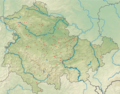
In Thuringia there are a total of about 3500 places, which in relation to the area of the country is about 4.5 square kilometers (450 hectares) per place or about 22 places per 100 square kilometers. The local density varies considerably between two parts of the country. In the entire west of Thuringia, roughly west of an approximate line Naumburg - Ilmtal - Ilmenau - Coburg , relatively large, closed settlements dominate at a great distance from one another, partly in corridors of over 1000 hectares, while to the east of it smaller, but denser settlement structures with numerous, closely spaced structures Villages predominate on local corridors of sometimes less than 200 hectares. While the west of the country can be counted as part of the Germanic old settlements , the east was only included in the high Middle Ages as part of the German settlement in the east . The Slavic population living there was assimilated, whereby a continuity of settlement continued and the different structures were taken over by the settlers and are still visible today.
The closed village dominates in Thuringia, while isolated and scattered settlements occur only locally. There are often isolated settlements in the Wartburg district and in the Rhön in the west of the country and scattered settlements are most likely to be found east of the White Elster in the district of Greiz and in the Altenburger Land .
In the historical (pre-modern) city network of the state, the dichotomy is also reflected, so there are only a few, but relatively large cities, especially in the middle and north-west of the country (between the cities of Erfurt , Eisenach and Mühlhausen, which are 50 kilometers apart, are Gotha and Bad Langensalza only two other and no small towns), while the urban density increases towards the southeast and the size of the individual towns decreases. In the upper Saale region, for example, there are eleven cities southeast of Saalfeld to the state border, of which Schleiz is by far the largest with 8,000 inhabitants.
Place names
Slavic names
Place names of Germanic and Slavic origin can be found in Thuringia , the latter only to be found east of a line Naumburg - Ilmtal - Ilmenau - Coburg and dating from the Slavic settlement period (7th - 10th centuries). In the most favorable settlement areas of this region (valleys of Saale , Wethau and Weißer Elster , Orlasenke and Altenburger Land ), old Slavic place names make up the majority, while the high altitudes and low-yield soils remained uninhabited at that time. In the east of Thuringia there is mainly the Slavic ending -ic, which has been converted to various suffixes , such as -itz (-witz, -nitz, -litz), -ütz (-mütz, -schütz) or softened forms such as -itsch and - itzsch. The few Slavic place names with the ending -ov were usually changed to -au in language development. However, not all place names on -au have this origin, as they can also refer to a floodplain. South of the Thuringian Forest there is a small group of places auf -wind with German personal names in the qualifier, which (as in Upper Franconia ) go back to Slavic settlers ( Bavaria Slavica ) who were settled there by German landlords ( e.g. Poppenwind and Almerswind ). The suffix -wind can also be related to clearing, but the ending -reuth is predominant in clearing locations in this area.
In central Thuringia, where the Germanic and Slavic settlement areas overlapped in a wide corridor between Gera and Saale to the north and between Hildburghausen and Sonneberg to the south of the Thuringian Forest , some German and Slavic settlements existed side by side, which were given the same name (from the German side). Starting from the medieval name Wenden , prefixes were formed for the Slavic places such as Windisch- (about Windischholzhausen and Mönchenholzhausen east of Erfurt) and Wenigen- ( Jena on the west and Wenigenjena on the east bank of the Saale), the latter partly in the written Latin language of the time were translated with minor and returned to German as Klein- and thus a small part of the places on Klein- form (such as the large street village Großschwabhausen and the neighboring round-like Kleinschwabhausen near Jena with their very different settlement structures).
Germanic and German names
The oldest toponyms are derived from river names and are relatively diverse in their current appearance. B. Gera, Jena, Gotha and Eisenach are counted. More recent formations with reference to waters are then called -bach and were productive until the end of the Middle Ages. Among the actual place names of Germanic and later German origin in Thuringia those on -leben and -städt / stedt / stadt are the oldest, as these are almost exclusively in the most favorable locations of the old settlements in the Thuringian basin and its peripheral valleys. The -stedt names remained productive a little longer than the -leben names and are therefore also found in less favorable locations that were settled a little later. Many of these places can go back to the 6th century, about 200 years before the written tradition of place names in the country began. A number of characteristic group locations in the Thuringian Basin from this period, such as the Engel locations or the summer locations , met with lively research interest in the history of settlement . The next layer is represented by the names on -ingen / ungen and -heim , which belong to the Frankish conquest . Coming from the southwest, it reached Thuringia in the 7th century and led to the colonization of the Rhön , the upper Werra valley , the grave field and the better locations of the Eichsfeld .
At the transition to the medieval development of the country in the Holy Roman Empire are the -hausen and -feld locations, a layer of names with long productivity, which can therefore be assigned to both phases, with the -hausen locations tending to be at the better settlement points, the -feld -Places in the less favorable. Especially in the Rhön and the upper Werra valley, genitive names that have lost their ending appear during this period (e.g. Birx or Melkers , Melpers and Metzels ). The most recent stratum to be fully located in the state development are on the one hand the clearing names , starting with the -rode locations in the less favorable locations of Eichsfeld and southern Harz via the -roda locations in the foreland of the Thuringian Forest, the Franconian -reuth locations to the green locations in Vogtland . The -rieth locations in the area of drained swamps and floodplains are also part of this. On the other hand, the village names that became productive in Thuringia relatively late (compared to the Rhineland, for example ) form an essential part of the youngest name layer. They occur primarily in unfavorable settlement areas in the old settlement area and at the same time form the largest part of the areas newly created in the course of the eastern settlement . In this region, too, they are mainly found in unfavorable locations that were previously unpopulated, such as the Holzland , the Slate Mountains and the Upper Vogtland. These names were formed very uniformly (with a personal name in the final word and the ending -dorf), which is why there are some very common in a small area, about six places called Burkersdorf and six places called Waltersdorf .

Life places (oldest settlement areas)
Stedt-Orte (old settlement areas)

Ingen, Ungen and Heim locations (Franconian colonization)

House and field locations (Franconian and medieval colonization)
Itz-Orte (old Slavic settlements)
Clearance sites (medieval inland colonization)

Village places (medieval east and inland colonization)


Desolation
In Thuringia, there are numerous deserted villages and small settlements that are spread over the entire area. In the late Middle Ages and early modern times in particular, many places fell into desolation, often shortly after they were founded. In the period after the Thirty Years' War, only a few places fell into desolation, also because almost no new settlements were founded.
medieval and early modern desolations of Thuringia:
- Enzenrode at today's Hohenfelden reservoir
- Köttendorf , partial desertification with a tower hill castle
Desolations of the 20th century in Thuringia are:
- in the area of open- cast lignite mining near Meuselwitz : Leesen , Petsa , Ruppersdorf and Rusendorf
- in the area of the uranium mining south of Ronneburg : Culmitzsch , Gessen , Katzendorf and Schmirchau
- in the area of the former inner-German border: Billmuthausen , Dornholz , Erlebach , Kaulsroth , Kleintöpfer , Korberoth , Leitenhausen , Liebau , Schwenge and other settlements
- in the area of dams: Leibis and Preßwitz
- in the area of military training areas: Heerda and Tambuchshof near Ohrdruf; Ihlefeld and Heßwinkel im Hainich .
literature
- Friedhelm Debus : onomatology and history of names. An introduction. Erich Schmidt Verlag, Berlin 2012, ISBN 978-3503137183 .
See also
Altenburger Land | Eichsfeld | Eisenach | Erfurt | Gera | Gotha | Greiz | Hildburghausen | Ilm district | Jena | Kyffhäuserkreis | Nordhausen | Saale-Holzland district | Saale-Orla district | Saalfeld-Rudolstadt | Schmalkalden-Meiningen | Sömmerda | Sonneberg | Suhl | Unstrut-Hainich Circle | Wartburg district | Weimar | Weimar Country
Complete list : List of places in Thuringia