Almerswind
|
Almerswind
City of Schalkau
|
|
|---|---|
| Coordinates: 50 ° 22 ′ 14 ″ N , 11 ° 0 ′ 36 ″ E | |
| Height : | 363 m above sea level NN |
| Residents : | 257 |
| Incorporation : | June 30, 1994 |
| Postal code : | 96528 |
| Area code : | 036766 |
|
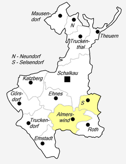
Location of Almerswind in Schalkau
|
|
|
Former school
|
|
Almerswind is a district of Schalkau in the Sonneberg district in Thuringia .
location
Almerswind is located south of Schalkau on state road 1112 and on the border with Bavaria . The area around Schalkau is located on the southern slope of the Thuringian Slate Mountains in the valley of the Upper Itz . In a westerly direction you come to the nature reserve Magerrasen near Emstadt and the Itzaue . In the place the Grümpen flows into the Itz.
history
The village was first mentioned in documents in 1275. Other sources name the year 1291. The core of the castle, a tower hill castle, dates from the late Middle Ages. It was extensively rebuilt in the GDR and used as a community office and kindergarten. In 2001 it was bought by Baron von Hoyningen-Huene . In 1853 there were three mills. A school was built in 1857, an extension followed in 1935 and it was closed in 1970. From 1950 to 1989 the place was a restricted area.
In 2012, a total of 259 people lived in the agricultural, forestry and touristic village. In 1910 the place had 268 and 1939 292 inhabitants. The guild tree is back with all the guild signs. From 1923 to 1932 Almerswind was merged with Roth and Selsendorf to form the community of Roth-Almerswind. Selsendorf was incorporated again on July 1, 1950 and on June 30, 1994 Almerswind was incorporated into Schalkau.
Attractions
- Almerswind Castle is a small country castle.
- The Grümpentalbrücke spans two kilometers north of Almerswind the district road 34 from Grümpen to Almerswind in a length of 1104 meters.
dialect
Itzgründisch , a Main Franconian dialect, is spoken in Almerswind .
Individual evidence
- ^ Wolfgang Kahl : First mention of Thuringian towns and villages. A manual. 5th, improved and considerably enlarged edition. Rockstuhl, Bad Langensalza 2010, ISBN 978-3-86777-202-0 , p. 15.
- ↑ Information sign on the village square
- ↑ History of Almerswind Castle on a private website . Retrieved April 19, 2012.
- ↑ gemeindeververzeichnis.de
- ^ Michael Rademacher: German administrative history from the unification of the empire in 1871 to the reunification in 1990. sonneberg.html. (Online material for the dissertation, Osnabrück 2006).
- ^ The place on the website of the city of Schalkau. Retrieved June 21, 2020 .
- ↑ Thomas Schwämmlein: Double names shaped the first reform . In: Free Word , February 14, 2013
- ^ Thuringian State Office for Statistics: Area changes: Municipality 72015 Schalkau, city


