Gundelswind
|
Gundelswind
City of Schalkau
Coordinates: 50 ° 24 ′ 51 ″ N , 10 ° 59 ′ 48 ″ E
|
||
|---|---|---|
| Height : | 470 m | |
| Incorporation : | July 1, 1950 | |
| Incorporated into: | Bachfeld | |
| Postal code : | 96528 | |
| Area code : | 036766 | |
|
Location of Gundelswind in Thuringia |
||
|
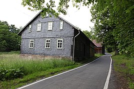
Stable house from 1880
|
||
Gundelswind is a hamlet of Bachfeld , a district of Schalkau in the Sonneberg district in Thuringia .
location
The hamlet of Gundelswind is located north of Bachfeld in a side valley of the Itz, on county road 24. To the west and east, the slopes on the hills are wooded. In the east the vineyard rises to a height of 510 m. The slope of the Thuringian Slate Mountains begins further north . Schalkau is to the south . There is a connection to Landesstraße 1112 .
history
The hamlet was first mentioned in a document in 1358/1362 ( in the Regeste Schaumberg II 127 ).
On December 31, 2019, the Bachfeld community was incorporated into Schalkau.
Web links
Commons : Gundelswind - collection of images, videos and audio files
Individual evidence
- ↑ Wolfgang Kahl : Thuringian Association of the Persecuted of the Nazi Regime - Association of Antifascists and Study Group of German Resistance 1933–1945 (Ed.): Local history guide to sites of resistance and persecution 1933–1945. Volume 8: Thuringia. VAS - Verlag für Akademische Schriften, Frankfurt am Main 2003, ISBN 3-88864-343-0 , p. 106.

