Selsendorf
|
Selsendorf
City of Schalkau
Coordinates: 50 ° 22 ′ 59 ″ N , 11 ° 1 ′ 34 ″ E
|
|
|---|---|
| Residents : | 35 (2012) |
| Incorporation : | July 1, 1950 |
| Incorporated into: | Almerswind |
| Postal code : | 96528 |
| Area code : | 036766 |
|
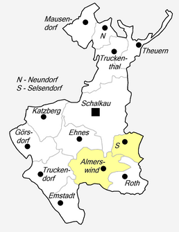
Location of Selsendorf in Schalkau
|
|
|
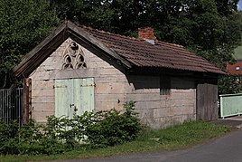
Bakery in Selsendorf
|
|
Selsendorf is a hamlet-like part of Almerswind , a district of Schalkau in the Sonneberg district in Thuringia .
location
Selzendorf is located southeast of Schalkau on the district road 34 with a connection at Grümpen to the federal road 89 . Almerswind is located to the south and is a municipal partner. The area around Schalkau lies on the southern slope of the Thuringian Slate Mountains in the Upper Itz valley .
history
The village was first mentioned in 1516. From 1923 to 1932 Selsendorf was merged with Roth and Almerswind to form the community of Roth-Almerswind. On July 1, 1950, Selsendorf came back to Almerswind. On June 30, 1994, Selsendorf was incorporated with Almerswind to Schalkau. 35 people live in the hamlet. The Schalkau agricultural cooperative looks after sheep there.
dialect
Itzgründisch , a Main Franconian dialect, is spoken in Selsendorf .
Individual evidence
- ^ Wolfgang Kahl : First mention of Thuringian towns and villages. A manual. 5th, improved and considerably enlarged edition. Rockstuhl, Bad Langensalza 2010, ISBN 978-3-86777-202-0 , p. 262.
- ↑ Thomas Schwämmlein: Double names shaped the first reform. In: Free Word , February 14, 2013.
- ^ Thuringian State Office for Statistics: Area changes: Municipality 72015 Schalkau, city
- ^ Website of the city of Schalkau 2012

