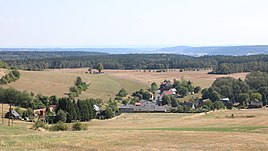
Mausendorf (Schalkau)
|
Mausendorf
City of Schalkau
Coordinates: 50 ° 26 ′ 3 ″ N , 10 ° 59 ′ 51 ″ E
|
|
|---|---|
| Height : | 542 m above sea level NN |
| Incorporation : | June 1, 1992 |
| Postal code : | 96528 |
| Area code : | 036766 |
|
Location of Mausendorf in Schalkau
|
|
Mausendorf and Neundorf are a hamlet-like district of Schalkau in the Sonneberg district in Thuringia .
location
Mausendorf and the neighboring town of Neundorf are in the western part of the Sonneberg district on the border with Hildburghausen . The districts are located at the foot of the Bleßberg directly in the Schalkau Plateau , on the edge of the Thuringian Forest and the Thuringian Slate Mountains . The state road 2094 and the district roads 11 and 528 cover the hamlet in terms of traffic.
history
The hamlet was first mentioned in a document in 1516. 40 residents live in the village. In 1910 the place had 79 and in 1939 89 inhabitants.
On July 1, 1950, the previously independent municipality of Neundorf was incorporated.
On June 1, 1992, Mausendorf was incorporated into Schalkau.
dialect
Itzgründisch , a Main Franconian dialect, is spoken in Mausendorf .
Individual evidence
- ^ Wolfgang Kahl : First mention of Thuringian towns and villages. A manual. 5th, improved and considerably enlarged edition. Rockstuhl, Bad Langensalza 2010, ISBN 978-3-86777-202-0 , p. 177.
- ↑ The location on the website of the city of Schalkau. Accessed on April 21, 2012
- ↑ gemeindeververzeichnis.de
- ^ Michael Rademacher: German administrative history from the unification of the empire in 1871 to the reunification in 1990. District of Sonneberg. (Online material for the dissertation, Osnabrück 2006).
- ^ Thuringian State Office for Statistics: Area changes: Municipality 72015 Schalkau, city

