List of administrative units in Bremen
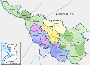
The first reorganization of the geographical administrative division of the city of Bremen after the Second World War was carried out in 1946. Numerous formerly non-Bremen municipalities such as Strom, Blockland or Borgfeld were also incorporated and declared to be districts.
The structure of the administrative units in Bremen was then redefined by two ordinances of February 22 and February 23, 1951, with fewer administrative units at that time.
The list of administrative units in Bremen reflects the current structure
- the 5 city districts north, west, center, south and east as purely administrative units, which are listed in a small preceding table.
- the 19 districts , each of which (except for ports ) has its own district council.
- the 88 districts ; Of these, four districts are directly assigned to a district, i.e. without the district level. Only these four districts have a district advisory board.
Due to the changed use of the overseas port area, the administrative districts of the city of Bremen were reorganized by the local law of March 24, 2009 (BremGBl p. 93). The changes in detail:
- The district 121 "commercial ports" is omitted. It will be spun off from the Häfen district and the Mitte district.
- From this the new district 437 Überseestadt is formed. It is part of the Walle district in the West district.
The highest political body in the individual city or districts is the district or local council , which is made up of politically active, voluntary citizens. These appoint a speaker and a deputy speaker from among their ranks. Since 1991, the advisory council elections have usually taken place parallel to the citizenship elections. The most recent were held on May 10, 2015, at the same time as the 2015 state elections in Bremen . The advisory boards function as district or district parliaments and have limited decision-making options. You manage district-related finances and coordinate, for example, building projects. In addition, inquiries, wishes and suggestions from the population are brought up and discussed in the advisory boards. In certain cases the Senate has to hear the advisory councils and is not allowed to decide over them.
Townships
The city districts are sorted according to their key numbers.
- City district: states the city district that is dealt with in the corresponding line and its key number.
- City or districts: Name the individual city or districts of the city district.
- Area: Indicates the total area of the city district in square kilometers as of December 31, 2009.
- Population: Indicates the total population of the city district as of December 31, 2008.
- Population density: gives the average number of inhabitants per square kilometer in the municipality.
- Map: Illustrates the location of the city district in the city of Bremen.
| Borough | City or districts | surface | Residents | Population density | map |
|---|---|---|---|---|---|
|
Middle of 1 |
33.741 km² | 17,392 |
515 inhabitants / km² |

|
|
|
South 2 |
66.637 km² | 123.303 |
1,850 inhabitants / km² |

|
|
|
East 3 |
108,201 km² | 218.843 |
2,023 inhabitants / km² |

|
|
|
West 4 |
56.606 km² | 89,216 |
1,576 inhabitants / km² |

|
|
|
North 5 |
60.376 km² | 98,606 |
1,633 inhabitants / km² |

|
Districts
The districts are sorted according to their key numbers. These are officially four digits, but the fourth digit is actually always zero. The key numbers are structured hierarchically: the first digit denotes the city district, the second digit the district and the third digit the district.
- District: Names the district that is dealt with in the corresponding line and its key number.
- Districts: Names the individual districts of the district with the associated key numbers.
- Area: Indicates the total area of the district in square kilometers on December 31, 2013.
- Population: Indicates the total population of the district on December 31, 2013.
- Population density: states the average number of inhabitants per square kilometer in the district.
- Advisory board spokesman: Name the advisory board spokesperson and the deputy advisory board spokesperson for the district.
- K: Name the geographic coordinates on which the district is located and with the help of which it can be found on a map. These can be called up via a link that leads to various display options.
- Map: Shows the location of the district in the city of Bremen.
| district | Districts | surface | Residents | Population density | Advisory Board Spokesman Deputy Advisory Board Spokesman |
K | map |
|---|---|---|---|---|---|---|---|
|
Mid 11th |
|
3.236 km² | 17,136 |
5,295 inhabitants / km² |
Michael Rüppel (Greens) Holger Ilgner (SPD) |
|

|
|
Ports 12 |
|
30.505 km² | 147 |
5 inhabitants / km² |
No own advisory board. Industrial ports in the advisory board area Gröpelingen, Neustädter Häfen and Hohentorshafen in the advisory board area Woltmershausen. |
|

|
|
Neustadt 21 |
|
15.319 km² | 43,241 |
2,823 inhabitants / km² |
Jens Oppermann (SPD) Ingo Mose (Greens) |
|

|
|
Obervieland 23 |
|
13.855 km² | 35,464 |
2,560 inhabitants / km² |
Stefan Markus (SPD) Ewald Stehmeier (CDU) |
|

|
|
Huchting 24 |
|
13.729 km² | 29,166 |
2,124 inhabitants / km² |
Falko Bries (SPD) Yvonne Averwerser (CDU) |
|

|
|
Woltmershausen 25 |
|
5.386 km² | 13,878 |
2,577 inhabitants / km² |
Edith Wangenheim (SPD) Christopher Mendik (Greens) |
|

|
|
26th |
|
11.079 km² | 1.107 |
100 inhabitants / km² |
Ralf Hagens (CDU) Linda Warnken (SPD) |
|

|
|
27 |
|
7.269 km² | 447 |
61 inhabitants / km² |
Lisa Imhoff (CDU) Silke Ruge-Hemmelskamp (SPD) |
|

|
|
Eastern suburb 31 |
|
3.337 km² | 29,740 |
8,912 inhabitants / km² |
Steffen Eilers (Greens) Daniel de Olano (SPD) |
|

|
|
Bogus 32 |
|
8.751 km² | 37,845 |
4,325 inhabitants / km² |
Barbara Schneider (Greens) Stefan Pastoor (SPD) |
|

|
|
Vahr 33 |
|
4,343 km² | 27.091 |
6,238 inhabitants / km² |
Bernhard Siegel (SPD) Tim Haga (CDU) |
|

|
|
Horn-Lehe 34 |
|
14.038 km² | 24,393 |
1,738 inhabitants / km² |
Stefan Quaß (CDU) Catharina Hanke (SPD) |
|

|
|
35 |
|
16.627 km² | 7,771 |
467 inhabitants / km² |
Karl-Heinz Bramsiepe (CDU) Bernd Vahlenkamp (SPD) |
|

|
|
Oberneuland 36 |
18.442 km² | 12,906 |
700 inhabitants / km² |
Tamina Kreyenhop (CDU) Waltraut Wedemeyer (FDP) |
|

|
|
|
Osterholz 37 |
|
12.894 km² | 37,476 |
2,906 inhabitants / km² |
Wolfgang Haase (SPD) Ralf Dillmann (Greens) |
|

|
|
Hemelingen 38 |
|
29.769 km² | 41,621 |
1,398 inhabitants / km² |
Uwe Jahn (SPD) Heinz-Hermann Hoffhenke (CDU) |
|

|
|
41 |
|
30,300 km² | 418 |
14 inhabitants / km² |
Gerd Gartelmann (CDU) Henning Garbade (SPD) |
|

|
|
Findorff 42 |
|
4.277 km² | 26,071 |
6,096 inhabitants / km² |
Gönül Bredehorst (SPD) Anja Wohlers (Greens) |
|

|
|
Wall 43 |
|
12.238 km² | 27,672 |
2,261 inhabitants / km² |
Wolfgang Golinski (SPD) Cecilie Eckler-von Gleich (Greens) |
|

|
|
Groepelingen 44 |
|
9.791 km² | 35,055 |
3,580 inhabitants / km² |
Dieter Adam (SPD) Raimund Gaebelein (Die Linke) |
|

|
|
Burglesum 51 |
|
25.825 km² | 33,057 |
1,280 inhabitants / km² |
Martin Hornhues (CDU) Stefan Besecke (SPD) |
|

|
|
Vegesack 52 |
|
11.917 km² | 33,998 |
2,853 inhabitants / km² |
Jürgen Hartwig (SPD) Thomas Pörschke (Greens) |
|

|
|
Blumenthal 53 |
|
22.634 km² | 31,551 |
1,394 inhabitants / km² |
Ute Reimers-Bruns (SPD) Hans-Gerd Thormeier (CDU) |
|

|
Local offices
There are 17 local offices in Bremen. Four of them are responsible for several advisory boards:
- Blockland local office
- Blumenthal local office
- Borgfeld local office
- Burglesum local office
- Local office Hemelingen
- Local office Horn-Lehe
- Local office Huchting
- Local office Mitte / Ostliche Vorstadt (Advisory Councils Mitte and Ostliche Vorstadt)
- Neustadt / Woltmershausen local authority (Neustadt and Woltmershausen advisory boards)
- Oberneuland local office
- Obervieland local office
- Osterholz local office
- Local office Schwachhausen / Vahr (Advisory Boards Schwachhausen and Vahr)
- Seehausen local office
- Local electricity office
- Vegesack local office
- Local Office West (Advisory Boards Findorff, Walle and Gröpelingen)
Individual evidence
- ↑ Structure of the urban area in the administrative district reorganization ordinance
- ↑ a b Bremen small-scale, area on December 31, 2013. In: statistik-bremen.de. Bremen State Statistical Office, accessed on June 5, 2015 .
- ↑ a b Bremen small-scale, population on December 31, 2013. In: statistik-bremen.de. Bremen State Statistical Office, accessed on June 5, 2015 .
- ↑ a b The figures from the State Statistical Office cannot be used here directly. The area of 22.695 km² for the district of harbors and 25.931 km² for the city district of Mitte is given in Bremen on a small scale “without the Bremerhaven overseas port area”. Therefore, 7.81 km² according to the Statistical Yearbook 2009 (PDF file; 3.8 MB), p. 9 has been added.
- ↑ https://www.weser-kurier.de/bremen/bremen-stadt_artikel,-antifaschist-und-ortspolitiker-raimund-gaebelein-gestorben-_arid,1921171.html?fbclid=IwAR2KVrWeeMwW02tTiUcY9eRvXdxlNv6hzRknzdw9sp
See also
- List of administrative levels in Bremerhaven
- Allocation of seats in the advisory boards of Bremen
- History of the city of Bremen # Incorporation
literature
- Herbert Black Forest : The Great Bremen Lexicon . 2nd, updated, revised and expanded edition. Edition Temmen, Bremen 2003, ISBN 3-86108-693-X .
Web links
- Official website of the city of Bremen
- Presentation of the individual districts on the official website of Bremen
- Local law on advisory boards and local offices. Transparency portal of the Free Hanseatic City of Bremen, accessed on July 14, 2017 .
- Link catalog on the subject of Bremen districts at curlie.org (formerly DMOZ )

