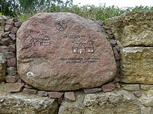
Petsa
The deserted village Petsa is by open pit Zechau abgebaggertes village (Gertrud III) to the district Zechau the community Kriebitzsch in Altenburger Land in Thuringia belongs.
Geographical location
Petsa was south of Zechau and west of Altenburg . Other neighboring towns were Kröbern in the east, Monstab in the southeast and Großröda in the west. The remaining hole in Zechau is now northwest of the locality, another lake southwest of Petsa. Petsa's corridor is now used for agriculture.
history
The village of Petsa was first mentioned in a document from 1181 to 1214. The place name of Petsa is Slavic and is derived from the personal name "Putes". The place belonged to the Wettin office of Altenburg , which was under the sovereignty of the following Ernestine duchies from the 16th century due to several divisions in the course of its existence : Duchy of Saxony (1554 to 1572), Duchy of Saxony-Weimar (1572 to 1603), Duchy of Saxony- Altenburg (1603 to 1672), Duchy of Saxe-Gotha-Altenburg (1672 to 1826). When the Ernestine duchies were reorganized in 1826, the place came back to the duchy of Saxony-Altenburg.
Around 1850 the agricultural Petsa had around 130 inhabitants. Not far from the village there was a windmill on a hill. After the administrative reform in the Duchy of Saxony-Altenburg, Petsa belonged to the Eastern District (until 1900) and to the Altenburg District Office (from 1900). From a legal point of view, the village was under the Altenburg District Court since 1879 and the Meuselwitz District Court from 1906 . From 1918 Petsa belonged to the Free State of Saxony-Altenburg , which was added to the State of Thuringia in 1920. In 1922 the place was incorporated into the Altenburg district. Zechau, Leesen and Petsa merged in 1923 to form the municipality of Zechau-Leesen .
Lignite mining around Petsa, located in the south of the Meuselwitz-Altenburg lignite mining area , began around 1900. Underground pits were "Grube Gertrud No. 131" in the north of the village and "Grube Eugen No. 132" in the west and south. In the open-cast mine , the coal was first extracted from the "Eugen opencast mine" to the west (1911 to 1915). In 1914 the "" Tagebau Gertrud II "(also: Tagebau Petsa) opened, which dredged the area south of Petsa without touching the place until 1932. The open pit Gertrud III (Zechau) , opened in 1931 , gradually approached the agricultural village From the east. After the fulcrum was relocated to the north of Petsa in 1943/44, most of the 350 inhabitants were resettled to a specially built district in Kriebitzsch by 1947. In the early 1950s, this fate also met Leesen and part of Zechau. After the open-cast mine was shut down in 1959, the now renatured Zechau hole was created in the area of Leesen. Today it is a nature reserve of great ecological importance within the mining landscape south of Leipzig. The former Petsa corridor is used for agriculture.
Personalities
- Alban Köhler (born March 1, 1874 in Petsa, † February 26, 1947 in Niederselters ), radiologist
See also
Web links
Individual evidence
- ^ Wolfgang Kahl: First mention of Thuringian towns and villages. A manual. Verlag Rockstuhl, Bad Langensalza, 2010, ISBN 978-3-86777-202-0 , p. 217
- ↑ The locations of the Altenburg district in the Google book search, from p. 83
- ↑ The eastern district of the Duchy of Saxony-Altenburg in the municipal directory 1900
- ^ The Altenburg district office in the municipality register 1900
- ^ Zechau-Leesen in the Thuringia archive portal
Coordinates: 51 ° 0 ′ 0 ″ N , 12 ° 19 ′ 59.9 ″ E

