
Birx
| coat of arms | Germany map | |
|---|---|---|
 Help on coat of arms |
Coordinates: 50 ° 32 ' N , 10 ° 3' E |
|
| Basic data | ||
| State : | Thuringia | |
| County : | Schmalkalden-Meiningen | |
| Management Community : | High Rhön | |
| Height : | 740 m above sea level NHN | |
| Area : | 2.77 km 2 | |
| Residents: | 162 (Dec. 31, 2019) | |
| Population density : | 58 inhabitants per km 2 | |
| Postal code : | 98634 | |
| Area code : | 036946 | |
| License plate : | SM, MGN | |
| Community key : | 16 0 66 012 | |
| LOCODE : | DE 7BO | |
| Address of the municipal administration: |
Seifertser Str. 15 98634 Birx |
|
| Website : | ||
| Mayor : | Steffen Hohmann (shared flat Birx) | |
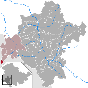
| Location of the municipality of Birx in the district of Schmalkalden-Meiningen | ||
  |
||

Birx is a municipality in the Schmalkalden-Meiningen district in Thuringia . It belongs to the administrative community Hohe Rhön , which has its administrative headquarters in the city of Kaltennordheim . The Birxgraben is named after her.
geography
Birx is located in the extreme south-western corner of Thuringia, only 1 km from the border triangle Thuringia - Hesse - Bavaria . The distance from the place to the former inner-German border is only 0.2 km.
The place lies on the southern slope of the high plateau between the elevations Dungberg (773 m) and Grabenberg (796 m). The stream of the Birxgraben rises in several springs near the village.
Neighboring communities
In the northeast is the Thuringian village of Frankenheim , on the Hessian side in the Ulstertal u. a. the Ehrenberg districts Melperts , Seiferts and Thaiden , on the Bavarian side in the southeast the city of Fladungen with its districts.
history
Birx was mentioned in a document as early as 783. According to local tradition, St. Boniface from Fulda is said to have established the place. The 750 m high place was probably called "Perkühes" (mountain house) during the founding period. Later in the 9th century the name appears somewhat changed as "Percuhis". According to ancient traditions, Count Berthold von Henneberg bought forests, meadows and paths along with interest from the Würzburg chapter for 150 Heller in 1302. The place came in 1569 through a comparison to the office of Kaltennordheim of the county of Henneberg , later it belonged to the duchy of Saxony-Weimar-Eisenach . Between 1500 and 1806 the place was in the Franconian Empire .
Birx had belonged to the Eisenacher Oberland since 1815 and was one of the most remote places in the Grand Duchy of Saxony-Weimar-Eisenach. The church in Birx was built in 1870 in the neo-Romanesque style from red sandstone. The "Birxmühle" was a stately grinding mill, about 800 m southwest of the Birx location on the Thuringian side of the state border. In 1961 the last owner was expropriated and had to leave the place, in 1962 the building was demolished. Opposite the mill, on the Hessian side of the border, a stone cross reminds of a murder committed there centuries ago.
Until the turn of 1989, the place was surrounded on three sides at an acute angle by the GDR border installations and only had access to the GDR to the northeast .
politics
Municipal council
The council consists of the mayor and 6 other elected council members.
- Voting community Birx 6 seats
(Status: local elections from May 25, 2014)
mayor
Steffen Hohmann (WG Birx) was elected honorary mayor for the first time on June 6, 2010 with 79.8% of the votes and was re-elected in 2016.
Picture gallery
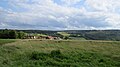
Birx from the northwest

Seifertser Str. To the south

The neo-Romanesque church of the place

Interior of the church, pulpit and altar

Interior view of the church, gallery with organ
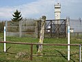
GDR border installations on the Grabenberg


religion
In Birx, a neo-Romanesque Evangelical Martin Luther Church was built from sandstone blocks. The church building is at Seifertser Straße 13. It is a branch church of Frankenheim .
After the 17th century a small wooden church was built, which was replaced by today's neo-Romanesque stone church in 1870. The top of the spire is hexagonal with a head and a cross.
Culture and sights
Buildings
Martin Luther Church After the 17th century a small wooden church was built, which was replaced in 1870 by today's neo-Romanesque stone church. The top of the spire is hexagonal with a head and a cross.
Monuments
The remnants of the border fortifications on a hill near the state border are known as a memorial to German history .
Natural monuments
To the south-east of the village is the Black Moor on the Bavarian side , as is the Birxgraben .
traffic
The place is on the L1123 (referred to as L3476 on the Hessian side) between Seiferts (about three kilometers to the west) and Frankenheim / Rhön (about two kilometers to the northeast).
literature
- Walter Höhn: Thuringian Rhön. Cities, villages and landscapes between Werra and Ellenbogen. Michael Imhof, Petersberg 2005, ISBN 3-86568-060-7 , p. 124 f.
Web links
- Information about Birx at vgem-hoherhoen.de, accessed on October 3, 2017
Individual evidence
- ^ Population of the municipalities from the Thuringian State Office for Statistics ( help on this ).
- ↑ HH Hadanczick: The Birxmühle, a victim of the border fortifications . In: Rhönwacht . 1994, ISSN 0936-1723 , pp. 40 .
- ↑ 2014 municipal council elections in Thuringia - final result: Birx , accessed on June 6, 2017
- ↑ Mayoral elections 2016 in Thuringia , accessed on October 3, 2017

Belrieth | Birx | Breitungen / Werra | Brotterode-Trusetal | Christes | Dillstädt | Einhausen (Thuringia) | Ellingshausen | Erbenhausen | Fambach | Flea Seligenthal | Frankenheim / Rhön | Friedelshausen | Grabfeld | Kaltennordheim | Kühndorf | Leutersdorf (Thuringia) | Mehmels | Meiningen | Neubrunn (Thuringia) | Oberhof | Ober Maßfeld-Grimmenthal | Oberweid | Rhönblick | Rippershausen | Ritschenhausen | Pipe | Pink | Roßdorf (Thuringia) | Schmalkalden | Surge | Schwarza (Thuringian Forest) | Steinbach-Hallenberg | Sülzfeld | Undersize field | Utendorf | Vachdorf | Wasungen | Zella Mehlis