
Rhönblick
| coat of arms | Germany map | |
|---|---|---|
 Help on coat of arms |
Coordinates: 50 ° 34 ' N , 10 ° 16' E |
|
| Basic data | ||
| State : | Thuringia | |
| County : | Schmalkalden-Meiningen | |
| Height : | 437 m above sea level NHN | |
| Area : | 78.72 km 2 | |
| Residents: | 2655 (Dec. 31, 2019) | |
| Population density : | 34 inhabitants per km 2 | |
| Postal code : | 98617 | |
| Primaries : | 036943, 036945 (Gleimershausen, Haselbach, Hermannsfeld) | |
| License plate : | SM, MGN | |
| Community key : | 16 0 66 093 | |
| Community structure: | 10 districts | |
| Address of the municipal administration: |
Marktgasse 106 98617 Rhönblick |
|
| Website : | ||
| Mayor : | Christoph Friedrich (Free Voters) | |
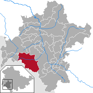
| Location of the municipality of Rhönblick in the district of Schmalkalden-Meiningen | ||
  |
||

Rhönblick is a municipality in the Rhön in the Schmalkalden-Meiningen district in the Franconian south of Thuringia . Its head office is located in the Helmershausen district .
geography
Districts (in brackets: population figures)
- Bettenhausen (820)
- Geba (90)
- Gerthausen (224)
- Gleimershausen (60)
- Haselbach (71)
- Helmershausen (652)
- Hermannsfeld (318)
- Seeba (127)
- Stedtlingen (507)
- Thurmgut (50)
- Wohlmuthausen (247)
history
In the districts of Bettenhausen, Hermannsfeld, Seeba and Stedtlingen there were persecutions of witches from 1603 to 1681 . A total of 41 people were indicted and 21 executed in these witch trials .
The municipality of Rhönblick was formed on August 1, 1996 by ordinance of the Interior Minister of the State of Thuringia. The communities of Gerthausen, Helmershausen and Wohlmuthausen had previously been merged into the Rhönblick administrative community .
Population development
Development of the population:
|
|
|
|
- Data source: from 1994 Thuringian State Office for Statistics - values from December 31st
politics
Municipal council
The municipal council election on May 25, 2014 , with a turnout of 70.0%, led to the following result for the composition of the municipal council:
| Party / list | Share of votes | Seats |
| CDU | 10.7% | 1 |
| left | 4.1% | 1 |
| Free voters Rhönblick | 10.8% | 2 |
| PRO Rhönblick | 23.7% | 3 |
| Free voters Bettenhausen | 21.8% | 3 |
| Electoral Association. Stedtlingen | 21.0% | 3 |
| Free voters Wohlmuthausen | 8.0% | 1 |
mayor
On November 2, 2014 Christoph Friedrich was elected the new mayor of the Rhönblick community with 84.1% of the valid votes. The turnout was 37.4%.
photos

Gerthausen from the south
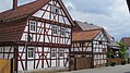
Half-timbered houses in Helmershausen

Marktgasse in Helmershausen

Helmershausen from the south
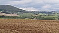
Wohlmuthausen from the southwest


Culture and sights
Buildings
- Hutsburg near Helmershausen
- Rhön Cathedral (Church), Helmershausen
- Fortified church "Zum Heiligen Kreuz" with curtain wall and Gadengebäuden , Bettenhausen
- Rectory (inherited from 1541), Bettenhausen
- Black Castle, Yellow Castle and Red Castle, Helmershausen
- Church in Stedtlingen
Memorials
In the cemetery of the Hermannsfeld district , a grave with a memorial stone commemorates a named Polish slave laborer who was shot in 1944.
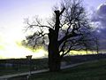
Old tree at a fork in the road in Rhönblick
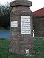
Old signpost at the "Thurmgut" estate (Rhönblick)

.jpg)
Individual evidence
- ^ Population of the municipalities from the Thuringian State Office for Statistics ( help on this ).
- ↑ StBA Area: changes from 01.01. until December 31, 1996
- ↑ http://www.wahlen.thueringen.de/datenbank/wahl1/wahl.asp?wahlart=GW&wjahr=2014&angeboteErg=GEM&wknr=073&gemnr=73111 Thuringian State Office for Statistics: Municipal Council Election 2014 - Rhönblick
Web links

Belrieth | Birx | Breitungen / Werra | Brotterode-Trusetal | Christes | Dillstädt | Einhausen (Thuringia) | Ellingshausen | Erbenhausen | Fambach | Flea Seligenthal | Frankenheim / Rhön | Friedelshausen | Grabfeld | Kaltennordheim | Kühndorf | Leutersdorf (Thuringia) | Mehmels | Meiningen | Neubrunn (Thuringia) | Oberhof | Ober Maßfeld-Grimmenthal | Oberweid | Rhönblick | Rippershausen | Ritschenhausen | Pipe | Pink | Roßdorf (Thuringia) | Schmalkalden | Surge | Schwarza (Thuringian Forest) | Steinbach-Hallenberg | Sülzfeld | Undersize field | Utendorf | Vachdorf | Wasungen | Zella Mehlis