Neubrunn (Thuringia)
| coat of arms | Germany map | |
|---|---|---|
 Help on coat of arms |
Coordinates: 50 ° 30 ' N , 10 ° 28' E |
|
| Basic data | ||
| State : | Thuringia | |
| County : | Schmalkalden-Meiningen | |
| Management Community : | Dolmar salt bridge | |
| Height : | 320 m above sea level NHN | |
| Area : | 9.24 km 2 | |
| Residents: | 506 (Dec. 31, 2019) | |
| Population density : | 55 inhabitants per km 2 | |
| Postal code : | 98617 | |
| Area code : | 036947 | |
| License plate : | SM, MGN | |
| Community key : | 16 0 66 045 | |
| Association administration address: | Zella-Meininger Strasse 6 98547 Schwarza |
|
| Website : | ||
| Mayor : | Martin Schellenberger ( CDU ) | |
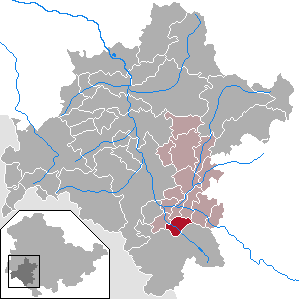
| Location of the community of Neubrunn in the district of Schmalkalden-Meiningen | ||
Neubrunn is a municipality in southwest Thuringia in the district of Schmalkalden-Meiningen , ten kilometers from Meiningen . The municipality is part of the Dolmar Salt Bridge administrative community .
geography
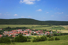
Neubrunn is located in the middle of a hilly landscape at the transition from the Rhön to the Grabfeld on the threshold to Franconia . The Jüchse stream flows through the village .
history
Niunsbrunnen was first mentioned in a document in 857. In 1231 the Neubrunn church was built. The church is in the middle of the village and the defensive character can still be seen. In the west is the high churchyard wall and on the western north side there is a gate and on the north side there is still a gate. The cellars are reminiscent of castle cellars. It is believed that this site used to be a castle district. Over the years, Neubrunn developed into a clustered village .
The place originally belonged to the Zent Themar of the county of Henneberg . In the Henneberg main division in 1274, the two places Jüchsen and Neubrunn came from the Zent Themar to the Henneberg-Schleusingen line and were assigned to the Bailiwick of Henneberg, from which the Amt Maßfeld later formed. In 1680 the place became part of the Duchy of Saxony-Meiningen . Between 1366 and 1496 the lords of Bibra had possessions in the place.
Neubrunn was persecuted by witches from 1602 to 1680: 18 women and two men got into witch trials , 14 were burned and four beheaded. The last victim was Magdalena, Sigmund Henneberger's wife.
In 1639, the plague depopulated Neubrunn. In 1829 Neubrunn came into the possession of the Duchy of Saxony-Meiningen and with this later to the Free State of Thuringia.
The community celebrated its 1150th anniversary in 2007.
Attractions
The listed buildings in the village include the church and two half-timbered houses.
traffic
The place is on the L1131. It connects Meiningen (approx. 10 km northwest) with Römhild (approx. 15 km southeast) and Bad Königshofen im Grabfeld (approx. 30 km south). The closest motorway connection is junction 22 “Meiningen-Süd” of the A 71 (approx. 6 km away). Not far from the village, the Jüchsen viaduct runs over the country road, right next to the south portal of the Eichelberg tunnel .
Individual evidence
- ^ Population of the municipalities from the Thuringian State Office for Statistics ( help on this ).
- ↑ Michael Köhler: Thuringian castles and fortified prehistoric and early historical living spaces. Jenzig-Verlag Köhler, Jena 2001, ISBN 3-910141-43-9 , pp. 187-188.
- ↑ Kai Lehmann : Innocent. Witch hunt south of the Thuringian Forest. Over 500 researched cases from the 16th and 17th centuries. Wehry-Verlag, Untermaßfeld 2012, ISBN 978-3-9813902-8-5 , p. 244 f .; Kai Lehmann: Exhibition "Luther and the Witches". Neubrunn area, Library Museum Schloss Wilhelmsburg Schmalkalden, 2012; Ronald Füssel: The persecution of witches in the Thuringian area (= publications of the working group for historical witchcraft and crime research in Northern Germany. Vol. 2). DOBU-Verlag, Hamburg 2003, ISBN 3-934632-03-3 , pp. 240–244, (at the same time: Marburg, University, dissertation, 2000).
Web links
- Documentary film "mittendrin" about Neubrunn and its residents Jena history workshop, 2006


