
Oberweid
| coat of arms | Germany map | |
|---|---|---|

|
Coordinates: 50 ° 35 ' N , 10 ° 4' E |
|
| Basic data | ||
| State : | Thuringia | |
| County : | Schmalkalden-Meiningen | |
| Management Community : | High Rhön | |
| Height : | 500 m above sea level NHN | |
| Area : | 10.25 km 2 | |
| Residents: | 497 (Dec. 31, 2019) | |
| Population density : | 48 inhabitants per km 2 | |
| Postal code : | 98634 | |
| Area code : | 036946 | |
| License plate : | SM, MGN | |
| Community key : | 16 0 66 052 | |
| Address of the municipal administration: |
Anzenhofer Str. 7 98634 Oberweid |
|
| Website : | ||
| Mayor : | Tino Hencl (Together for Oberweid) | |
| Location of the municipality of Oberweid in the district of Schmalkalden-Meiningen | ||
  |
||

Oberweid is a municipality in the Schmalkalden-Meiningen district in Thuringia . It belongs to the administrative community Hohe Rhön , which has its administrative headquarters in the municipality of Kaltennordheim .
geography
Oberweid is located in the upper valley head of the Weidbach in the Thuringian Rhön . The village is surrounded by the Elbow (Rhön) (814 m), the Weidberg (725 m) and the Staufelsberg (649 m). The place is located in the core zone of the Rhön Biosphere Reserve , one of the last parts of Germany with almost intact natural beauties such as the Rhönwald nature reserve , the Basalt Sea at the Elbow , the former quarry with columnar basalt .
history

Oberweid was first mentioned in 795 in a deed of donation to the Fulda monastery . In the Middle Ages, Oberweid came to the Henneberger as a fief . From 1500 to 1806 the place was in the Franconian Empire . When Count Georg Ernst von Henneberg converted to the Evangelical Lutheran Confession in 1544, Oberweid became Protestant . The place belonged to the office of Kaltennordheim of the county of Henneberg , later to Saxony-Weimar-Eisenach ( Eisenacher Oberland ). From 1609 to 2015 the village had its own parish office.
Oberweid was persecuted by witches from 1629 to 1687 : 23 women and two men were involved in witch trials , 16 people were executed, one woman died under torture, and one was expelled from the country. The first victims in 1629 were Hans Hauck and his wife Apollonia Hauck.
For a short time in the 15th century, a glassworks was operated in the village . In addition, there used to be important art weaving mills and a tapestry factory .
At the First World War, 141 Upper Weider men participated. 35 of them never returned home. In the 1920s, the Federation of Schaffender Landwirte (BsL) under Ernst Putz got involved in Oberweid and had numerous supporters among the population.

Between 1941 and 1945, foreign forced laborers were employed as auxiliary workers in agriculture for numerous farmers in Oberweid . At the Second World War had to attend more than 150 top Weider. Over 60 of them died in the war. In connection with an air raid on Schweinfurt and Nuremberg on March 31, 1944, a Lancaster of the Royal Air Force crashed below the summit of the Ellenbogen near Oberweid ( crash site ). Five crew members (Sergeant RJA Boon, Sergeant JA Hildreth, Flying Officer EC Espley, Sergeant HR Lawrence and Sergeant LG Washer) were killed and were buried without honor in the cemetery in Oberweid. After the end of the war, she was transferred to a British war dead cemetery in Berlin . The pilot Flight Lieutenant PE Underwood and the radio operator Sergeant AE Evans survived the crash and were taken prisoner of war . After the end of the war, they were able to return to their homeland.
On the afternoon of April 1, 1945, it was Easter Sunday, US troops advanced from Unterweid into Oberweid without a fight. Several citizens had already hoisted a white flag on the church tower that morning. The Second World War ended in this place. In the summer of 1945 the western allies withdrew and Oberweid was occupied by Soviet troops . From 1961 to 1990 the centuries-old border line, only a few hundred meters away from the municipality, became the inner-German border . With the establishment of a border crossing on December 3, 1989, the road to Simmershausen in Hesse became usable again.
politics
Municipal council
The local council from Oberweid consists of 8 councilors.
- Schützenverein Oberweid 1990 eV: 2 seats
- Free Community of Voters (FWG) Oberweid: 3 seats
- Football club SV Germania Oberweid 1929 eV: 3 seats
(As of: local elections on May 25, 2014)
mayor
The honorary mayor Tino Hencl (Together for Oberweid) was elected on June 5, 2016.
Culture
tourism
Noah's sails

The 21 m high viewing platform on the summit of the 813 m high Ellenbogen (Rhön) offers a wonderful view of the Brocken in the Harz Mountains (low mountain range) and the Steigerwald . After climbing the stairs, the adventure slide can be used to descend.
Elbow (rhön)
The elbow is an 813 m above sea level. NHN high mountain of the Rhön in the Thuringian district of Schmalkalden-Meiningen ; lower parts of its flanks lie in Bavaria and Hesse . About 1.5 km to the south is the Schnitzersberg ( 815.5 m ), the highest point in the Thuringian Rhön. The mountain is of volcanic origin.
High Rhön Discovery Trail
The 18 km long hiking trail itself is the heart of a newly created network of excursion destinations in the region. The hiking route offers 21 starting points and experiences. Round trips are possible in connection with the local hiking trails or Rhön club trails.
At the various stations, children can, for example, climb like ants, feel like a stork in a nest or crawl around like a spider. The whole family learns interesting facts about the region along the way - from water to forest, the border history or the ghosts and myths of the Rhön. Not only can mental fitness be tested for this.
The thematic stages:
- “Rhönwasser” - on this section of the trail that begins near Unterweid - an enchanted miller's daughter is waiting to be freed. Hear the wind, solve the puzzles, test the power of the water and test your knowledge and attentive eye on the cascades!
- “Rhönwald” discovery trail - Mandra, the pregnant woman fire salamander, is looking for a spawning place for her larvae. On her search she meets various forest animals. Squirrels, ants, black storks and other Rhönwald inhabitants invite you to live with you. What will she choose?
- "Rhöngeister" - Truth or Poetry? Fantasy figure or natural phenomenon? This section of the path is a bit mysterious. At the Hexenstein, Rosetta tries to outsmart you, at the pond you have to be faster than the slit eye, then you fly almost like the red kite over the landscape. And finally you will meet the Rhön weather gods.
- "History of the Rhön" - The Rhön as a borderland between the federal states of Hesse, Bavaria and Thuringia, but also the time as the border between the Eastern and Western blocs are discussed on this section of the route. Hear exciting borderline stories and learn interesting facts about special residents of the Green Belt in the bird song quiz.
Bird trail
A circular path on the edge of the village offers information on the local avifauna with several information boards .
Hiking trails
The Hochrhöner premium hiking trail runs above the village .
The Rhön-Rennsteig hiking trail that comes from the Wasserkuppe and continues to Oberhof leads over the Elbow (Rhön) .
Sports
- Schützenverein Oberweid 1990 e. V.
- The association was founded in 1990 and has around 40 members. The disciplines air rifle, air pistol, sport rifle and sport pistol are trained. Members regularly take part in competitions at district, state and federal level. Several successes as district and regional champions have already been achieved. The club has had at least one team in the district league since the league was formed in 1996.
- Football club SV Germania Oberweid 1929 e. V.
- The local football club was founded in 1929 and plays in the 1st district class. Renamed during the GDR era , it was called BSG Traktor Oberweid until 1990. The venue for his games is the Rhönsportanlage Staufelsberg. The association is the organizer of the annual costume fair.
Sports facilities
Rhönsportanlage Staufelsberg
- Soccer field
- Outdoor table tennis
- Beach volleyball
societies
- Oberweid volunteer fire brigade
- The volunteer fire brigade has existed to protect the residents since the end of the 18th century .
- Church choir harmony
- Founded in 1900, the church choir conducts spring singing annually with guest choirs. In the run-up to Christmas there is an Advent singing in the village church of St. Michael.
- Oberweider Carnevals Club (OCC)
- The Carnevalsverein, founded in 1955, is firmly rooted in the community structure. Festive meetings and a pageant are organized annually. Members take part in guest meetings and competitions nationwide.
- Rhönklub branch association Oberweid
Regular events
The traditional highlights of the place include the carnival events, the Backhaus Festival in June, the sports and rifle festival in summer and the fair with the traditional tapping of cocks or guckles in October.
Culinary specialties
A typical specialty is the onion cake, called Zwübelsploatz in Oberweid. This used to be baked in the bakery.
dialect
When it was founded, Oberweid was in the heart of the Franconian Empire and has since been part of the East Franconian language area , which in turn belongs to the Upper German language area. Here is Hennebergisch , a subspecies of Mainfränkisches spoken. “Platt” is spoken less and less in everyday life today.
Attractions
Buildings
In Oberweid there are several well-preserved half-timbered houses that are under protection.
The nave of the Protestant Church of St. Michael dates from 1609. The choir tower (1576) is older and was raised with slated timber. In 1632 the church was enlarged. Except for the two-storey galleries, the equipment is simple. Pastor Johann Krieg was buried in the church in 1652, who is said to have been martyred to death by a " witch ". In 1676/77 and 1687 Regina, the widow of Pastor Peter Kriegs was accused in a witch trial, but acquitted. Noteworthy is the font from 1551, which gives an example of the early modern period, which is still entirely in the spirit of the Gothic. With a round basin over an octagonal base, it is decorated with rosettes and the Henneberg coat of arms. The fortified church was restored (interior restoration 1980–1981; exterior restoration 1995–1998) and is worth seeing.

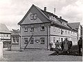
Half-timbered house by Georg Fey in Oberweid around 1920, grocery store and gas station
"Zur Post" inn in Oberweid around 1920

August Flöhl's farm in Oberweid around 1920


Monuments
- There are two atonement crosses made of sandstone on the cemetery wall . One of the crosses is embedded flush in the cemetery wall, with the broken right arm being inserted into the wall a little below the break.
- On the eastern outskirts in the direction of Kaltenwestheim there is a memorial stone for the messenger Johannes Herpich, who was frozen to death there in December 1798 and buried in Frankenheim in March 1799.
- A memorial plaque has been placed in the Church of St. Michael for the fallen of the First World War .
- A memorial stone in the center of the village commemorates those who died in the First and Second World Wars .
- On the Oberweid – Simmershausen hiking trail , a memorial plaque was created to commemorate the Anzenhof and Ziegelhütte settlements . The village of Anzenhof, which was founded in the 16th century at the latest, was evacuated in 1975 and razed to the ground. The small settlement of Ziegelhütte, consisting of three houses and ancillary buildings, was cleared and demolished as early as 1970. Both settlements were only a few hundred meters away from the German-German border, within the 500 m restricted area belonging to the GDR border systems , which should not be inhabited. The Rhön Club donated a plaque in 1999.
- On the road to Simmershausen at the municipal boundary , a memorial designed by the Oberweider visual artist Waldo Dörsch commemorates the opening of the border on December 3, 1989.
economy
Typical craft businesses such as carpentry, plumbing and heating construction, tiling, locksmithing and electrical trades determine the economic structure of Oberweid. Most of the agricultural land is managed by Landschaftspflege-Agrarhöfe GmbH & Co. KG, based in Kaltensundheim.
traffic
From Oberweid you can take the Meininger Busbetriebs GmbH line 411 on weekdays to reach the district town of Meiningen , 32 km to the east , which is also a railway junction.
The following train stations are even closer:
- 27 km southwest: Gersfeld (Rhön) on the Fulda – Gersfeld railway line
- 28 km east: Wasungen and Walldorf on the Eisenach – Meiningen railway line
- 31 km to the west: Hünfeld on the Bebra – Fulda railway line
Personalities
- Waldo Dörsch (1928–2012), sculptor
Individual evidence
- ^ Population of the municipalities from the Thuringian State Office for Statistics ( help on this ).
- ↑ Oberweid. Rhön Lexicon, accessed on July 18, 2012 .
- ^ Evangelical Church of St. Michael in Oberweid. Rhön Lexicon, accessed on July 18, 2012 .
-
↑ Kai Lehmann : Innocent. Witch hunt south of the Thuringian Forest. Over 500 researched cases from the 16th and 17th centuries. Wehry-Verlag, Untermaßfeld 2012, ISBN 978-3-9813902-8-5 , p. 280 f .;
Kai Lehmann: Exhibition "Luther and the Witches". Oberweid area, Library Museum Schloss Wilhelmsburg Schmalkalden, 2012;
Ronald Füssel: The persecution of witches in the Thuringian area (= publications of the working group for historical witchcraft and crime research in Northern Germany. Vol. 2). DOBU-Verlag, Hamburg 2003, ISBN 3-934632-03-3 , p. 239 f. (At the same time: Marburg, University, dissertation, 2000). - ↑ Mayoral elections 2016 in Thuringia. The regional returning officer, accessed on June 21, 2016 .
- ↑ a b Map services of the Federal Agency for Nature Conservation ( information )
- ↑ Gückelschlag (folklore tradition). Rhön Lexicon, accessed October 1, 2012 .
- ↑ University of Jena - Dialect Research ( Memento of the original from March 9, 2018 in the Internet Archive ) Info: The archive link was inserted automatically and has not yet been checked. Please check the original and archive link according to the instructions and then remove this notice.
- ↑ Atonement Crosses and Murder Stones. Sven Gerth, accessed July 14, 2010 .
- ↑ Atonement Crosses and Murder Stones. Sven Gerth, accessed July 14, 2010 .
- ↑ Here was the Anzenhof . In: Rhönwacht . No. 4 , 1999, ISSN 0936-1723 , p. 160 .
Web links
- Tourist information - Oberweid
- Tourist information - Noah's sails viewing platform
- - Tourist information - High Rhön discovery trail
- Page about Oberweid
- Oberweid on vgem-hoherhoen.de, on May 1, 2015

Belrieth | Birx | Breitungen / Werra | Brotterode-Trusetal | Christes | Dillstädt | Einhausen (Thuringia) | Ellingshausen | Erbenhausen | Fambach | Flea Seligenthal | Frankenheim / Rhön | Friedelshausen | Grabfeld | Kaltennordheim | Kühndorf | Leutersdorf (Thuringia) | Mehmels | Meiningen | Neubrunn (Thuringia) | Oberhof | Ober Maßfeld-Grimmenthal | Oberweid | Rhönblick | Rippershausen | Ritschenhausen | Pipe | Pink | Roßdorf (Thuringia) | Schmalkalden | Surge | Schwarza (Thuringian Forest) | Steinbach-Hallenberg | Sülzfeld | Undersize field | Utendorf | Vachdorf | Wasungen | Zella Mehlis