Elbow (rhön)
| Elbow
Schnitzersberg
|
||
|---|---|---|
|
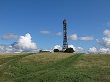
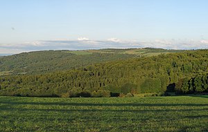
View from the book screen to the east to the elbow |
||
| height | 813 m above sea level NHN | |
| location | Thuringia , Bavaria , Hesse ( Germany ) | |
| Mountains | Rhön | |
| Coordinates | 50 ° 34 '22 " N , 10 ° 4' 54" E | |
|
|
||
| rock | basalt | |
| Development | State road 1123 | |
| particularities | - Noahs Segel observation tower - The elbow is one of the highest elevations in the Thuringian part of the Rhön with the Schnitzersberg ( 815.5 m ) and the Hinterer Rhön ( 813.7 m ) . |
|

The elbow is an 813 m above sea level. NHN high mountain of the Rhön in the Thuringian district of Schmalkalden-Meiningen ; lower parts of its flanks lie in Bavaria and Hesse . About 1.5 km to the south is the Schnitzersberg ( 815.5 m ), the highest point in the Thuringian Rhön. The mountain is of volcanic origin.
The Eisenach house stands on the elbow , not far from it is the Thuringian Rhön House and a transmitter mast on the Schnitzersberg .
geography
location
The elbow with its summit Schnitzersberg rises in the district of Schmalkalden-Meiningen (Thuringia) between the villages of Oberweid in the north-north-west, Erbenhausen - Reichenhausen in the north-east and Frankenheim in the south-south-west; the last named of these three Thuringian villages is a few meters below the mountain plateau near the border triangle Bavaria – Hessen – Thuringia. The southeast flank of the Schnitzersberg lies in the district of Rhön-Grabfeld (Bavaria) and its western flank in the district of Fulda (Hesse). Both Ellenbogen and Schnitzersberg are located with a Thuringian peak in the Rhön Biosphere Reserve . Lower flank parts are in the area of the respective federal states in the Hessian Rhön and Bavarian Rhön nature parks .
The Weid rises to the west of the elbow or north-northwest of the summit of the Schnitzersberg , a south-eastern tributary of the Ulster, which passes the mountain west of Hesse from south to north . The Streu , a northern tributary of the Franconian Saale, rises in Bavaria to the east of the Elbow or northeast of the Schnitzersberg .
Natural allocation
Ellenbogen and Schnitzersberg belong to the natural spatial main unit group Osthessisches Bergland (No. 35), the main unit Hohe Rhön (354) and the subunit Central Rhön (354.1) to the natural area Lange Rhön (354.11). To the east, the landscape falls into the natural area of the Ostabfall der Langen Rhön (354.12). In this direction it leads through the aforementioned natural area into the natural area Auersberger Kuppenrhön (353.24), into which it drops to the north and northwest and which in the main unit Vorder- und Kuppenrhön (353) belongs to the subunit Kuppenrhön (353.2).
Mountain heights and crests
At the elbow and Schnitzersberg or in the area of the Drei Spitzen there are the highest points or hills above the 800 m height line - sorted by height in meters (m) above sea level (NHN) and distances to the summit of the Schnitzersberg in kilometers (km ):
- Schnitzersberg ( ⊙ ; 815.5 m ; highest mountain in the Thuringian part of the Rhön; one of the three peaks )
- Hintere Rhön ( ⊙ ; 813.7 m , 0.7 km northwest; one of the three peaks )
- Elbow ( ⊙ ; 813 m , 1.6 km north)
- nameless hill ( ⊙ ; 812.5 m , 0.3 km south; one of the three peaks )
- Schafküppel ( ⊙ ; 806.8 m , 2.1 km north-northeast)
However, in most maps, the rounded height from the elbow is given as 814 m and that of the Schnitzersberg as 816 m . The over 800 m high areas of the mountain plateau extend on the western flank from the Schnitzersberg to Hesse and the areas below it in the southeast, with the siblings Rhönkopf and Salkenberg ( 773 m ) to Bavaria .
Protected areas
Parts of the nature reserve (NSG) Rhönkopf-Streufelsberg ( CDDA no. 165168; designated in 1967; 5.1411 km² in size) extend to the east and south flanks of the Ellenbogen and Schnitzersberg and parts of the NSG Rhönwald (CDDA no . 165169; 1967; 1.3247 km²). Parts of the Thuringian Rhön landscape protection area (CDDA no. 20897; 1989; 631.89 km²) lie on the entire elevation . Parts of the fauna-flora-habitat area Hohe Rhön (FFH no. 5426-320; 16.2 km²) and the Thuringian Rhön bird sanctuary (VSG no. 5326-401; 199.49 km²) are located in large parts .
Development
Buildings
Near the summit of the Elbow is the Eisenacher Haus , which was built in 1928 by the Rhönklub zweigverein Eisenach as a hiking home. It was first expropriated during the Cold War and then used as a listening post for the GDR due to its proximity to the border . There is currently a hotel in the house. About 1 km southwest of the Eisenacher Haus is the Thuringian Rhönhaus ( mountain restaurant and boarding house, including an animal enclosure ), hidden in the forest . There is a transmitter mast on the Schnitzersberg and the Weidenhof farmers around 700 m west of it . On June 3, 2016, work on the construction of the Noah's Sails observation tower with slide and exhibition building began on the summit of the Elbow . After the work was completed, the opening took place on August 6, 2017. Since then, it can be climbed during opening times for a small fee.
Transport, hiking and winter sports
The section Frankenheim - Reichenhausen of Landesstraße 1123 runs over the ridge. The Rhön-Rennsteig hiking trail from the Wasserkuppe leads over Ellenbogen and Schnitzersberg and continues to Oberhof . The Rhön-Höhen-Weg , the Milseburgweg and other local hiking trails and circular hiking trails meet at the Eisenacher Haus .
The top of the elbow is a good vantage point in both west and north directions. While Wasserkuppe (13 km), Milseburg (13 km) and Großer Inselsberg (41 km) can often be seen, the clear view only extends to Kahler Asten (131 km) or Brocken (141 km) on a few days a year .
For winter sports there is a ski and toboggan park with a lift on the Elbow.
panorama
See also
Individual evidence
- ↑ a b c d e f Map services of the Federal Agency for Nature Conservation ( information )
- ↑ View as far as the Brocken: The “Noahs Segel” observation tower in the Rhön opens the Fuldaer Zeitung on August 10, 2017, accessed on January 16, 2020
- ↑ Opening times and prices at noahs-segel.de , accessed on December 22, 2017
literature
- Rhönklub e. V. (ed.), Through the Rhön. 2001, Verlag Parzeller Fulda, ISBN 3-7900-0327-1 , p. 102 ff.
- Rhönklub e. V. (ed.), Schneider's Rhönführer. 2005, Verlag Parzeller Fulda, ISBN 3-7900-0365-4 , p. 273.
Web links
- View from the elbow before erecting the observation tower (labeling of visual targets can be activated), on panorama-photo.net


