
Milseburg
| Milseburg | ||
|---|---|---|
 Milseburg from the west |
||
| height | 835.2 m above sea level NHN | |
| location | with small people ; District of Fulda , Hessen ( Germany ) | |
| Mountains | Rhön (Kuppenrhön) | |
| Coordinates | 50 ° 32 '41 " N , 9 ° 53' 52" E | |
|
||
| Type | Spring tip | |
| rock | Phonolite , basalt | |
| Age of the rock | Originated in the tertiary | |
| particularities | - Oppidum Milseburg - Milseburg Castle (near) - Gangolf chapel - Milseburg hut - Justus Schneider monument |
|

The Milseburg is 835.2 m above sea level. NHN high mountain in the Rhön . It is located near Danzwiesen in the municipality of Hofbieber in the Hessian district of Fulda ( Germany ).
On the mountain are the remains of the Milseburg oppidum , the Gangolf chapel , the Milseburg hut and the Justus Schneider monument. The remains of Milseburg Castle lie on the north-west spur of the Liedenküppel .
geography
location
The Milseburg is the highest point of the Kuppenrhön . It rises in the Hessian Rhön Nature Park and the Rhön Biosphere Reserve between the districts of Danzwiesen in the east, which belongs to the municipality of Hofbieber , to which it belongs, and Kleinsassen in the west-northwest and the Hilders district of Oberbernhards in the north-northeast. About 16 km (as the crow flies ) to the west lies Fulda , by far the largest city in the region.
Neighboring mountains to the Milseburg are the Oberbernhardser Höhe ( 660.9 m ) located about 1.5 km to the north with the source of the Scheppenbach tributary Dörmbach , the 1.2 km southeast of the Bubenbader Stein ( 758.8 m ), the 2.9 km south of the Teufelstein ( 729.4 m ) with the headwaters of the Bieber and the 1.9 km southwest of Stellberg ( 727.4 m ). The north-western side knoll of the Milseburg is the Liedenküppel ( 647.8 m ) 0.6 km away , from which the Mambach tributary Hummelborngraben rises.
Natural allocation
The Milseburg belongs to the natural spatial main unit group Osthessisches Bergland (No. 35), in the main unit Vorder- und Kuppenrhön (353) and in the subunit Kuppenrhön (353.2) to the natural area Milseburger Kuppenrhön (353.21). The landscape leads to the west to the subunit Western Rhön foreland (353.1) and to the southeast to the Wasserkuppenrhön natural area (354.10), which is part of the main unit Hohen Rhön (354) to the subunit Central Rhön ( Hochrhön ; 354.1).
geology
The striking Milseburg owes its emergence to the tertiary volcanism in the area of today's Rhön. At that time, alkaline magma penetrated from greater depths in the direction of the earth's surface, which was well above today's surface. However, the ascent got stuck relatively close under the surface of the earth at that time in layers of red sandstone and the magma cooled there and finally solidified into a phonolite body. By erosion was the overlying and later the surrounding, softer in the following year, millions Trias eroded rock as deep-reaching that the Phonolithkörper was dissected and now m towers above the surrounding landscape Milseburg by about 130th
The extreme climate of the cold periods of the Pleistocene led the Phonolithkörpers to an extensive physical weathering, so that on its slopes vast boulders formed.
Protected areas
The Milseburg nature reserve is located on the Milseburg ( CDDA no. 82165; designated 2001; 46.14 hectares in size). On December 22, 2005 Hofbieber acquired a 26 hectare part of the protected area from Johannes von und zu Guttenberg ( Bad Neustadt / Saale); the purchase price of € 200,000 was raised by the state of Hesse and sponsors (including the Rhön Club ). This means that free access is still guaranteed.
On the mountain there are parts of the Hessische Rhön landscape protection area (CDDA no. 378477; 1967; 410.1096 km² ), the fauna-flora-habitat area Vorderrhön (FFH no. 5325-305; 36.904 km²) and the Hessische bird protection area Rhön (VSG no. 5425-401; 360.8013 km²).

history
General
Remains of the Celtic settlement Oppidum Milseburg lie on the north-western slope of the mountain . On the footpath there to the mountain summit, you pass the remains of the ring wall and several annex walls . In 2003/2004 an extensive archaeological exploration project was carried out on the approximately 2100 year old Celtic up to twelve meter wide “city wall” at the southeastern mountain foot. At this point, a reconstruction as true to the original as possible, which is explained on display boards.
The mountain was first mentioned in a document by Emperor Otto II on July 25, 980. The Milsiburg was mentioned as a border town between the area of the Fulda monastery and the area belonging to Hünfeld . The designation as a castle hardly allows any other conclusion than that a castle already existed on the mountain at that time. However, such a complex, Milseburg Castle , was first mentioned in a document in 1119 . This castle was located on the Liedenküppel to the northwest of the Milseburg , as sparse remains prove. Their facility was very small at 21 × 24 m. It is believed that it was abandoned in the 13th century at the latest and then gradually fell into disrepair.
Tell about the formation of the mountain
The mountain owes its name to a legend about the "giant Mils", who is said to have been up to mischief here in association with the devil. Saint Gangolf is said to have finally defeated him, whereupon the "giant Mils" killed himself. The devil finally covered the body with stones - this is today's Milseburg.
Crucifixion group and buildings
On the Milseburg there is a crucifixion group from 1756, below it a small pilgrimage chapel in honor of Saint Gangolf - the Gangolf chapel . A stone pulpit on the area next to the chapel allows a sermon in the open air. Directly below the chapel is a refuge built by the Rhön Club from 1883 to 1884 - the Milseburghütte . It has belonged to the Hofbieber community since 2018.

Crucifixion group on the summit

Gangolf Chapel on the Milseburg

Interior of the Gangolf Chapel
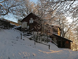
Milseburghütte, in the background the Gangolf chapel


.jpg)
Traffic, hiking and viewing opportunities
The state road 3379 runs north of the Milseburg between Kleinsassen and Oberbernhards. District road 20 branches off from here between the two villages and leads east of the mountain as a spur road to Danzwiesen. Almost 2 km southeast of the Budenbader Stein between Mittelberg ( Poppenhausen ) and Dietges (Hilders) is the federal highway 458 .
Milseburg can be reached from Fulda and Hilders by bike on the Milseburgradweg , which runs on the route of the former Götzenhof – Wüstensachsen (Rhönbahn) line. The last 100 meters to the summit are steep. The Milseburg tunnel on this route , which is north of the neighboring Oberbernhardser Höhe , can be driven through by bike in the warm season. The Tunnelrun takes place every year on the cycle path and through the tunnel , a fun run event organized by the Petersberg running club, supported by the communities of Petersberg , Hofbieber and Hilders.
The European long-distance hiking trail E6 leads over the northern highlands of the Milseburg . The mountain can also be reached via the Hochrhöner ( Bad Kissingen - Bad Salzungen ) and Milseburgweg (Fulda - Meiningen ) hiking trails that cross there . The Rhön Club under Justus Schneider contributed a large part to its development ; the Justus Schneider monument near the Milseburghütte commemorates the club's initiator.
The Milseburg is one of the most famous mountains beyond the Rhön and is therefore a popular destination. Its peaks, which are bare in some places, easily accessible and yet exposed, offer good prospects. The view falls over the Kuppenrhön and the Wasserkuppe .
gallery

View from Milseburg to the Wasserkuppe
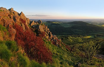
Rock bar in the summit area with a view to the west, Stellberg on the left

Rocks on the north side
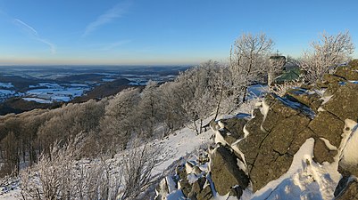
Winter view along the west side of the summit to the north

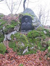
Monument to the Fulda bishop Georg von Kopp at the foot of the Milseburg
Justus Schneider monument near the Milseburghütte
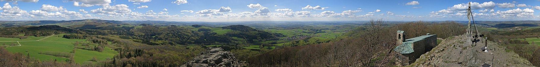
Panorama from the summit of the Milseburg


See also
literature
in order of appearance
- Willy Kiefer: The Milseburg. 2nd edition, Verlag Parzeller, Fulda 1999, ISBN 3-7900-0222-4 .
- Joachim Jenrich: The Milseburg - pearl of the Rhön. Parzeller publishing house, Fulda 2005, ISBN 3-7900-0371-9 .
- Ulrike Söder, Frank Verse: The Milseburg - news from an old friend . In: Fuldaer Geschichtsblätter , ISSN 0016-2612 , Vol. 91/92 (2015/2016), pp. 7-18.
- Frank Verse: New archaeological research on the Milseburg , Buchenblätter 207/8, supplement of the Fuldaer Zeitung, accessed on May 9, 2017
Web links
- Literature about Milseburg in the Hessian Bibliography
- Marco Klüber: Milseburg photo gallery , on flickr.com
- Milseburgradweg , on milseburgradweg.de
- 360-degree panorama from the summit , on panorama-photo.net
- Milseburghütte , on milseburghuette.com
- Aerial video Milseburg , from Hessischer Rundfunk
Individual evidence
- ↑ a b c Map services of the Federal Agency for Nature Conservation ( information )
- ↑ Werner Röll: Geographical land survey: The natural spatial units on sheet 126 Fulda. Federal Institute for Regional Studies, Bad Godesberg 1969. → Online map (PDF; 4.2 MB)
- ↑ Michael Mott : Celtic Milseburg finds: glass beads and ceramics / archaeological excavations at the Rhön cultural monument are making good progress. in: Fuldaer Zeitung, August 27, 2003, p. 11.