Petersberg (Hesse)
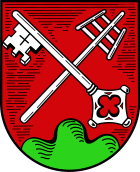
| coat of arms | Germany map | |
|---|---|---|

|
Coordinates: 50 ° 33 ' N , 9 ° 43' E |
|
| Basic data | ||
| State : | Hesse | |
| Administrative region : | kassel | |
| County : | Fulda | |
| Height : | 360 m above sea level NHN | |
| Area : | 35.51 km 2 | |
| Residents: | 16,052 (Dec. 31, 2019) | |
| Population density : | 452 inhabitants per km 2 | |
| Postal code : | 36100 | |
| Area code : | 0661 | |
| License plate : | FD | |
| Community key : | 06 6 31 020 | |
| Community structure: | 6 districts | |
| Address of the municipal administration: |
Rathausplatz 1 36100 Petersberg |
|
| Website : | ||
| Mayor : | Carsten Froß ( CDU ) | |
| Location of the community Petersberg in the district of Fulda | ||
Petersberg is a suburb of Fulda in the Fulda district in East Hesse , Germany .
geography
location
The community is located directly on the north-eastern city limits of Fulda in the western foothills of the Rhön . The Haune flows through the municipality .
Neighboring communities
Petersberg borders in the north on the city of Hünfeld , in the east on the municipality Hofbieber , in the southeast on the municipality Dipperz , in the south on the municipality Künzell and in the west on the city of Fulda (all in the district of Fulda).
Community structure
In addition to Petersberg, the community consists of the districts Haunedorf , Marbach , Margretenhaun , Steinau (with the hamlet of Götzenhof) and Steinhaus .
history
The history of the place began with the foundation of a Benedictine monastery on the Ugesberg (Eulenberg), which was consecrated on September 28, 836 by the Fulda abbot Rabanus Maurus . On this day, St. Lioba was reburied in St. Peter's Basilica . The monastery developed into a provost house in the 12th century , which was closed in 1802.
From 1130 the Ugesberg was called Petersberg. A settlement emerged at the foot of the mountain, which was first mentioned in 1153 as the Bru-bus (brewery). The name of the place Petersberg became common by the Hessian electoral ordinance from 1837, when the place and the provost district were united.
Today there is again a Cella St. Lioba , which was founded by the Benedictine nuns of St. Lioba . They also took care of St. Peter's Church of the Holy Sepulcher.
Incorporations
On December 31, 1971, the previously independent communities of Haunedorf, Marbach, Margretenhaun, Steinau and Steinhaus were merged into the new community of Petersberg as part of the municipal reform.
politics
Community representation
The local elections on March 6, 2016 produced the following results, compared to previous local elections:
| Parties and constituencies |
% 2016 |
Seats 2016 |
% 2011 |
Seats 2011 |
% 2006 |
Seats 2006 |
% 2001 |
Seats 2001 |
||
|---|---|---|---|---|---|---|---|---|---|---|
| CDU | Christian Democratic Union of Germany | 54.0 | 20th | 60.5 | 22nd | 63.1 | 23 | 65.3 | 24 | |
| SPD | Social Democratic Party of Germany | 17.8 | 6th | 23.1 | 9 | 24.0 | 9 | 24.7 | 9 | |
| CWE | Christian voter unit eV | 16.6 | 6th | 13.0 | 5 | 10.4 | 4th | 10.0 | 4th | |
| The left | Die Linke.open list | 7.1 | 3 | 3.4 | 1 | - | - | - | - | |
| FDP | Free Democratic Party | 4.4 | 2 | - | - | 2.5 | 1 | - | - | |
| total | 100.0 | 37 | 100.0 | 37 | 100.0 | 37 | 100.0 | 37 | ||
| Voter turnout in% | 54.9 | 52.5 | 46.4 | 52.5 | ||||||
mayor
After the Hessian municipal constitution is the Mayor Chairman of the Municipal Board , the six volunteers in the municipality Petersberg next to the Mayor Councilor belong. As the first directly elected mayor in Petersberg, Karl-Josef Schwiddessen (CDU) has been in office since 1994 in his fourth term of office, which lasted until 2018. His successor Carsten Froß (CDU) took office in March 2018.
Community partnerships
- Billère ( Pyrénées-Atlantiques , France )
- Sabiñánigo ( Spain )
- Breitungen / Werra (in Thuringia)
Culture and sights
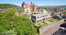
One of the sights is the Church of St. Peter (Liobakirche) with the crypt in which the bones of St. Lioba are locked. Another attraction is the former nun's garden with a flower wall, which was created in the 14th century. In the summer of 2013, the nun's garden was converted into a park as part of the “ 72-hour campaign ” and has been accessible since then. Today the nunnery is no longer in the same place. Since July 2006, a small nunnery of the Benedictine Sisters of St. Lioba, the Cella St. Lioba , has been located on the Peterberg next to the Church of St. Peter .
Museums
- Active museum - rural customs
Buildings
- Bergkirche St. Peter , Holy Sepulcher Church of St. Lioba , which was consecrated in 836
- Baroque chapel of St. Boniface (in the cemetery) from 1698/99 with a baroque wooden altar and some epitaphs from the 16th to 18th centuries
- Rabanus Maurus Church from 1957 with a free-standing bell tower
- Haunetalsperre
- Petersberg watch tower on the Rauschenberg, which was later converted into an observation tower
Bike trails
The Milseburgradweg runs through the districts of Almendorf and Melzdorf . As part of the Hessian long-distance cycle route R3 and the Hesse rail cycle route, it runs on the former Rhön railway route Biebertalbahn / Rhönbahn over a length of 27 kilometers from Petersberg- Götzenhof to Hilders through the Hessian Rhön .
traffic
Petersberg is in the immediate vicinity of the Fulda-Mitte motorway junction. Federal roads 27 and 458 also run through the municipality . The closest train station is in Fulda .
Personalities
- Jan-Philip Glania (* 1988) - swimmer
- Johannes Hack (1875–1950) - teacher and local history researcher
- Markus Meysner (* 1966) - politician and member of the Hessian state parliament
- Apollo of Vilbel (around 1480-1536) - Benedictine abbot in the monastery Limburg , provost at the Petersberg , chronicler, lived temporarily and died here, get grave plate in the St. Peter's Church
literature
- Werner Kathrein and Johannes Burkardt: Petersberg (Fulda) . In: Friedhelm Jürgensmeier et al.: The Benedictine monasteries and nunneries in Hessen (Germania Benedictina 7 Hessen), Eos, St. Ottilien 2004, pp. 900–909. ISBN 3-8306-7199-7 .
- Michael Mott : Baroque chapel without “host” / The cemetery chapel of St. Bonifatius on Petersberg is to be renovated and then opened to visitors / Riot at church facilities. In: Fulda newspaper. March 25, 1993, p. 12 (series: DENK-mal!).
Individual evidence
- ↑ Hessian State Statistical Office: Population status on December 31, 2019 (districts and urban districts as well as municipalities, population figures based on the 2011 census) ( help ).
- ↑ Congregation structure on the Geimde page (accessed in Nov. 2012)
- ^ Federal Statistical Office (ed.): Historical municipality directory for the Federal Republic of Germany. Name, border and key number changes in municipalities, counties and administrative districts from May 27, 1970 to December 31, 1982 . W. Kohlhammer GmbH, Stuttgart / Mainz 1983, ISBN 3-17-003263-1 , p. 393 .
- ^ Result of the municipal election on March 6, 2016. Hessian State Statistical Office, accessed in April 2016 .
- ^ Hessian State Statistical Office: Result of the municipal elections on March 27, 2011
- ^ Hessian State Statistical Office: Result of the municipal elections on March 26, 2006
- ^ Hessian State Statistical Office: Direct elections in Petersberg
- ↑ Town twinning on the municipal website (accessed in Nov. 2012)
Web links
- "Petersberg, District of Fulda". Historical local dictionary for Hessen. In: Landesgeschichtliches Informationssystem Hessen (LAGIS).
- Link catalog on Petersberg at curlie.org (formerly DMOZ )


