
Gersfeld (Rhoen)
| coat of arms | Germany map | |
|---|---|---|

|
Coordinates: 50 ° 27 ' N , 9 ° 55' E |
|
| Basic data | ||
| State : | Hesse | |
| Administrative region : | kassel | |
| County : | Fulda | |
| Area : | 89.37 km 2 | |
| Residents: | 5460 (Dec. 31, 2019) | |
| Population density : | 61 inhabitants per km 2 | |
| Postal code : | 36129 | |
| Primaries : | 06654, 06656 | |
| License plate : | FD | |
| Community key : | 06 6 31 010 | |
| LOCODE : | DE GFD | |
| City structure: | 13 districts | |
City administration address : |
Marktplatz 19 36129 Gersfeld (Rhön) |
|
| Website : | ||
| Mayor : | Steffen Korell ( CDU ) | |
| Location of the city of Gersfeld (Rhön) in the Fulda district | ||
 _in_FD.svg) |
||


The town of Gersfeld (Rhön) is located in the Fulda district in East Hesse , embedded in the Rhön . As a recognized climatic health resort and Kneipp spa , Gersfeld is the starting point for hikes through the Rhön biosphere reserve and for winter sports. The Haderswald in the south is largely closed, as the northern part of the Wildflecken military training area is located here.
geography
Geographical location
Gersfeld is surrounded by mountains in a semicircle. Since these must be assigned to the Hohe Rhön as a natural spatial unit, the municipality is located exactly on the border of two natural spatial units. The health resort is located in the south-west facing Fulda valley in the middle of the UNESCO Rhön Biosphere Reserve .
As a result of the municipal reform in 1971/72, the places Altenfeld, Dalherda, Gichenbach, Hettenhausen, Maiersbach, Mosbach, Obernhausen, Rengersfeld, Rodenbach, Sparbrod, Rommers, Sandberg and Schachen were incorporated into Gersfeld. The majority of the districts are on the edge of the valley floors or at the confluences of side valleys.
With more than a third (34.7%), the agriculturally used area with a high proportion of grassland occupies large areas at medium altitude in the district. The forest area also has a large proportion of the area (37.9% of the municipal area), which, however, is limited to the slopes and high areas that are relatively remote from the town.
Neighboring communities
Gersfeld borders in the north on the municipality of Poppenhausen (Wasserkuppe) , in the northeast on the municipality Ehrenberg (both in the district of Fulda), in the east on the Markt Oberelsbach and the town of Bischofsheim (in the district of Rhön-Grabfeld in Bavaria ), in the south on the Markt Wildflecken (in the Bavarian district of Bad Kissingen ) and in the west to the municipality of Ebersburg (district of Fulda).
City structure
In addition to the eponymous Gersfeld, the city includes twelve districts: Altenfeld , Dalherda , Gichenbach , Hettenhausen , Maiersbach , Mosbach , Obernhausen , Rengersfeld , Rodenbach , Rommers , Sandberg and Schachen . The Sampach desert is also located in the urban area .
history

Gersfeld was first mentioned in a document as Geraldisfeld in 944. The place owes its origin to the Lords of Schneeberg .
etymology
The name Gersfeld, also known as Geroldiesfeldt around 1350, is a combination of Gerisa and -feld ( Old High German : field = "open, not forested land"), a common name for settlements. This proves that the settlement was founded in the 8th or 9th century. The river name is documented as Gēraha as early as 1036 . It would be possible to create a name on -aha , a variant of -au . What is meant is the later Gersfeld water . While the original stream name was lost, the name of the place was retained.
middle Ages
In 1059 Gersfeld became guilty . The Fulda abbot Heinrich VII received permission from Emperor Karl IV in 1359 to grant Gersfeld town and market rights, but the place was never fortified.
In addition to the larger domains of Würzburg and Fulda , since the late Middle Ages it has also increasingly been possible for smaller noble families to establish independent, relatively independent spheres of power. In 1402 and 1428 the Würzburg bishopric transferred the originally Fulda town of Gersfeld with its moated castle to the Lords of Ebersberg, known as von Weyhers, as a fief. With that, Gersfeld was lost to Fulda. When the nobility claimed religious sovereignty for themselves in the course of the Reformation , they were able to perfect their sovereign rights and they gained a decisive piece of independence. During the Thirty Years War , a Landwehr, also known as the Schwedenschanze , was built on Reesberg to monitor the road to Bischofsheim .
Modern times
In 1656, under the Imperial Knights of Ebersberg and those of Steinau called Steinrück, the town was completely removed from Fulda’s rule and was now directly under the control of the emperor. As a once knightly area, Gersfeld and the surrounding area have remained Protestant in a predominantly Catholic environment to this day. The places Altenfeld, Gersfeld (Rhön), Kippelbach, Maiersbach, Mosbach, Obernhausen, Rodenbach, Rommers, Sandberg and Schachen belonged to the Gersfeld rule . In the early modern recultivation around Gersfeld from the 16th and 17th centuries, the Lords of Ebersburg played a decisive role - for fiscal reasons. In the 18th and 19th centuries, on the other hand, there were hardly any new localities. The established settlement patterns only experienced a certain expansion and compression. The Gersfeld city fires of 1756 and 1814 and several individual fires in today's districts had a decisive influence on the design and arrangement of the residential complexes. During the great fire of 1756, 233 buildings were destroyed.
After the secularization of the spiritual principalities by the Reichsdeputationshauptschluss 1803 and then repeatedly changing Countryaffiliation (from 1810 Grand Duchy of Frankfurt ), the majority was of the former bishopric of Fulda 1816 Kurhessen . But Gersfeld came to the Kingdom of Bavaria and became the seat of a regional court . After the German War (formerly also called the Prussian-Austrian War) in 1866 , Prussia annexed the Electorate of Hesse (and with it the Hessian part of the Rhön ). In the peace treaty between the King of Prussia and the King of Bavaria, which was concluded in Berlin on August 22, 1866, Bavaria ceded the districts of Gersfeld and Orb to Prussia. A little later, Prussia incorporated the won territories into its new province of Hessen-Nassau . Gersfeld became the district town of the Gersfeld district created in 1867 .
The Rhön Railway first ran the Fulda-Gersfeld line in 1888. Due to its location on the edge of the zone on the inner-German border , the municipality was disadvantaged as an economic location until 1990. The state subsidies for the border zones could only partially compensate for this. Even after the opening of the border, the Rhön is still characterized today as a three-part border area of the federal states of Hesse , Thuringia and Bavaria .

Incorporations
On December 31, 1970, in the course of the regional reform in Hesse, the previously independent communities Mosbach, Rengersfeld, Rodenbach, Rommers and Sandberg were incorporated into the city of Gersfeld on a voluntary basis . On December 31, 1971, Altenfeld, Gichenbach, Hettenhausen, Maiersbach, Obernhausen and Schachen were added. Dalherda followed by state law on August 1, 1972. Local districts with local advisory councils and local councilors were formed for all districts as well as for the core city according to the Hessian municipal code.
Outsourcing
On August 1, 1972, a sub-area with then about 50 inhabitants (a parcel from Gichenbach) was assigned to the neighboring community of Ebersburg.
religion
Evangelical The Evangelical Lutheran parish of Gersfeld comprises the town of Gersfeld and the districts of Maiersbach , Schachen , Obernhausen , Sandberg , Mosbach , Rodenbach and Rengersfeld .
Catholic The Roman Catholic parish Gersfeld with the parish church of the Assumption and the branch church St. Wendelin below the Wachtküppels in the district Maier Bach belongs to the diocese of Fulda . The parish encompasses the entire area of the predominantly Protestant political community of Gersfeld including Kippelbach until he was resettled in 1938.
politics
City Council
The local elections on March 6, 2016 produced the following results, compared to previous local elections:
| Parties and constituencies | % 2016 |
Seats 2016 |
% 2011 |
Seats 2011 |
% 2006 |
Seats 2006 |
% 2001 |
Seats 2001 |
||
|---|---|---|---|---|---|---|---|---|---|---|
| SPD | Social Democratic Party of Germany | 31.8 | 10 | 31.5 | 10 | 40.2 | 12 | 36.8 | 11 | |
| CDU | Christian Democratic Union of Germany | 32.6 | 10 | 22.9 | 7th | 26.1 | 8th | 28.6 | 9 | |
| BWG | Citizen-voter community Gersfeld | 19.4 | 6th | 21.9 | 7th | 11.9 | 4th | 13.7 | 4th | |
| FDP | Free Democratic Party | 11.0 | 3 | 13.7 | 4th | 16.1 | 5 | 12.0 | 4th | |
| GREEN | Alliance 90 / The Greens | 5.3 | 2 | 10.0 | 3 | - | - | - | - | |
| LBL | Left list of citizens | - | - | - | - | 5.7 | 2 | 9.0 | 3 | |
| total | 100.00 | 31 | 100.00 | 31 | 100.00 | 31 | 100.00 | 31 | ||
| Voter turnout in% | 62.4 | 55.9 | 49.1 | 60.2 | ||||||
mayor
Steffen Korell (CDU) has been the full-time mayor of the city of Gersfeld since September 10, 2014 .
Previous incumbent
- until 2012: Margit Trittin (SPD)
- 2012–2014: Peter Wolff (FDP)
- since 2014: Steffen Korell (CDU)
coat of arms
The Gersfeld city coat of arms shows a linden tree with 39 leaves, the roots of which protrude through a foundation into the ground. The background to this illustration is the fact that until 1866 the community meetings took place under the village linden tree. The tree stands for the citizens of the community, the wall plinth (foundation) symbolizes the town charter that Gersfeld was granted in 1359, and the roots point to the anchoring of the citizens in the community and their down-to-earthness.
Town twinning
Since 2001 there has been a twinning with the French Bellegarde (Gard) .
Culture and sights

- Half-timbered houses from the 17th and 18th centuries can be found on the market square .
- The Evangelical Lutheran Parish Church (Baroque church) was designed by Caspar Heym in 1778 and built by master builder Link from Brückenau between 1780 and 1788 . Particularly worth seeing is the west wall with a pulpit altar extended by the organ : as in the castle church in Schmalkalden , the altar, pulpit and organ are stacked one above the other. Along with the churches in Lauterbach and Erbach , it is the most important Protestant church building in Hesse from the second half of the 18th century.
- The Upper Castle was built as a moated castle in the 12th century and converted into a castle from 1486–1493. It is located on the eastern edge of the castle park.
- The Middle Castle dates back to 1560. For a long time it served as a rulership and prison.
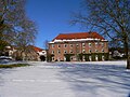
- The baroque castle (alternatively: Lower Castle or Yellow Castle ) from 1740 is located on the southern edge of the castle park. It is the former seat of the von Ebersberg family , owned by the von Waldthausen family since 1903 . Between 1996 and 2000 the building was repaired by Constantin von Waldthausen and has been used for residential, office and event purposes ever since.
- The park villa in the elevated northern part of the castle park was built in 1908 by Bruno von Waldthausen in the splendid neo -baroque style and has been a clinic for naturopathy since 1981.
- The Gersfeld riding hall, today the town hall, built in the simple neo-baroque style in the palace gardens in 1907 is famous for its open roof construction with laminated beams .
- The Gersfeld Wildlife Park is located in the Ehrengrund Valley about one kilometer southeast of the city center. It shows mainly European wild animals on an area of 50 hectares .
- The Wasserkuppe , the highest mountain in the Rhön, rises a good five kilometers north of Gersfeld. The German Gliding Museum is located on the mountain .
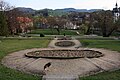
View over the castle park to the old town

Baroque castle
Middle lock

Park villa

Former riding arena (town hall)
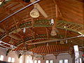
Glulam ceiling of the riding arena


_1.JPG)
_3.JPG)
Economy and Infrastructure
Economic structure

The most important source of income for the population of Gersfeld in earlier centuries was agriculture, because due to the relative poverty of natural mineral resources and the remote location far from the large urban centers, trade , mining and later industry could only develop here to a small extent. So many agricultural are still relatively Gersfeld commercial farms with intensive dairy farming exists.
However, the share of those employed in agriculture and forestry is now less than two percent. With over 50%, the tertiary sector makes up the majority of the employment structure in the municipality. The majority of the workforce can be assigned to the hotel and restaurant industry . The secondary economic sector comprises around a third of the workforce .
tourism
The rural character, the seclusion and the mild climate are advantages of the region and beneficial for tourism. Six hotels, several guest houses and over a dozen inns invite you to relax. In addition to the classics of hiking, gliding and skiing, there are also opportunities for climbing, mountain biking and playing tennis.
The Hessian long-distance cycle path R1 (Fulda cycle path ) leads through the village and this is where the summit route starts , a cycle path that connects the Hoherodskopf and Wasserkuppe .
Since 1989 the meeting of the working group Urodela (tailed amphibian) of the German Society for Herpetology and Terrarium Studies has been held in the town hall every year since 1989 .
Rail transport
Connection to the national railway network with ICE connection can be found in Fulda, from there you can reach Gersfeld by regional train. The Fulda – Gersfeld branch line , renovated in 1997 for almost twelve million euros, is the last regularly used railway line into the Rhön.
Road traffic
The federal highway 279 runs through Gersfeld, which connects the place in a westerly direction with Fulda and the federal autobahn 7 and to the southeast with the Bavarian Bischofsheim an der Rhön . In Gersfeld the federal road 284 branches off from the B 279, which leads in a north-easterly direction to Ehrenberg (Rhön) to the B 278 .
education
The Gersfeld school center is located in Gersfeld with three schools: the Otto-Lilienthal-Schule , the Anne-Frank-Schule and the Rhönschule Gersfeld , a cooperative comprehensive school . The Rhön School is the official ski performance center of the Hessian Ski Association (HSV). From 1928/29 to 2020 the Gymnastics School and Rhön Academy Schwarzerden was located in the Bodenhof on the border with Poppenhausen (Wasserkuppe) .
Personalities
sons and daughters of the town
- Sybilla von Ebersberg (1578–1622), born in Gersfeld Castle
- Walther Schönfeld (1888–1977), physician and university professor
- Hellmut Trute (1907–2007), business lawyer
- Elsa Plath-Langheinrich (* 1932), German historian and book author
- Helmut Bieler (1940–2019), composer
- Hubertus Primus (* 1955), board member of Stiftung Warentest
- Johann Adam Richter (1733–1813), master builder
- Peter Streck (1797–1864), composer, conductor and arranger
Personalities associated with the city
- Ernst Friedrich von Ebersberg (1687–1762) built the Lower Castle
- Cuno Raabe (1888-1971) was a German politician, resistance fighter and in 1946 was a member of the Constitutional Committee of Greater Hesse, took part in the constituent assembly in Hesse and was its vice-president. From 1946 to 1956 he was Lord Mayor of Fulda
- Paul von Waldthausen (1897–1965), entrepreneur, painter, photographer and interior designer
- Friedhelm Dauner (* 1945), pastor in Gersfeld and musician
People connected to the city
- Ernst Friedrich von Ebersberg (1687–1762) built the Lower Castle
- Cuno Raabe (1888-1971) was a German politician, resistance fighter and in 1946 was a member of the Constitutional Committee of Greater Hesse, took part in the constituent assembly in Hesse and was its vice-president. From 1946 to 1956 he was Lord Mayor of Fulda
- Paul von Waldthausen (1897–1965), entrepreneur, painter, photographer and interior designer
- Friedhelm Dauner (* 1945), pastor in Gersfeld and musician
literature
- Gabriele Primus: Guide through Gersfeld and the surrounding area. 2nd, modified edition. Fulda 1980.
- Literature about Gersfeld in the Hessian Bibliography
Web links
- Official website of the city of Gersfeld
- Gersfeld (Rhön), district of Fulda. Historical local dictionary for Hessen. In: Landesgeschichtliches Informationssystem Hessen (LAGIS).
- Link catalog on Gersfeld at curlie.org (formerly DMOZ )
Individual evidence
- ↑ Hessian State Statistical Office: Population status on December 31, 2019 (districts and urban districts as well as municipalities, population figures based on the 2011 census) ( help ).
- ^ Hessian Ministry for Economic Affairs, Energy, Transport and Regional Development: 80th meeting of the specialist committee for health resorts, recreation areas and healing wells in Hesse on October 14, 2014. State Gazette for the State of Hesse 7/2015, page 148
- ^ Edward Schröder: Bach names and settlement names in their relationship to one another . In: News from the Society of Sciences in Göttingen . New series, Volume III, No. 1 . Vandenhoeck & Rupprecht, Göttingen 1940, DNB 365114146 , p. 15 .
- ^ Gersfeld (Rhön), Fulda district. Historical local dictionary for Hessen. (As of September 21, 2015). In: Landesgeschichtliches Informationssystem Hessen (LAGIS).
- ^ Peace treaty between the King of Prussia and the King of Bavaria, from August 22, 1866. (No longer available online.) In: www.verfassungen.de. Archived from the original on October 26, 2017 ; accessed in December 2018 .
- ↑ Incorporation of communities into the city of Gersfeld, district of Fulda from January 7, 1971 . In: The Hessian Minister of the Interior (ed.): State Gazette for the State of Hesse. 1971 No. 4 , p. 141 , point 172 ( online at the information system of the Hessian state parliament [PDF; 6.3 MB ]).
- ↑ Law on the reorganization of the districts of Fulda and Hünfeld and the city of Fulda (GVBl. II 330-14) of July 11, 1972 . In: The Hessian Minister of the Interior (ed.): Law and Ordinance Gazette for the State of Hesse . 1972 No. 17 , p. 220 , § 7 ( online at the information system of the Hessian state parliament [PDF; 1,2 MB ]).
- ^ Federal Statistical Office (ed.): Historical municipality directory for the Federal Republic of Germany. Name, border and key number changes in municipalities, counties and administrative districts from May 27, 1970 to December 31, 1982 . W. Kohlhammer, Stuttgart / Mainz 1983, ISBN 3-17-003263-1 , p. 393-395 .
- ↑ main statute. (PDF; 791 kB) § 6. In: Website. City of Gersfeld, accessed August 2020 .
- ^ Result of the municipal election on March 6, 2016. Hessian State Statistical Office, accessed in April 2016 .
- ^ Hessian State Statistical Office: Result of the municipal elections on March 27, 2011
- ^ Hessian State Statistical Office: Result of the municipal elections on March 26, 2006
- ^ Eva-Maria Wagner: Winding streets, humpback places . In: Die Rhön (= Merian , vol. 17 (1964), booklet 4), pp. 19–24, here p. 19.
- ↑ Sights, excursion destinations in and around Gersfeld - Baroque church. In: Gersfeld.de. Retrieved March 24, 2019 .
- ^ Entry on Upper Castle Gersfeld in the private database "Alle Burgen". Retrieved June 16, 2020.
- ↑ Entry on Middle Castle Gersfeld in the private database "Alle Burgen". Retrieved June 16, 2020.
- ↑ Sights, excursion destinations in and around Gersfeld - Baroque palace. In: Gersfeld.de. Retrieved March 24, 2019 .
- ↑ Entry on Lower Castle, Gelbes Schloss Gersfeld in the private database "Alle Burgen". Retrieved June 16, 2020.
- ↑ Entry on Parkvilla Gersfeld in the private database "Alle Burgen". Retrieved June 16, 2020.
- ^ Website of the Schlosspark Clinic
- ^ Otto Lilienthal School Gersfeld. Otto-Lilienthal-Schule Gersfeld, accessed on August 25, 2020 .
- ^ Anne Frank School in Gersfeld. Anne Frank School Gersfeld, accessed on August 25, 2020 .
- ^ Rhön School Gersfeld. Rhönschule Gersfeld, accessed on August 25, 2020 .
- ↑ Promotion of Nordic skiing talent: New contract with the Rhön School Ski Performance Center. In: OsthessenNews.de. Retrieved February 11, 2018 .

Bad Salzschlirf | Burghaun | Dipperz | Ebersburg | Ehrenberg (Rhön) | Oak cell | Pus field | Lilacs | Fulda | Gersfeld (Rhön) | Grossenlüder | Hilders | Hofbieber | Hosenfeld | Hünfeld | Kalbach | Künzell | Neuhof | Nüsttal | Petersberg | Poppenhausen (Wasserkuppe) | Rasdorf | Tann (Rhön)
Altenfeld | Dalherda | Gichenbach | Hettenhausen | Maiersbach | Mosbach | Obernhausen | Rengersfeld | Rodenbach | Rommers | Sandberg | Schachen