
Fulda cycle path
| Fulda cycle path | |
|---|---|
|
|
|
| overall length | 260 km |
| location |
|
| map | |
| Link to map and elevation profile | |
| Starting point | Gersfeld ( Bf ) |
| Target point | Bad Karlshafen ( Bf ) |
| Places along the way | Ebersburg ( Bf ), Eichenzell ( Bf ), Fulda ( HBf ), Schlitz , Niederjossa , Niederaula , Bad Hersfeld ( Bf ), Ludwigsau ( Bf ), Bebra ( Bf ), Rotenburg an der Fulda ( Bf ), Alheim ( Bf ), Morschen ( Bf ), Malsfeld ( Bf ), Melsungen ( Bf ), Körle ( Bf ), Guxhagen ( Bf ), Baunatal ( Bf ), Fuldabrück , Kassel ( Bf ), Fuldatal , Hann. Münden |
| Flooring | approx. 85% asphalt, approx. 4% water-bound surface, approx. 2% concrete stone pavement, as well as split or natural floor. |
| Height difference | approx. 700 m to approx. 100 m / approx. 1150 m ascent / approx. 1850 m of descent |
| difficulty | light |
| Traffic volume | low |
| Connection to |
Rhythmic cycle path , Rhön- Sinntal-cycle path , Gipfeltour , Weser - Romantic Road (D9) , rail bike path Hesse , Hessian Radfernweg R2 , Hessian Radfernweg R3 , Hessian Radfernweg R5 , Hessian Radfernweg R7 , Eder cycle path , Werra cycle path , Weser-cycle path , Diemel cycle path |
| ADFC certification | no |
| Website URL | fuldaradweg-r1.de |
The Fulda cycle path , also called Hessischer Radfernweg R1 , is a 260 km long cycle path along the Fulda from the source on the Wasserkuppe to Hann. Münden , where Fulda and Werra unite to form the Weser , and along the Weser to the Hessian / North Rhine-Westphalian border in Bad Karlshafen. From Gersfeld in the Rhön it is also recommended for inexperienced people and families, it is mostly not suitable for racing bikes.
Characteristic
The flattest and therefore most family-friendly sections are Gersfeld - Fulda and Kassel - Hann. Münden. The rest of the way there are some hills, although the R1 is a river bike path. The route is well developed and 85% asphalted. The rest of the way leads over mostly easy to drive gravel roads. The signage is consistently present in both directions. The route is almost completely car-free. In some cases, there are also little to moderately traveled through towns. The most suitable for the route is a touring bike with gearshift suitable for mountains.
ADFC information
In the upper part before Gersfeld, the route given by the ADFC differs from that of the Hessen route plan. The ADFC route starts on the Wasserkuppe , leads past the Fulda spring to Gersfeld. In contrast, the signs for the R1 start at the end of the Ulstertal cycle path or at the Hessian / Bavarian border between Bischofsheim-Oberweißbrunn and Rodenbach as a connection to the Rhön-Sinntal cycle path .
Total length 296 km with 1613 m ascent and 2362 m descent. Approx. 10% suitable for racing bikes, a touring bike is recommended for the rest.
Difficulty: approx. 47% easy (0–2%); Remainder% medium (2-6%).
Traffic load: “no to low”; <1% mean.
The ADFC certified the Fulda Cycle Path in 2012 as a 4-star quality cycle route with only a few gentle inclines and as an ideal tour for families. The river route leads through the wooded Hessian low mountain range to the Weser and is mostly asphalted and almost car-free. Since the end of 2014, the Fulda cycle path has been starless again due to a non-recertification.
Route description

Wasserkuppe

Fulda spring at the Wasserkuppe
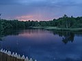
The moor pond of the red moor
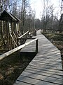
Boardwalk in the Red Moor


The distance and altitude information was taken from the Hessian cycle route planner.
Routes in the Rhön to Gersfeld
Section Wasserkuppe - Fuldaquelle - Gersfeld:
- The approx. 8 km long section starts on the highest mountain in Hesse, the Wasserkuppe ( 950 m above sea level ), leads on the L 3068 past the Fulda spring at 850 m to Gersfeld ( 492 m ). Gravel roads lead with a gradient of four to nine percent, along the young Fulda, directly to Gersfeld.
Section (R1a) Ulsterquelle - Rotes Moor - Gersfeld:
- The section marked R1a, approx. 11 km long, starts on the Rhön Cycle Path on the country road between Wüstensachsen and Oberelsbach ( 800 m ) and after 1.6 km reaches the Ulster spring at 815 m altitude. This is where the Ulster cycle path starts , which is now part of the Rhön cycle path towards Werra. The R1a leads past the Roten Moor in a westerly direction up to an altitude of 800 m before it then goes continuously downwards to Gersfeld. First with a moderate gradient through the forest and then over 4 km with up to 9%.
Section (R1) Bischofsheim in der Rhön - Gersfeld:
- The section marked R1, approx. 4 km long, starts at the Hessian / Bavarian border on the cycle path between the towns of Rodenbach and Bischofsheim in the Rhön-Oberweißbrunn, through which the Rhön-Sinntal cycle path runs and Gersfeld-Rodenbach on the Hessian side. The highest point ( 720 m ) is reached about 400 m after the state border and with inclines of up to 8% the route leads from the wooded height through meadows and fields to Gersfeld.
Gersfeld - Fulda

The Fulda in Gersfeld
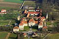
Fasanerie Castle
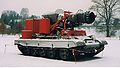
Turbo extinguisher "Hurricane" of the Fulda Fire Brigade Museum

Cathedral of St. Salvator in Fulda

Schlitz market

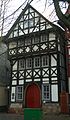
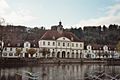
Eichhof Castle in Bad Hersfeld


.jpg)


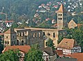
This section has a length of approx. 30 km and leads with a slight gradient from 492 m height in Gersfeld into the episcopal city of Fulda, which is about 100 meters below. The route is away from roads, partly on gravel paths. The entire section is accompanied by the Fulda – Gersfeld railway line . On weekdays, Sundays and public holidays from May to October the regional train R52 of the Hessian State Railway runs every hour (otherwise every two hours) . Eight stops offer the opportunity to continue the journey by train on the stage. Gersfeld has a historic market square with half-timbered buildings and a 50 hectare wildlife park . The route runs mainly through forest-lined meadows near the young Fulda. The route touches or crosses the villages of Altenfeld , Hettenhausen , Schmalnau , Ried and Eichenzell with its Renaissance castle in the center and the Fasanerie Castle , the former summer residence of the electorate. The junction to the center of Eichenzell is reached after approx. 21 km shortly after crossing the federal highway 66 . Then the route runs past the Eichenzell district of Lassenrod, the districts of Fulda-Bronnzell and Fulda-Johannesberg through the garden ring to the old town of Fulda. The German Fire Brigade Museum is only a few meters to the left of the cycle path in the Johannesberg district . It shows the history of German fire fighting on 1,600 m² of exhibition space . The Hessian long-distance cycle route R3 leads to the center of Fulda . There are a number of sights here, including the cathedral, the city palace with park and orangery, the Paulustor as well as the baroque quarter and many churches.
Fulda - Bad Hersfeld
This section has a length of approx. 49 km and is hilly in the upper part to Schlitz with small climbs up to max. 20 meters in altitude. The stage has a total of 188 vertical meters of ascents and 236 vertical meters of descents. There is no rail connection before Bad Hersfeld on this stage. For the most part, it is carried out on your own asphalt or concrete cycle paths or along the road. After Fulda the landscape is further shaped by meadows, fields and the river lined with trees and bushes. Passing the Kämmerzell and Lüdermünd districts of Fulda and the Pfordter bathing lake, the route reaches the Fulda bridge in the village of Pfordt after approx. 18 km . At the edge of the forest on the western bank of the Fulda, you reach the junction to Schlitz, whose high historical center is about 2 km to the west and can be reached via the Hessian long-distance cycle route R7a . The R1 continues along the road through the Fulda valley to the village of Queck . There it crosses the Fulda and leads on the eastern bank to the village of Unter-Schwarz , where the Fulda is crossed again. On the western bank, the cycle path is now continued over an old railway line towards Bad Hersfeld. After approx. 4 km the federal motorway 7 is crossed at Niederjossa and after another 4 km Niederaula is reached. The subsequent route to Asbach runs in the wide Fulda valley alternately to the right and left of the railway line, which is only used for freight traffic. Just behind Asbach is Eichhof Castle with its half-timbered courtyard, which is well worth seeing. Construction of the palace began in 1378, and today it is home to the “Landesbetriebe Landwirtschaft Hessen (LLH)” with the name “Landwirtschaftszentrum Eichhof”. From here it is another 4 km to Bad Hersfeld.
Bad Hersfeld - Melsungen
Bad Hersfeld abbey ruins
Bridge of the ICE line
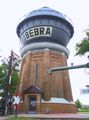
Water tower in Bebra

Rotenburg on the Fulda

Haydau Monastery

Brückenstrasse in Melsungen
Orangery in the Karlsaue in Kassel

View from the wire bridge in Kassel over the Fulda
Confluence of the Werra and Fulda to the Weser
The Weserstein in Hann. Münden


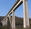
This section has a length of approx. 56 km, with climbs of 213 meters and descents of 248 meters. On this stage, numerous smaller climbs with less than 20 meters of altitude have to be overcome. During the entire stage, the route is accompanied by the railway line on which the regional train R05 of the North Hessian Transport Association runs every hour. The journey can be continued by train at eight stops. The route of the R1 leads past the city center of Bad Hersfeld near the Fulda and follows a piece of the Solztal cycle path , which is now part of the Hessen railway cycle path . After a short detour into the Solz Valley , the route returns to the Fulda after the Solzbrücke via side roads near Friedlos . Then the route between the railway line and Fulda leads to the village of Mecklar , where the railway line is crossed and it goes next to the B 27 to Bebra-Breitenbach , where about 18 km of the stage are covered. The route leads past the former Bebra railway junction . The route now leads through a partly wooded, scenic section to the half-timbered town of Rotenburg an der Fulda, 7 km away. The historic half-timbered row directly on the Fulda, the market square with the town hall and the Jakobikirche , which has been preserved in its original form, as well as the Rotenburg Castle are worth seeing . The R1 now uses several smaller local roads between Rotenburg and Melsungen. At the village of Baumbach, the Fulda is crossed in an easterly direction via a district road. Immediately afterwards, however, the route is led back to the Fulda, away from car traffic. Via fields you will then reach Altmorschen , approx. 15 km behind Rotenburg , where the former Cistercian monastery Haydau, which is very well preserved in its structural condition and through which the R1 runs, is located. Then the Fulda is crossed once again and the neighboring town of Neumorschen is crossed before the ICE line Fulda – Kassel crosses the valley at a lofty height. Behind Binsförth and before Beiseförth , the bicycle cable car , which is unique in Germany, is reached after approx. 6 km . With muscle power, the traveler and bike can transport themselves to the eastern Fuldaufer and thus avoid an ascent of around 20 meters in altitude. At the entrance to Beiseförth, the two variants meet again and continue near the river through the meadows and fields of the Fulda Valley, past Malsfeld and Obermelsungen , before the historic old town of Melsungen is reached after approx. 10 km.
Melsungen - Kassel
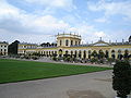
This section has a length of approx. 36 km, with climbs of 84 meters and descents of 203 meters. On the mostly flat stage there are two steeper climbs between 20 and 30 meters in altitude around Guxhagen. Smaller local roads are used for a few kilometers between Melsungen and Guxhagen. On this stage, the route is accompanied by the railway line with the regional train R05. Five stopping stations are served every hour. After Melsungen it goes again through the meadows and fields of the Fulda valley, where after approx. 12.5 km the double loop behind Körle is reached and the route changes back to the eastern bank. Guxhagen is driven through on this Fulda side and the federal motorway 7 is crossed shortly afterwards . Then after 7.5 km on the eastern side, before the village of Guntershausen , the Fuldaufer is changed again. At the edge of the forest the route now runs to Fuldabrück, where the Fulda is crossed three times in a wide double loop and then on the eastern bank past Bergshausen after approx. 11.5 km to reach the route branching in Kassel. The two variants lead about 3 km on both sides of the Fulda to Karlsaue , where they reunite. Directly at the Fulda you reach the orangery after approx. 2 km . The city center and the main train station are easy to reach from here. In Kassel, the Bergpark Wilhelmshöhe , the Karlsaue and the museum landscape invite you to visit.
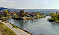
Kassel - Hann. Münden
This section has a length of approx. 29 km, with climbs of 84 meters in altitude and descents of 106 meters in altitude. This flat stage has only one notable climb in Hann. Münden, just before the confluence of the Fulda and Werra rivers, with an altitude of approx. 20 meters and an incline of approx. 2%. Between Kassel-Wolfsanger and Fuldatal-Simmershausen, the cycle path along the Fulda was expanded from February to September 2016 on the existing route over a distance of approx. 2,530 meters three meters wide. The further route to Hann. Münden is already paved. Between Fuldatal-Simmershausen and Hann. Münden, the route runs parallel to the busy B3 . There are no train stations en route on this stage. The cycle route runs from the orangery in Kassel directly on the Fulda. In the city center, the bank is changed for about 1.5 km before leaving the city on the western bank. Between the road and the bank, the route now leads at the edge of the forest through the now narrow Fulda valley and after approx. 15 km reaches Fulda valley-Wahnhausen . After a further 6 km, the route reaches Wilhelmshausen , the easternmost district of Fuldatal, after a short piece of open arable land . Then until shortly before Hann. Münden the usual picture again, on the left forest and road, on the right the Fulda. At the end of the stage, Fulda and Werra unite to form the Weser.
Hann. Münden - Bad Karlshafen
This section has a length of approx. 42 km, with ascents of 135 meters and descents of 152 meters. The flat stage has only two notable climbs between 10 and 20 meters in altitude. There is a train connection at the end of the stage in Bad Karlshafen. The route runs along large stretches on the western bank of the Weser as a cycle path alongside the B80 . The stage is also signposted as an alternative route to the Weser cycle path . According to Hann. Münden, the route leads through the meadows and fields of the river Weser, which is lined with forest on both sides, where after about 8.5 km it reaches the village of Vaake , which belongs to the municipality of Reinhardshagen. After a further 18.5 km the village of Gieselwerder follows and after another 15 km the Bad Karlshafen train station is reached.

Connecting cycle paths
- One of the starting points of the Fulda cycle path (R1) is the Rhön cycle path approx. 11 km east of Gersfeld. The Rhön cycle path with a length of 180 km leads from Bad Salzungen to Hammelburg , through all three federal states of the Rhön .
- Another starting point of the R1 is at the Hessian / Bavarian border on the cycle path between the places Rodenbach and Bischofsheim-Oberweißbrunn , through which the Rhön-Sinntal cycle path runs. The Rhön-Sinntal-Radweg leads about 118 km from Gemünden am Main to Mellrichstadt in the district of Rhön-Grabfeld .
- The summit tour , which connects Hoherodskopf and Wasserkuppe , starts in Gersfeld and runs together with the R1 over 32 km to Fulda.
- At Ebersburg-Schmalnau , the D-Route 9 meets the R1 and accompanies it for 189 km to Hann. Münden. The D-Route 9 Weser-Romantic Road leads from the North Sea via Bremen, Kassel, Fulda and the Taubertal to Füssen in Allgäu (1,197 km).
- At Ebersburg-Schmalnau, the Hessian long-distance cycle route R2 also meets the R1 and accompanies it over 32 km to shortly after Fulda. The R2 (The Four Rivers Tour) starts in Biedenkopf and leads over 202 km through the river valleys of Lahn , Lauter , Lüder and Fulda to Sinntal in the Spessart .
- Between Fulda and Schlitz (22 km) the BahnRadweg Hessen and the R1 run together and the BahnRadweg Hessen coming from the Rhön ends in Bad Hersfeld. It leads on former railway lines through the Vogelsberg and the Rhön (310 km). The volcano cycle path is part of the Hesse railway cycle path and ends in Schlitz.
- The Hessian long-distance cycle route R7 and the R1 run together between Schlitz and Bad Hersfeld . The Hessian long-distance cycle route R7 connects Werra and Taunus via the Vogelsberg (270 km).
- The R1 and the Hessian long-distance cycle route R3 cross in Fulda. The R3 runs over 258 km from Rüdesheim am Rhein along the Rhine , Main and Kinzig to Tann in the Rhön .
- The R1 and the Hessian long-distance cycle route R5 run together between Rotenburg an der Fulda and Malsfeld . The R5 leads over 234 km through the landscapes of North Hesse along the valleys of Eder, Fulda and Werra.
- In Guntershausen (Baunatal) the Eder cycle path ends on the R1. The 180 km long Eder cycle path starts in the Siegerland-Wittgenstein region.
- In Hann. The 280 km long Werratal cycle path ends in Münden and the 491 km long Weser cycle path begins , which ends in Cuxhaven .
Train and bus connections
Between Gersfeld and the Wasserkuppe, one of the possible starting points of the R1, runs four times between May and September on Sundays and public holidays. The RhönRadBus
Gersfeld can be reached via the Fulda – Gersfeld railway . In Fulda there is a connection to long-distance trains of the Deutsche Bahn . This railway line accompanies the R1 to Fulda and enables the change between cycle path and train at eight further stops. There is no train connection from Fulda to Bad Hersfeld. The Bad Hersfeld station is serviced regularly in local and long distance with lines to Frankfurt, Kassel and Göttingen. From Bad Hersfeld to Kassel the R1 is accompanied by the Fulda-Bebra and Bebra-Baunatal-Guntershausen railway lines , where 14 stops are available for changing between cycle path and train. There are further stations along the route in Kassel , Speele and Hann, among others . Münden. After that there is only a connection to the regional line towards Göttingen at the end of the R1 in Bad Karlshafen.
- See also: Infobox
Landscape and culture
The Fulda cycle path (R1) starts at various points on the heights of the Rhön and leads to Gersfeld at the southern foot of the Wasserkuppe . It is the highest mountain in Hesse and is best known as the “cradle of gliding ”. Today the gliding center consists of a paragliding school, the German Gliding Museum and the Wasserkuppe airfield for gliders and powered aircraft. An R1 variant starts on the Wasserkuppe and leads past the Fulda spring and along the young Fulda to Gersfeld. The second variant starts on the Rhön cycle path , leads past the Ulster spring and the red moor to Gersfeld. The Rote Moor is accessible to tourists by a 3 km long circular path. 1.2 km run on a plank path renewed in 2007. The plank path is also part of the Hochrhöner premium path . The path begins at the information pavilion next to the moor lake and leads in a south-north direction to the observation tower in the northern part of the Great Red Moor . From there the former peat extraction area can be seen in which fen vegetation has returned. The remaining raised bog is located to the north of the abrading edge as a protected core zone. The third variant creates the connection to the Rhön-Sinntal-Radweg and leads from the Bavarian Bischofsheim-Oberweißbrunn over a wooded ridge through meadows and fields to Gersfeld.
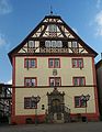
From Gersfeld with its historic market square lined with half-timbered buildings and a 50-hectare wildlife park , the path leads through the upper Fulda valley. On the way to the episcopal city of Fulda you will find the prince-bishop's summer residence Schloss Fasanerie Adolphseck in Eichenzell , in Fulda-Johannesberg the Johannesberg provost and the German Fire Brigade Museum . With the city of Fulda a cultural highlight of the R1 is reached. Now the river leaves the Rhön and runs north between the foothills of the Rhön, Vogelsberg and Knüllgebirge . In the upper reaches to the city of Fulda the valley was only 250 to 500 meters wide and had mostly steep slopes, now the valley in the middle reaches up to 1.3 km near Bad Hersfeld. Past Schlitz with its high-altitude historic town center, the route leads to the next cultural highlight, the city of Bad Hersfeld. The city lies in the Hersfeld depression , which is formed here by the confluence of the Fulda and Haune rivers . It is best known nationwide for the Bad Hersfeld Festival , which has been taking place every year since 1951 .
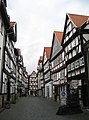
After Bad Hersfeld, the section begins with the well-known half-timbered towns such as Rotenburg an der Fulda and Melsungen, followed by Kassel, the only major city in North Hesse. The lower course of the Fulda begins at the mouth of the Eder just before Kassel. Especially in the area of the Karls- and Fuldaaue, the Fulda flows through a plain up to 3 km wide in its river valley . After Kassel she forces her way to Hann. Muzzle again through a valley that is often only a few hundred meters wide. The half-timbered town of Hann. Münden at the source of the Weser and the spa town of Bad Karlsbad with its baroque town complex round off the tour.
Attractions
Gersfeld from the castle park

Fasanerie Castle in Eichenzell

High altar of the Fulda Cathedral

Noble palace in the baroque district of Fulda

Old town hall in Fulda
Paulustor in Fulda
Schlitz market

Back tower in Schlitz
Abbey ruins with Bad Hersfeld town church
Oldest half-timbered house from 1452 in Bad Hersfeld
Rotenburg town hall
Inner courtyard of Rotenburg Castle

Jakobikirche in Rotenburg

Town hall in Melsungen
Typical half-timbering in Melsungen

Melsungen market square

Martinskirche in Kassel
Museum Fridericianum in Kassel

Wilhelmshöhe Castle
Cascades in the Wilhelmshöhe Park
Old Werra Bridge in Hann. Münden

Half-timbered ensemble in Hann. Münden
Münden town hall in Hann. Münden in the style of the Weser Renaissance
Former packing house in Bad Karlshafen


- The city of Gersfeld is a recognized climatic health resort and Kneipp spa as well as the starting point for hikes through the Rhön biosphere reserve . Most of the Haderwald in the south is closed, as the northern part of the Wildflecken military training area is located here. The city offers
- the historic market square with half-timbered buildings,
- the baroque castle from 1740 with castle park and
- the Gersfeld Wildlife Park , which is open all year round and keeps around 150 animals from 25 species on the extensive 50 hectare facility.
- In the municipality of Eichenzell, you can make a detour to Schloss Fasanerie Adolphseck . The castle, once a prince-bishop and later the electoral Hessian summer residence, was built between 1730 and 1757. The baroque complex that the Fulda prince-bishop Amand von Buseck created for himself reflects his power and love of splendor. The architect was the Italian court architect Andreas Gallasini , who was in the service of the prince-bishop . The castle and the porcelain collection, which is unique in Europe, can be visited, and during the summer there are guided tours every day except Mondays.
-
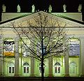
Fulda was the seat of the Fulda Monastery , is a baroque and episcopal city with the episcopal seat of the eponymous diocese . The city's landmark is St. Salvator's Cathedral . The city offers a whole range of attractions. Among other:
- The Vonderau Museum is named after the local researcher Prof. Joseph Vonderau . There are numerous finds from prehistoric times, as well as pieces from the Celtic settlement of the Fulda area . A planetarium is part of the museum .
- The German Fire Brigade Museum in Fulda-Neuenberg shows the history of German fire extinguishing on 1,600 m² of exhibition space.
- In addition to the St. Salvator Cathedral, there are many other churches. For example the parish church of St. Blaise , the Holy Spirit Church and the Severikirche .
- The city palace with park and orangery
- Baroque buildings are the Paulustor , the old town hall, the old university and the noble palace.
- The town of Schlitz was first mentioned in a document in 812. With its five castles, it is known beyond Hesse and is also known as the "Romantic Castle Town of Schlitz". A special feature is the so-called Burgenring - the inner city area of the town of Schlitz, which, lying on a hill, with its collection of castles, towers, mansions, the town church and many half-timbered houses, represents a well-preserved, closed historical ensemble. Are worth seeing among other things
- the Ev. Stadtkirche (formerly St. Margarethen), was consecrated in 812 as a three-aisled, Romanesque columned basilica,
- the market square with its half-timbered houses.
- The back tower can be "climbed" by elevator and allows a view of the entire old town. During Advent it is transformed into the largest “candle” in the world. He is wrapped in a red silk cloth and given a candle tip made of several hundred light bulbs.
- Seeburg Castle (near Hartershausen district).
- Hallenburg Castle was the residence of the Counts von Schlitz and emerged from an estate. The late baroque castle was built in the years 1706–1712. In 1954, the count's family donated the castle and park to the town of Schlitz.
- The festival and spa town of Bad Hersfeld is known nationwide primarily for its annual festival since 1951. These are held in the monastery ruins, which are considered to be the largest Romanesque church ruins in Europe. There are 216 listed buildings in the old town. The ruins of the collegiate church are located on the western side of the old town. In the monastery district there is also the Katharinenturm, in which the Lullus bell hangs, the oldest dated bell in Germany. In the center of the old town is the Gothic town church , its church tower from the 14th century is the town's landmark. The market square is lined with patrician houses from the Gothic period (including the old mint). They were rebuilt during the Renaissance and, with their gables, like the half-timbered houses opposite, bear witness to the last building bloom of the Hersfeld monastery.
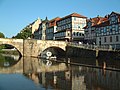
- The half-timbered town of Rotenburg an der Fulda is located south of the Stölzinger Mountains in the narrowest area of the Fulda valley. Two bridges ("Old Fulda Bridge" and "Bridge of City Partnerships") connect the old town with the new town. The main attractions of the city are:
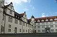
- The Rotenburg castle in the style of Renaissance , rebuilt in the years 1570-1607, rebuilt around the year 1790, including preserved outbuildings and the castle park, since 1953 state finance school Hesse .
- The three-storey town hall built between 1597 and 1598 instead of an older building. It was almost completely burned down in the Thirty Years' War , the so-called "Croatian Year" in 1637. Then the half-timbered gable was built. The portal with the cloverleaf coat of arms from the Renaissance has been preserved (dated 1598) and can still be seen today with a two-flight baroque staircase.
- The parish church of St. Jakobi named after the city's patron saint .
- The Protestant parish church (former collegiate church "St. Elisabeth and Marien") in the Neustadt was built from 1371 (inscription on the southern tower) instead of the Elisabeth Hospital.
- On the Alter Turm mountain, the ruins of Rodenberg Castle are hidden in the forest (built around 1150 by the Thuringian landgraves);
- Close to the bridge over the Fulda River is a historic weir system with a lock from the 16th and 17th centuries.
- In the area of the old town, parts of the medieval city wall from the 12th and 13th centuries with two round towers have been preserved.
- In the area of the city center interesting stone and half-timbered buildings with dwelling and some still preserved historical garden houses.
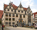
- The half-timbered town of Melsungen on the left bank of the Fulda is essentially a small town from the Middle Ages. Its main attractions are:
- the closed half-timbered ensemble in the old town area;
- the town hall from 1556, with the Bartenwetzer in the town hall tower;
- the Castle Melsungen , built in 1550-1557 under Landgrave Philip , with the castle garden
- the historic market square;
- the Bartenwetzerbrücke built from 1595 to 1596 over the Fulda;
- the Gothic town church, built between 1415 and 1425;
- the St. Georg hospital chapel;
- the oldest inn in town, the "Zur Traube", built in 1756.
- The city of Kassel was the capital of Hesse from 1277 to 1866 . The residences and castles, including Wilhelmshöhe Palace in the Bergpark, bear witness to this to this day . With the documenta , the city hosts the world's most important exhibition for contemporary art every four to five years . For this reason, Kassel has had the additional official designation "documenta city" since March 1999 . Even though, due to the war destruction and post-war urban planning, there is no longer a closed historical cityscape, due to its importance as a former residential city, the city has numerous historical buildings from many epochs, which are also dominant urban planning, including:
- The Evangelical Brethren Church is the oldest church building in the city. Located in downtown other historical monuments: Renthof with Rondell , Martin church with distinctive towers of the early postwar period, Ottoneum , Marstall , ruin of the armory, Charles Hospital , Druselturm, ruin the Garrison Church, simplifies rebuilt St. Charles Church , Fridericianum with Zwehrenturm (temporarily as observatory used ), Arbor of the former Red Palace, church tower of the old Luther Church with a modern concrete building and the surrounding grave monuments of the old town cemetery.
- The city of Kassel has important museums and galleries. The basis of today's museum landscape in Kassel was the collections of the Landgraves and Electors of Hesse-Kassel of the State Museums and Palaces and Gardens . The Fridericianum , at today's Friedrichsplatz , is considered the first public museum building on the European continent.
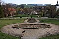
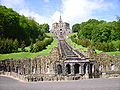
- With the Bergpark Wilhelmshöhe and the Karlsaue, Kassel is represented with two parks in the European Garden Heritage Network . In addition, the importance of the Fuldaaue as a local recreation area has grown in recent years. The Bergpark Wilhelmshöhe , which is located in the western urban area of Kassel in the Habichtswald, is a park of world renown and special beauty. The Wilhelmshöhe Palace , the Löwenburg (Kassel) and the Hercules , the symbol of the city, are located in it. The Karlsaue and the Fuldaaue are located in the Kassel Fulda lowlands . Together, these two neighboring parks form one of the largest inner-city parks and one of the most extensive local recreation areas in Germany, in which a federal garden show took place in 1955 (Karlsaue) and 1981 (Karls- and Fuldaaue) .
- In Hann. Münden is the confluence of the Werra and Fulda to the Weser . This is why the city is also known as the “three rivers city”. It has already received a number of awards for its cityscape, such as the gold medal in the federal competition for urban design and monument protection in urban development. Within the overall ensemble of the historic old town and in its surroundings, special buildings and sights are to be highlighted:
- The historic old town is rich in restored half-timbered houses (over 700 in the historic town center) and can boast medieval churches (St. Blasius, St. Aegidien). Impressive buildings from the so-called Weser Renaissance also enrich the image of the city. Particularly noteworthy are the Welfenschloss and the historic town hall.
- The St. Blasius Church is a three-aisled Gothic hall church in the center of the old town. Construction began at the end of the 13th century, and it was built on the foundations of a Romanesque basilica.
- The historic Packhof at the top of the Schlagden , which was used to handle goods on the Weser, Werra and Fulda shipping routes , has two Packhof buildings. The Packhof on the Wanfrieder Schlagd is a classicist building that was built in 1839/1840.
- The Weserstein on top of the dance Werder , at the confluence of the Werra and Fulda, is the as Weserstein called and provided with a poem boulder .
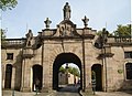
- The city of Karlshafen is the last stop of the R1. The baroque town layout with symmetrical streets is preserved impressively into disrepair. The main building, located directly on the harbor basin, is the former packing house (today the town hall) with its mighty hipped roof and central ridge turret; it was built from 1715 to 1718 and also served as representative accommodation for the landgrave when he visited.
literature
- Bikeline-Radtourenbuch Fulda-Radweg. 1: 50,000, 4th edition. Verlag Esterbauer, 2009, ISBN 978-3-85000-086-4 .
- Cycling map of the Fulda cycle path. 1: 50,000, Publicpress-Verlag, ISBN 978-3-89920-303-5 .
- Compact Spiralo-Radführer Fulda-Radweg. 1: 50,000, Bielefelder Verlagsanstalt, 2007, ISBN 978-3-87073-419-0 .
Web links
- FULDA-Radweg R1 at Regionalmanagement Nordhessen GmbH
- fuldaradweg.de Info portal on the Fulda cycle path
- Fuldaweg (Hessen R1) on radreise-wiki
swell
- Wikipedia pages and websites of the villages along the route. Accessed August 2012
Individual evidence
- ↑ a b Fuldaradweg since the beginning of 2015 again without ADFC stars on www.adfc-kassel.de, accessed on March 24, 2018
- ↑ Hessischer Radfernweg R1 on radroutenplaner.hessen.de accessed in October 2018
Coordinates: 50 ° 28 ′ 56 " N , 9 ° 55 ′ 56" E