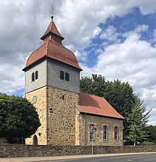
Obermelsungen
|
Obermelsungen
City of Melsungen
Coordinates: 51 ° 7 ′ 1 ″ N , 9 ° 31 ′ 38 ″ E
|
|
|---|---|
| Height : | 171 m above sea level NHN |
| Area : | 3.87 km² |
| Residents : | 723 |
| Population density : | 187 inhabitants / km² |
| Incorporation : | December 31, 1971 |
| Postal code : | 34212 |
| Area code : | 05661 |
Obermelsungen is a district of Melsungen in the north Hessian Schwalm-Eder district .
geography
Obermelsungen is 1.6 km southwest of the core city on the Kesselbach and on the Fulda in the Fulda-Werra-Bergland . The place at the Friedrich-Wilhelms-Nordbahn belongs to the North Hessian Transport Association .
history
The place was first mentioned in a document in 1151. In 1300 the village consisted of an estate and three small farms . A defensive tower was built around 1500 and a church was added to it in 1744 . A teacher is named for the place as early as 1730.
On December 31, 1971, Obermelsungen was incorporated into the city of Melsungen as part of the regional reform in Hesse . In 1975 the former school was converted into a village community center.
Population development
Source: Historical local dictionary
- 1585: 18 households
- 1747: 26 households
| Obermelsungen: Population from 1834 to 1998 | ||||
|---|---|---|---|---|
| year | Residents | |||
| 1834 | 203 | |||
| 1840 | 226 | |||
| 1846 | 223 | |||
| 1852 | 216 | |||
| 1858 | 206 | |||
| 1864 | 231 | |||
| 1871 | 247 | |||
| 1875 | 255 | |||
| 1885 | 261 | |||
| 1895 | 265 | |||
| 1905 | 272 | |||
| 1910 | 264 | |||
| 1925 | 262 | |||
| 1939 | 316 | |||
| 1946 | 508 | |||
| 1950 | 528 | |||
| 1956 | 454 | |||
| 1961 | 486 | |||
| 1967 | 490 | |||
| 1970 | 576 | |||
| 1998 | 750 | |||
| Data source: Historical municipality register for Hesse: The population of the municipalities from 1834 to 1967. Wiesbaden: Hessisches Statistisches Landesamt, 1968. Further sources:; 1970 :; City of Melsungen | ||||
Religious affiliation
Source: Historical local dictionary
| • 1885: | 261 Protestant (= 100.00%) residents |
| • 1961: | 416 Protestant (= 85.60%), 63 Catholic (= 12.96%) residents |
literature
- Literature about Obermelsungen in the Hessian Bibliography
- Search for Obermelsungen in the archive portal D of the German Digital Library
Web links
- Obermelsungen district. In: Internet presence of the city of Melsungen.
- Obermelsungen, Schwalm-Eder district. Historical local dictionary for Hessen. In: Landesgeschichtliches Informationssystem Hessen (LAGIS).
Individual evidence
- ↑ a b c d Obermelsungen, Schwalm-Eder district. Historical local dictionary for Hessen. (As of October 16, 2018). In: Landesgeschichtliches Informationssystem Hessen (LAGIS).
- ↑ a b Federal Statistical Office (ed.): Historical municipality register for the Federal Republic of Germany. Name, border and key number changes in municipalities, counties and administrative districts from May 27, 1970 to December 31, 1982 . W. Kohlhammer, Stuttgart / Mainz 1983, ISBN 3-17-003263-1 , p. 405 .

