
Kalbach
| coat of arms | Germany map | |
|---|---|---|

|
Coordinates: 50 ° 25 ' N , 9 ° 39' E |
|
| Basic data | ||
| State : | Hesse | |
| Administrative region : | kassel | |
| County : | Fulda | |
| Height : | 341 m above sea level NHN | |
| Area : | 70.64 km 2 | |
| Residents: | 6378 (Dec. 31, 2019) | |
| Population density : | 90 inhabitants per km 2 | |
| Postal code : | 36148 | |
| Primaries : | 06655, 09742 | |
| License plate : | FD | |
| Community key : | 06 6 31 016 | |
| Address of the municipal administration: |
Hauptstrasse 12 36148 Kalbach |
|
| Website : | ||
| Mayor : | Florian Hölzer (independent) | |
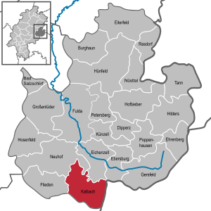
| Location of the municipality of Kalbach in the Fulda district | ||
  |
||


Kalbach is a municipality in the district of Fulda in East Hesse in the state of Hesse in the Federal Republic of Germany .
geography
Geographical location
Kalbach is located 280 to 658 meters above sea level in the southern district of the Fulda district up to the land ridge , the link between Vogelsberg in the northwest, the Rhön in the northeast and the Spessart in the south. The place itself is completely in the Rhön.
Neighboring communities
Kalbach borders in the west on the municipality of Flieden , in the northwest on the municipality Neuhof , in the northeast on the municipalities Eichenzell and Ebersburg (all four in the district of Fulda), in the east on the municipality of Motten ( district of Bad Kissingen in Bavaria ) and in the south the community of Sinntal and the city of Schlüchtern (both in the Main-Kinzig district ).
structure
The community consists of the districts Eichenried , Heubach , Mittelkalbach , Niederkalbach , Oberkalbach , Uttrichshausen and Veitsteinbach .
history
Kalbach was mentioned for the first time in 852 in a deed of donation from the Fulda monastery .
Church building
As part of the regional reform in Hesse , Veitsteinbach took on the neighboring community of Eichenried on September 1, 1969. On December 31, 1971, Heubach came to Uttrichshausen. On April 1, 1972, the previously independent communities of Niederkalbach and Veitsteinbach were incorporated into the community of Mittelkalbach. On August 1, 1972, it was merged with Oberkalbach and Uttrichshausen to form the new large municipality of Kalbach by virtue of state law . Mittelkalbach became the seat of the municipal administration.
politics
Community representation
The local elections on March 6, 2016 produced the following results, compared to previous local elections:
| Parties and constituencies |
% 2016 |
Seats 2016 |
% 2011 |
Seats 2011 |
% 2006 |
Seats 2006 |
% 2001 |
Seats 2001 |
||
|---|---|---|---|---|---|---|---|---|---|---|
| CDU | Christian Democratic Union of Germany | 44.7 | 14th | 62.0 | 19th | 62.6 | 19th | 61.2 | 19th | |
| SPD | Social Democratic Party of Germany | 35.0 | 11 | 31.6 | 10 | 31.9 | 10 | 34.0 | 11 | |
| BfK | Citizens for Kalbach | 20.2 | 6th | - | - | - | - | - | - | |
| BL | Citizen List | - | - | 6.4 | 2 | 5.5 | 2 | 4.8 | 1 | |
| total | 100.0 | 31 | 100.0 | 31 | 100.0 | 31 | 100.0 | 31 | ||
| Voter turnout in% | 65.6 | 59.7 | 58.2 | 65.1 | ||||||
mayor
Florian Hölzer (independent) was elected mayor of the municipality on September 14, 2014 with 62.8% of all votes. The turnout was 70.9%.
coat of arms
With a document dated April 4, 1976, the Hessian Minister of the Interior of the municipality of Kalbach approved the flag and coat of arms.
"The coat of arms shows behind a right split flank, in it three red rafters in gold above , a black continuous cross below in silver, a silver, seven-point chestnut leaf in blue over a lowered, golden oblique left wavy bar ."
The earlier territorial affiliations are expressed by the coats of arms of the County of Hanau and the bishopric of Fulda placed one on top of the other in the flank of the shield . The main image of the coat of arms is a seven-part chestnut leaf that alludes to the abundance of forests in the municipality and the seven districts. Attached is a stylized river with reference to the eponymous water.
Religions
Catholic Church

The area of the political community Kalbach formerly comprises four Catholic parishes , which in turn were assigned to the dean's office Neuhof-Großenlüder and the pastoral association Heilig Geist Kalbach-Neuhof in the diocese of Fulda . They are:
- St. Bonifatius in Uttrichshausen
- St. Laurentius in Niederkalbach
- St. Sebastian in Mittelkalbach
- St. Vitus in Veitsteinbach
On February 21, 2016, the four previously independent parishes were brought together in a solemn service with Auxiliary Bishop Karlheinz Diez to form the new parish of St. Kilian , Kalbach.
Protestant church
The evangelical-reformed Lukasgemeinde Kalbach is a parish of the Evangelical Church of Kurhessen-Waldeck and has its seat in Oberkalbach. In addition, the area of the parish includes the parish Heubach and Uttrichshausen.
Economy and Infrastructure

The largest solar park in the Fulda district is located in the municipality of Kalbach . The system has a total output of 365 kW and is operated by the ÜWAG subsidiary Synergie .
traffic
Through the territory of the municipality Kalbach extend federal highway 7 and the railway - Hanover-Würzburg high-speed railway . The 1298 m long Kalbach tunnel, the 773 m long Hartberg and Bornhecke tunnels and the Kalbach valley bridge (364 m) are located in the municipality. The northern quarter of the Landrückentunnel , the longest tunnel in Germany with a length of 10,779 m, is also located in the municipality.
Individual evidence
- ↑ Hessian State Statistical Office: Population status on December 31, 2019 (districts and urban districts as well as municipalities, population figures based on the 2011 census) ( help ).
- ^ Federal Statistical Office (ed.): Historical municipality directory for the Federal Republic of Germany. Name, border and key number changes in municipalities, counties and administrative districts from May 27, 1970 to December 31, 1982 . W. Kohlhammer, Stuttgart / Mainz 1983, ISBN 3-17-003263-1 , p. 376 .
- ↑ Law on the reorganization of the districts of Fulda and Hünfeld and the city of Fulda (GVBl. II 330-14) of July 11, 1972 . In: The Hessian Minister of the Interior (ed.): Law and Ordinance Gazette for the State of Hesse . 1972 No. 17 , p. 220 , § 11 ( online at the information system of the Hessian state parliament [PDF; 1,2 MB ]).
- ^ Federal Statistical Office (ed.): Historical municipality directory for the Federal Republic of Germany. Name, border and key number changes in municipalities, counties and administrative districts from May 27, 1970 to December 31, 1982 . W. Kohlhammer, Stuttgart / Mainz 1983, ISBN 3-17-003263-1 , p. 394 and 395 .
- ^ Result of the municipal election on March 6, 2016. Hessian State Statistical Office, accessed in April 2016 .
- ^ Hessian State Statistical Office: Result of the municipal elections on March 27, 2011
- ^ Hessian State Statistical Office: Result of the municipal elections on March 26, 2006
- ^ Citizens for Kalbach on the Internet
- ^ Election in Kalbach: Florian Hölzer is the new mayor in the Fuldaer Zeitung ; September 14, 2014, accessed September 17, 2014
- ↑ Starting shot for a mega solar system - up to 475,000 kWh of electricity per year In: Osthessennews from December 29, 2008.
Web links
- Website of the community
- Kalbach, district of Fulda. Historical local dictionary for Hessen. In: Landesgeschichtliches Informationssystem Hessen (LAGIS).
- Literature about Kalbach in the Hessian Bibliography
- Mayoral elections in Kalbach on statistik-hessen.de

Bad Salzschlirf | Burghaun | Dipperz | Ebersburg | Ehrenberg (Rhön) | Oak cell | Pus field | Lilacs | Fulda | Gersfeld (Rhön) | Grossenlüder | Hilders | Hofbieber | Hosenfeld | Hünfeld | Kalbach | Künzell | Neuhof | Nüsttal | Petersberg | Poppenhausen (Wasserkuppe) | Rasdorf | Tann (Rhön)