Hessian ridge
| Ridge | ||
|---|---|---|
| Highest peak | Frauenstein ( 595.6 m above sea level ) | |
| location | Main-Kinzig district and Fulda district ; Hessen ( Germany ) | |
| part of | Vorder- and Kuppenrhön (with ridge) | |
| Classification according to | Handbook of the natural spatial structure of Germany | |
|
|
||
| Coordinates | 50 ° 23 ' N , 9 ° 35' E | |
| rock | basalt | |
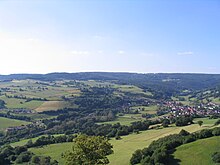
The Hessian Land Ridge (mostly just called Land Ridge ) is a roughly east-west direction, about 13 km long and to the east up to just 595.6 m above sea level. NHN high basalt ridge in the German state of Hesse . As part of the Rhine-Weser watershed , the ridge located in East Hesse is the link between the western Rhön and the eastern Vogelsberg .
geography
location
The ridge extends along the seam line of the Main-Kinzig district in the south to the Fulda district in the north, in close proximity to the Bad Kissingen district to the east , which already belongs to Bavaria . It lies north to northeast of Schlüchtern and south of Flieden , in clockwise order, between the Untere Vogelsberg in the west and northwest, the Fliedener Basin in the north, the western Rhön foreland in the northeast, the Brückenauer Kuppenrhön in the east and the Schlüchtern basin as part of the Spessart in the south.
Natural structure
The gently sloping, undulating natural area of the land ridge, which rises gently from the north and sloping sharply in the south, is part of the main unit 353, the front and the Kuppenrhön (with land ridge) , and has the code number 353.0. Its area is 57.3 km² within the boundaries of sheet 140 Schweinfurt , while the continuous basalt shield, which differs significantly from the individual peaks of the Brückenau Kuppenrhön and which also corresponds to the common demarcation, extends a little further to the east.
Outside of the mentioned eastern part with the Frauenstein, the ridge only reaches a height of over 500 m in a few places and is thus significantly lower than the low mountain range Rhön and Vogelsberg, which it connects.
Mountains and springs
Various source and tributaries of the Fliede , a tributary of the Fulda , arise on the north flank of the ridge , while the south flank feeds the Main tributary Kinzig .
Seen from east to west, the following peaks and river sources line up:
river names in italics, rivers and mountains south ("S") and north ("N") of the watershed are indented; Heights in meters (m) above mean sea level (NHN)
- Frauenstein (595.6 m)
- (N) Kalbach (to the lilac)
- (S) Schwarzbach (to Elmbach, see below)
- Sparhöfer Küppel (578.5 m)
- (N) Gemeineberg (a good 520 m)
- (N) Steinbach or Kressenwasser (to the lilac)
- Fulda wood (529.2 m, extreme east of the ridge)
- Kirschberg (507.1 m)
- Huttener Berg (510 m)
- (N) Hermannswasser (right source river of the lilac)
- (N) Kautzer Wasser (to Hermannswasser)
- (S) Elmbach (to the Kinzig)
- Escheberg (452.3 m)
- (S) Mordgraben (to the Riedbach, see below)
- Knöschen (464.5 m; not to be confused with the 508.7 m high mountain of the same name in the Gieseler Forest, 7 km to the north )
- (S) Riedbach (to the Kinzig)
- (N) Eselswasser (to Hermannswasser)
The easternmost of the mountains listed, Frauenstein and Sparhöfer Küppel , are already counted as part of the Brückenau Kuppenrhön on Blatt Schweinfurt .
Natural park
The ridge is mostly in the area of two nature parks . In the north is the ridge in the "Hessische Rhön" nature park and in the south in the "Hessischer Spessart" nature park .
railroad
Landrückentunnel
Under the ridge between Kalbach in the north and Sinntal in the south runs the longest tunnel in Germany with 10,779 m , the Landrückentunnel , which is part of the high-speed line Hanover-Würzburg .
Schluechtern tunnel (thistle lawn tunnel)
In addition, the 3.575 m long runs under the ridge at Schlüchtern Schlüchterner tunnel (also Distelrasen tunnels called), a railroad tunnel Kinzigtal web of Frankfurt am Main by Fulda .
Until its completion in 1914, the Kinzig Valley Railway crossed the ridge above ground with a hairpin at Schlüchtern-Elm . This is where the route to Gemünden connects , which crosses the ridge with several short tunnels.
Individual evidence
- ↑ a b Map services of the Federal Agency for Nature Conservation ( information )
- ↑ a b Brigitte Schwenzer: Geographical land survey: The natural spatial units on sheet 140 Schweinfurt. Federal Institute for Regional Studies, Bad Godesberg 1968. → Online map (PDF; 4.3 MB)
- ↑ Master data sheet for the ridge in the Hessen Environmental Atlas
Web links
- Description and map of the ridge (353.0) in the Hesse Environmental Atlas
- BfN landscape profile (excluding the eastern part, combined with the western Rhön foreland)

