
Künzell
| coat of arms | Germany map | |
|---|---|---|

|
Coordinates: 50 ° 32 ' N , 9 ° 42' E |
|
| Basic data | ||
| State : | Hesse | |
| Administrative region : | kassel | |
| County : | Fulda | |
| Height : | 309 m above sea level NHN | |
| Area : | 30.29 km 2 | |
| Residents: | 16,724 (Dec. 31, 2019) | |
| Population density : | 552 inhabitants per km 2 | |
| Postal code : | 36093 | |
| Primaries : | 0661, 06656 | |
| License plate : | FD | |
| Community key : | 06 6 31 017 | |
| LOCODE : | DE KZL | |
| Community structure: | eight districts | |
| Address of the municipal administration: |
Unterer Ortweg 23 36093 Künzell |
|
| Website : | ||
| Mayor : | Timo Zentgraf (independent) | |
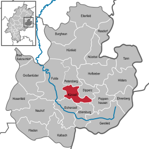
| Location of the municipality of Künzell in the Fulda district | ||
  |
||

Künzell is a suburb of Fulda in East Hesse , Germany . After the municipalities, Künzell is the largest municipality in the Fulda district .
geography
Geographical location

The community lies in the foreland of the Rhön . To the northwest, the development seamlessly merges into the city of Fulda and the community of Petersberg. The eastern part of the municipality is characterized by the mountains of the front Rhön, the highest point in the municipality is the Giebelrain . This is where the haune rises .
Expansion of the municipal area
While the districts of Künzell and Bachrain show the typical appearance of a municipality on the outskirts, the remaining districts are recognizable as closed villages embedded in the landscape.
Neighboring communities
Künzell borders in the north on the municipality Petersberg , in the east on the municipality Dipperz , in the southeast on the municipality Poppenhausen , in the south on the municipalities Ebersburg and Eichenzell , and in the west on the city of Fulda (all in the district of Fulda).
Community structure
The community of Künzell is divided into the districts Pilgerzell , Engelhelms , Dirlos (with Loheland and Dicker Turm), Dietershausen , Keulos , Wissels and Dassen . The core town itself is divided into the residential areas Künzell and Bachrain.
history

The origin of the municipality goes back to the year 743. At that time the monk Chindolf settled in the basin of the upper reaches of the Grezzbach . In the following time a cella was formed around the monk's dwelling, which was named after him Chindecella or Kindecella . Künzell was first mentioned in a document in 1160. The area was owned by the Fulda monastery. Around the year 1250, four independent farms were listed, in 1510 there were already seven.
The district of Dietershausen is first mentioned in 810 as Theotrichesus . Pilgerzell is called Biligrimcella in documents in 830 , and in 1510 Pilgerzell owned ten cattle herders . Engelhelms was mentioned in a document in 1276, Dirlos in 1318 as Villa Tyerolfes .
For centuries the church center was the Florenberg . The first documented church was built there by Abbot Huoggi (891–915) around the year 900. The defensive wall that has been preserved probably dates from the 10th century and served as protection against the invading Hungarians. The current tower is attributed to a Romanesque new building, the church interior comes from the fourth new building in 1511/1515.
Engilriches is a desert in the area of today's municipality.
Incorporations
On December 31, 1971, the previously independent communities of Dassen, Dietershausen, Keulos and Wissels were incorporated. On April 1, 1972 Dirlos, Engelhelms and Pilgerzell were added.
Population development
Until the middle of the last century, Künzell was a rural community. In 1939 only 1930 residents were registered. The economic prosperity of the region and the incorporation in 1971/72 allowed the community to grow rapidly. In 2019, 16,809 inhabitants were registered.
politics
Community representation
The local elections on March 6, 2016 produced the following results, compared to previous local elections:
| Parties and constituencies |
% 2016 |
Seats 2016 |
% 2011 |
Seats 2011 |
% 2006 |
Seats 2006 |
% 2001 |
Seats 2001 |
||
|---|---|---|---|---|---|---|---|---|---|---|
| CDU | Christian Democratic Union of Germany | 47.4 | 17th | 53.0 | 20th | 60.2 | 22nd | 60.3 | 22nd | |
| CWE | Christian voter unity e. V. | 23.5 | 9 | 16.8 | 6th | 16.2 | 6th | 15.8 | 6th | |
| GREEN | Alliance 90 / The Greens | 9.6 | 4th | 14.2 | 5 | 7.6 | 3 | 7.2 | 3 | |
| SPD | Social Democratic Party of Germany | 13.2 | 5 | 12.8 | 5 | 13.3 | 5 | 16.6 | 6th | |
| FDP | Free Democratic Party | 6.3 | 2 | 3.2 | 1 | 2.7 | 1 | - | - | |
| total | 100 | 37 | 100 | 37 | 100 | 37 | 100 | 37 | ||
| Voter turnout in% | 50.7 | 47.9 | 41.6 | 50.5 | ||||||


coat of arms
The coat of arms was approved on September 5, 1973 by the Hessian Ministry of the Interior.
Blazon : "The shield, made of green and silver by a silver-black squared cross, shows a silver lily in the 1st and 4th fields in green and a green fir tree in the 2nd and 3rd field in silver."
The coat of arms was designed by the heraldist Heinz Ritt from Bad Nauheim.
Town twinning
Town twinning has existed with the communities of Dingelstädt in Eichsfeld / Thuringia since 1960 and Rustington in West Sussex / Great Britain since 2002.
Buildings
.jpg)
- The Florenberg (382 m) is a striking elevation with a church from 1362 that can be seen from afar.
- The fortified church of St. Bartholomew in Dietershausen with late Gothic frescoes.
- Thick tower is the name of a medieval waiting and signal tower. Its platform at 382.78 meters above sea level offers a view of the Rhön , the Vogelsberg and the city of Fulda .
- The renovation of the town hall as part of the economic stimulus program in 2009 cost the municipality of Künzell the amount of 3.37 million euros instead of the estimated sum of 1.66 million euros, which led to a critical discussion in the municipal council in 2012. In 2013, the taxpayers' association took up the case and published its criticism of the construction project in its annually published black book.
- The "New Center" of Künzell was largely completed by autumn 2014 and inaugurated on September 13, 2014.
Economy and Infrastructure
traffic
Künzell is located at exit 92 Fulda-Mitte of the A 7 Würzburg – Kassel and the Fulda-Künzeller Strasse exit of the B 27 , via which the Fulda-Süd exit of the A 66 Frankfurt – Fulda can also be reached.
The Fulda train station, an important traffic junction with an ICE train station between Frankfurt am Main, Kassel, Erfurt and Würzburg, is a few kilometers away and easily accessible with the buses of the Rhein-Main-Verkehrsverbund (RMV).
Public facilities
The Deutsche Rentenversicherung Hessen has set up an office in Künzell since 2000 (information and advice center, service center for rehabilitation, medical examination center and test district center) for East Hesse with 300 employees.
education

Künzell offers nine kindergartens as well as the two primary schools Theotrichschule in Dietershausen and Florenbergschule in Pilgerzell and the primary and secondary school Don-Bosco-Schule in Künzell.
The Rudolf Steiner School is a free Waldorf school in Loheland that works as a comprehensive school . The Loheland Academy also trained to become a state-certified gymnastics teacher based on Loheland gymnastics until 2009 .
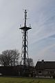
Transmitters
In Künzell there are two free-standing steel framework structures, the 68 meter high Künzell transmission tower of the Hessian Broadcasting Corporation and the 43 meter high Künzell telecommunications tower of the Deutsche Telekom AG. There is also a radio tower for the fire brigade.
In an open area at 50.535942 N 9.720422 O, the medium-wave transmitter of the AFN Fulda was once located.

Künzell transmission tower of the Hessian Broadcasting Corporation
Telecommunication tower Künzell

Radio tower of the fire brigade in Künzell

Uh Location of the AFN medium wave transmitter


Established businesses
Thanks to its central location within Germany, there are companies based in Künzell that operate nationwide and across Germany. There are around 1,200 companies and businesses in Künzell. Many traditional manufacturers and innovative companies are based in Künzell. There is an overview of the company structure on the Künzeller website.
Sons and daughters of the church
- Hubert Heil (1931–2019), member of the Hessian state parliament (CDU) and union chairman
- Rudolf Grösch (* 1944), politician (B'90 / Greens)
- Patrik Sinkewitz (* 1980), professional cyclist
Individual evidence
- ↑ Hessian State Statistical Office: Population status on December 31, 2019 (districts and urban districts as well as municipalities, population figures based on the 2011 census) ( help ).
- ^ Federal Statistical Office (ed.): Historical municipality directory for the Federal Republic of Germany. Name, border and key number changes in municipalities, counties and administrative districts from May 27, 1970 to December 31, 1982 . W. Kohlhammer GmbH, Stuttgart / Mainz 1983, ISBN 3-17-003263-1 , p. 393 .
- ^ Result of the municipal election on March 6, 2016. Hessian State Statistical Office, accessed in April 2016 .
- ^ Hessian State Statistical Office: Result of the municipal elections on March 27, 2011
- ^ Hessian State Statistical Office: Result of the municipal elections on March 26, 2006
- ↑ Case from the Black Book 2013 - Rushed renovation of the town hall ( memento from October 23, 2013 in the Internet Archive )
- ^ Schools in the Fulda district
literature
- 850 years of Künzell - from monks' cells to a friendly community - development of a village from 1165 to 2015 , publisher: Künzell community, 750 copies
Web links
- Internet presence of the community of Künzell
- "Künzell, District of Fulda". Historical local dictionary for Hessen. In: Landesgeschichtliches Informationssystem Hessen (LAGIS).
- Literature about Künzell in the Hessian Bibliography
- Link catalog on the topic of Künzell at curlie.org (formerly DMOZ )

Bad Salzschlirf | Burghaun | Dipperz | Ebersburg | Ehrenberg (Rhön) | Oak cell | Pus field | Lilacs | Fulda | Gersfeld (Rhön) | Grossenlüder | Hilders | Hofbieber | Hosenfeld | Hünfeld | Kalbach | Künzell | Neuhof | Nüsttal | Petersberg | Poppenhausen (Wasserkuppe) | Rasdorf | Tann (Rhön)