
Ehrenberg (Rhoen)
| coat of arms | Germany map | |
|---|---|---|
.png)
|
Coordinates: 50 ° 30 ' N , 10 ° 0' E |
|
| Basic data | ||
| State : | Hesse | |
| Administrative region : | kassel | |
| County : | Fulda | |
| Height : | 632 m above sea level NHN | |
| Area : | 40.84 km 2 | |
| Residents: | 2564 (Dec. 31, 2019) | |
| Population density : | 63 inhabitants per km 2 | |
| Postal code : | 36115 | |
| Primaries : | 06683 (Wüstensachsen, Melperts, Seiferts), 06681 (Thaiden, Reulbach) | |
| License plate : | FD | |
| Community key : | 06 6 31 005 | |
| Address of the municipal administration: |
Rhönstrasse 26 36115 Ehrenberg (Rhön) |
|
| Website : | ||
| Mayor : | Peter Kirchner ( independent ) | |
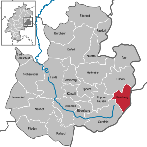
| Location of the municipality of Ehrenberg (Rhön) in the Fulda district | ||
 _in_FD.svg) |
||

Ehrenberg (Rhön) is a municipality with about 2700 inhabitants in the Fulda district in the East Hessian Rhön .
geography
Geographical location
The community is located around the 817 m high Ehrenberg , a northeast branch of the Wasserkuppe , centrally in the Hessische Rhön Nature Park and in the Rhön Biosphere Reserve at an altitude of 450 to 900 meters, about 30 km east of Fulda . Most of the districts of the municipality are located in the Ulster valley and are crossed by the federal road 278 . Only Reulbach is in a neighboring valley.
Neighboring communities
Ehrenberg borders in the north on the community of Hilders (district of Fulda), in the east on the community of Birx (in the Thuringian district of Schmalkalden-Meiningen ), the town of Fladungen , the community of Hausen and the market town of Oberelsbach (all three in the district of Rhön-Grabfeld in Bavaria ) , in the south to the city of Gersfeld , and in the west to the municipality of Poppenhausen (both in the district of Fulda).
Districts
The districts of Ehrenberg are Wüstensachsen (administrative headquarters), Seiferts , Reulbach , Thaiden and Melperts . Their districts are spread over an area of 40.83 km², of which 29.12% are forest and 61.65% are agricultural areas.
Melperts
- Population: 141 inhabitants (2017)
- Mayor: Winfried Schiffhauer
- average altitude: 540 m above sea level NN
The smallest place in the municipality is predominantly agricultural. The center of the village is the bakery with the village square, where the annual Melpertser bakehouse festival takes place. Melperts owns a pottery, a farm shop and a Haflinger farm.
Reulbach
- Population: 369 inhabitants (2017)
- Mayor: Dominik Reith
- average altitude: 570 m above sea level NN
The district Reulbach is located in the valley basin of the Reulbach surrounded by the Schafstein and the Ehrenberg at the foot of the Wasserkuppe. The beech forests of Bornberg extend to the outskirts. The basalt block sea of the Schafstein as well as the summer toboggan run and the Rhönbob on the fairy tale meadow of the Wasserkuppe are easy to hike. Circular hiking trails lead from the Bornberg car park over the Ehrenberg, past the Martinskapelle, and through the Schafstein nature reserve with its "primeval forest".
Seiferts
- Population: 600 inhabitants (2017)
- Mayor: Andreas Schuldt
- average altitude: 530 m above sea level NN
Seiferts, the second largest town in the municipality, has about 560 inhabitants and is between 520 and 540 m above sea level. NN. To the west of the village lies the confluence of the Birxgraben and Ulster, directly on the Ehrenberg, which is 816 meters high. From the east Seiferts is towered over by the Billstein, to the south and north the Ulstertal extends. Important buildings are today's cemetery chapel from 1642, the church built in 1879 and the village community center with fire station built in 1994. Seiferts has a pronounced club life.
Thaiden

- Population: 277 inhabitants (2017)
- Mayor: Martin Barthelmes
- average altitude: 500 m above sea level NN
At the foot of the Krautberg and the Teufelsberg, the district of Thaiden is the northernmost district of Ehrenberg, also in the Ulstertal. It is predominantly agricultural and touristic. Even the basalt mining , as well as its processing into various concrete elements and paving stones dot the village. A model garden and a museum on the FCN site (Franz Carl Nüdling, Basaltwerke GmbH & Co KG Holding) provide information about the history of basalt mining and the geology of the Rhön.
Desert saxons
- Population: 1,237 inhabitants (2017)
- Mayor: Manfred Stumpf
- average altitude: 580 m above sea level NN
Wüstensachsen was the end point of the Götzenhof – Wüstensachsen railway line .
In 1965, desert Saxony was recognized as a resort. Since 1983 it has been a state-approved climatic health resort with a corresponding infrastructure.
In November 1993 the community of Ehrenberg was named a "family-friendly holiday resort".
Sports fields, a mini golf course and in winter cross-country skiing trails and ski lifts are available for those who do sport. On the nearby Wasserkuppe, hang-gliders, model, glider or paraglider pilots will find their starting points. There is also an outdoor pool , a Kneipp pool , several walking paths with many benches and around 150 km of marked hiking trails. Guided tours are offered through the Red Moor and Black Moor nature reserves .
The nature reserves Kesselrain and Schafstein (832 m) (with the largest basalt boulder sea in the Rhön ) and the Steinkopf (888 m) are among the geological features of the community.
history
Church building
In the course of the regional reform in Hesse , on December 31, 1970, the previously independent communities of Melperts, Seiferts and Wüstensachsen merged on a voluntary basis to form the new community of Ehrenberg. Wüstensachsen became the seat of the municipal administration. Reulbach and Thaiden were added on August 1, 1972 by virtue of state law. The community got its name from the 817 m high Ehrenberg , which rises in the center of its area. For all formerly independent municipalities, local districts with local advisory boards and local councilors were formed in accordance with the Hessian municipal code.
politics
Community representation
The local elections on March 6, 2016 produced the following results, compared to previous local elections:
| Parties and constituencies |
% 2016 |
Seats 2016 |
% 2011 |
Seats 2011 |
% 2006 |
Seats 2006 |
% 2001 |
Seats 2001 |
||
|---|---|---|---|---|---|---|---|---|---|---|
| BLE | Ehrenberg citizens list | 49.8 | 7th | 47.2 | 7th | 46.8 | 7th | 47.7 | 7th | |
| CDU | Christian Democratic Union of Germany | 31.4 | 5 | 30.8 | 5 | 38.5 | 6th | 36.2 | 6th | |
| SPD | Social Democratic Party of Germany | 18.8 | 3 | 22.1 | 3 | 14.6 | 2 | 16.1 | 2 | |
| total | 100.0 | 15th | 100.0 | 15th | 100.0 | 15th | 100.0 | 15th | ||
| Voter turnout in% | 69.1 | 64.0 | 60.5 | 71.9 | ||||||
Districts
The following local districts with local advisory board and local councilor according to the Hessian municipal code exist in the municipality:
- Local district Wüstensachsen (areas of the former municipality Wüstensachsen ). The local advisory board consists of five members.
- Melperts district (areas of the former Melperts municipality ). The local advisory board consists of five members.
- Seiferts district (areas of the former Seiferts municipality ). The local advisory board consists of five members.
- Local district Thaiden (areas of the former municipality Thaiden ). The local advisory board consists of five members.
- Reulbach district (areas of the former Reulbach community ). The local advisory board consists of five members.
coat of arms
The coat of arms of the municipality of Ehrenberg shows the red Franconian rake , the upper border of which is set off in silver. The raised central point of the rake, which indicates the former affiliation to Franconia , is intended to emphasize the special low mountain range in the Hohe Rhön. The silver thistle is to be seen as a symbol of the local flora.
Sons and daughters of the church
- Johannes Kirsch (1930–2015) - sculptor , wood carver and medalist
- Claudia von Gélieu (* 1960 in Melperts as Claudia Faulstich) - author and women's history researcher in Berlin
- Josef Walburg (1924-2006) - wood sculptor
- Tanja Röder (* 1975 in Ehrenberg) - master wood sculptor with a studio in Pfaffenhofen an der Ilm
- Neidhardt von Thüngen (1545–1598) - Prince-Bishop of the Bamberg Monastery
Others
Ehrenberg is located in the “ Star Park in the Rhön Biosphere Reserve” recognized by the Dark Sky Association in 2014 . Some designated observation areas in this light protection area are in the immediate vicinity.
In January 2017, Ehrenberg was described in the ARD Tagesthemen as a “place that came out of a picture book”. The satisfied and mostly happy residents are impressive.
literature
- Bruno Faulstich: Melpertser story (s). Ehrenberg 2006
- Reulbach local advisory board (ed.): Rügelberk becomes Reulbach. Ehrenberg 2003.
- Ehrenberg community (ed.): The Jewish community of Wüstensachsen. 1998.
Individual evidence
- ↑ Hessian State Statistical Office: Population status on December 31, 2019 (districts and urban districts as well as municipalities, population figures based on the 2011 census) ( help ).
- ↑ a b c d e data from the municipality of Ehrenberg (Rhön) , accessed on January 28, 2018
- ↑ Amalgamation of communities to form the community "Ehrenberg", district of Fulda on January 7, 1971 . In: The Hessian Minister of the Interior (ed.): State Gazette for the State of Hesse. 1971 No. 4 , p. 140 , point 161 ( online at the information system of the Hessian state parliament [PDF; 6.3 MB ]).
- ↑ Law on the reorganization of the districts of Fulda and Hünfeld and the city of Fulda (GVBl. II 330-14) of July 11, 1972 . In: The Hessian Minister of the Interior (ed.): Law and Ordinance Gazette for the State of Hesse . 1972 No. 17 , p. 220 , § 6 ( online at the information system of the Hessian state parliament [PDF; 1,2 MB ]).
- ^ Federal Statistical Office (ed.): Historical municipality directory for the Federal Republic of Germany. Name, border and key number changes in municipalities, counties and administrative districts from May 27, 1970 to December 31, 1982 . W. Kohlhammer, Stuttgart / Mainz 1983, ISBN 3-17-003263-1 , p. = 393 and 395 .
- ^ Website of the municipal administration , accessed on August 19, 2019
- ↑ a b main statute. (PDF; 120 kB) § 5. In: Website. Ehrenberg community, accessed in August 2020 .
- ^ Result of the municipal election on March 6, 2016. Hessian State Statistical Office, accessed in April 2016 .
- ^ Hessian State Statistical Office: Result of the municipal elections on March 27, 2011
- ^ Hessian State Statistical Office: Result of the municipal elections on March 26, 2006
- ↑ Master wood sculptor Tanja Röder: ATELIER - GALERIE Tanja Röder - wood, stone, bronze. Retrieved June 7, 2017 .
- ↑ Rhön Star Park officially recognized | Internet portal Rhön. Retrieved January 29, 2017 .
- ↑ Rhön Marketing: Star Park Rhön | The Rhön | Catalog order. Retrieved January 29, 2017 .
- ↑ tagesschau.de: What moves Germany : What life is like in Ehrenberg in the Rhön. (No longer available online.) Archived from the original on January 28, 2017 ; accessed on January 28, 2017 . Info: The archive link was inserted automatically and has not yet been checked. Please check the original and archive link according to the instructions and then remove this notice.
Web links
- Website of the municipal administration
- Ehrenberg (Rhön), Fulda district. Historical local dictionary for Hessen. In: Landesgeschichtliches Informationssystem Hessen (LAGIS).
- Link catalog on Ehrenberg at curlie.org (formerly DMOZ )

Bad Salzschlirf | Burghaun | Dipperz | Ebersburg | Ehrenberg (Rhön) | Oak cell | Pus field | Lilacs | Fulda | Gersfeld (Rhön) | Grossenlüder | Hilders | Hofbieber | Hosenfeld | Hünfeld | Kalbach | Künzell | Neuhof | Nüsttal | Petersberg | Poppenhausen (Wasserkuppe) | Rasdorf | Tann (Rhön)