Steinkopf (Desert Saxony)
| Stone head | ||
|---|---|---|
|
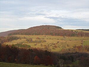
Stone head from the west |
||
| height | 888 m above sea level NHN | |
| location | near Ehrenberg ; District of Fulda , District of Rhön-Grabfeld ; Hessen , Bavaria ; Germany | |
| Mountains | Rhön (Hohe Rhön / Long Rhön) | |
| Coordinates | 50 ° 28 ′ 41 ″ N , 10 ° 1 ′ 5 ″ E | |
|
|
||
| Type | extinct volcano | |
| rock | basalt | |
| Age of the rock | 25 - 11 mya / Miocene | |
| Development | Forest, forest and hiking trails and paths | |
The Steinkopf at Wüstensachsen is 888 m above sea level. NHN high mountain of volcanic origin in the Rhön . The area around the stone head is an ecologically valuable area, therefore strictly protected and natural. On the mountain there are damp and poor mountain meadows that are used as high pasture .
geography
Geographical location
The summit of the Steinkopf is located in Hesse , in the Fulda district , 2.7 km southeast of Wüstensachsen , the capital of the Ehrenberg community . The border with the Rhön-Grabfeld district in Bavaria runs around 500 m to the east . The Hessian Rhön and Bavarian Rhön nature parks meet along this border . The Steinkopf is a core zone in the Rhön Biosphere Reserve . In the valley to the west of the mountain, the upper reaches of the Ulster near the source are located within a nature reserve . The Hochrhönstrasse runs on its south-eastern flank . Neighboring mountains are the Stirnberg in the northeast and the Heidelstein in the south.
Natural space
The Steinkopf belongs to the natural area Lange Rhön (section number 354.11), which is part of the main unit Hohe Rhön (no. 354) in the main unit group Osthessisches Bergland (no. 35).
Watershed
The Rhine-Weser watershed runs over the Steinkopf . The water of the short streams , which run from the mountain to the west, northwest and north, flows over the Ulster into the eastern Weser source river Werra . That of the Oberelsbacher Graben , which rises on its eastern flank, runs through Bahra , Streu , Franconian Saale and Main into the Rhine . The Els (Elsbach), which rises to the south-east of the nearby Heidelstein and is fed by a few streams coming from the Steinkopf, flows into the Streu, making it part of the Rhine catchment area .
geology
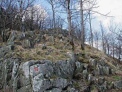
The Steinkopf is a weathered, former volcanic vent - similar to the nearby Schafstein . It originated in the Miocene , the most recent age of the Neogene about 25 to 11 million years ago (formerly Young Tertiary ). The solid basalt was carved out by weathering , and a pile of rubble formed on its east side . The wooded western slope drops steeply into the Ulstertal.
Flora and fauna

Due to its exposed location, its great unspoilt nature and its close interlinking of various forest communities and rock heaps typical of the Rhône, the Steinkopf is an important location for rare animal and plant species, some of which are of supraregional importance. The research is not yet complete, relics of Ice Age settlement are suspected.
The rubble dump of the nearby summit region is mainly covered with summer linden - sycamore maple - slope or block rubble forest , the other areas with beech forest; the rest of the hilltop area is predominantly unwooded and serves as a hat area. Particularly noteworthy are rare mosses and lichens .
The stone head is a habitat for woodcock , cuckoo and sparrowhawk . The imperial mantle , milk spot and brown eye are rare butterfly species . Club snails and gray door snails have been identified as snails . Crevices and hollows of old trees are ideal habitats for small animals such as woodpeckers , bats and wild bees .
On rare plants z. B. the rock bird cherry , the yellow blooming wolf monkshood , the alpine milk lettuce , the broad-leaved bellflower and the spring cup . For example, a deciduous moss grows on the rocks and stone blocks, which is otherwise only found in the Alps and the southern Black Forest.
Care plan
Biosphere Reserve core zone
The core zone of the Rhön Biosphere Reserve located at the Steinkopf is a so-called "stepping stone" between the neighboring core zones Stirnberg (north), Kesselrain (on Heidelstein ; south) and Schafstein (northwest), with Schafstein being the furthest at 4.3 km (as the crow flies) away from the stone head.
The maintenance plan for this core zone provides for a buffer strip around the protected area towards the Hute in order to prevent the entry of fertilizers and other substances. Attempts are made to use the area , which is difficult to access, but is nevertheless important for nature and landscape protection , and to maintain it in the long term.
Grassland project at Steinkopf
The project “Grassland protection and landscape development through large-scale grazing” , in short: Grassland project of the Rhön Biosphere Reserve, aims to increase the profitability of small-scale farms in addition to landscape maintenance. The project sponsor is the Rhön working group with the districts; it is also funded by the German Federal Environmental Foundation and the Frankfurt Zoological Society (ZGF).
Various farmers have been forming a pasture community since spring 2006 and want to cultivate around 110 hectares on the Steinkopf together with around 90 cows and 80 calves. There is also grazing with Rhön sheep and goats . The aim is for the animals to remain on the area during the grazing period. This could make the progressive encroachment of the nature conservation-relevant area at the Steinkopf a thing of the past.
See also
Remarks
- ↑ Map services of the Federal Agency for Nature Conservation ( information )
- ↑ Core zone: area in biosphere reserves excluded from any use (e.g. agriculture and forestry)
- ↑ "Stepping stone": an alternating area for migratory animal species (including birds)


