Streu (Franconian Saale)
| Litter | ||
|
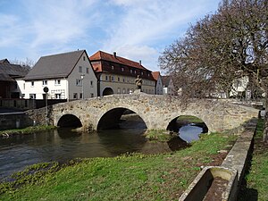
The Streu (rear) flows into the Franconian Saale (from right to front) |
||
| Data | ||
| Water code | EN : 2442 | |
| location |
Rhön
|
|
| River system | Rhine | |
| Drain over | Franconian Saale → Main → Rhine → North Sea | |
| source | in the Rhön near the mountain elbow 50 ° 33 ′ 59 ″ N , 10 ° 5 ′ 28 ″ E |
|
| Source height | approx. 740 m above sea level NN | |
| muzzle | at Heustreu in the Franconian Saale Coordinates: 50 ° 20 ′ 38 ″ N , 10 ° 15 ′ 23 ″ E 50 ° 20 ′ 38 ″ N , 10 ° 15 ′ 23 ″ E |
|
| Mouth height | 230 m above sea level NN | |
| Height difference | approx. 510 m | |
| Bottom slope | approx. 12 ‰ | |
| length | 41.9 km | |
| Catchment area | 447.86 km² | |
| Discharge at the Nordheim gauge in front of the Rhön. Location: 26.1 km above the mouth |
NNQ MNQ MQ MHQ HHQ (1978) |
63 l / s 121 l / s 893 l / s 22.6 m³ / s 41.4 m³ / s |
| Discharge at the Unsleben gauge (97.0% of the catchment area). Location: 3.8 km above the estuary |
NNQ MNQ MQ MHQ HHQ (2003) |
204 l / s 763 l / s 3.72 m³ / s 49.9 m³ / s 106 m³ / s |
| Left tributaries | Sulz , Mahlbach , Bähra | |
| Right tributaries | Bahra , Els | |
| Small towns | Fladungen , Mellrichstadt , Ostheim / Rhön | |
The Streu is an orographic right and northern tributary of the Franconian Saale in Thuringia and Bavaria ( Germany ), almost 42 kilometers long .
Surname
The name Streu was written "Steuue" in the 8th century and "Strouua" around 1030. It is derived from the Lithuanian word strove , which means strong current. The river gave the municipalities Oberstreu and Heustreu and the village Mittelstreu their names.
geography
course
The litter rises in the Thuringian part of the Rhön, southeast of the mountain Ellenbogen . It flows roughly in a north-south direction. From the source the river runs first in a south-easterly direction over the state border to Bavaria to the city of Mellrichstadt . There the Streu changes its course and flows about 10 km in a south-westerly direction until it flows into the somewhat smaller Franconian Saale, a right tributary of the Main, at the municipality of Heustreu .
On a map from 1621, the entire course of the river to Gemünden bears the name "Straÿ Flu" (Streu River).
Tributaries
- Dorfbach ( right ), Fladungen -Oberfladungen, 411 m above sea level. NN
- Leubach ( right ), Fladungen ( 7.86 km ), 395 m above sea level. NN
- Klingsgraben ( left ), Fladungen, 394 m above sea level. NN
- Reuthgraben ( right ), Fladungen-Heufurt, 374 m above sea level. NN
- Eisgraben ( right ), Nordheim vor der Rhön ( 10.22 km ), 345 m above sea level. NN
- Märzengraben ( left ), Nordheim vor der Rhön, 324 m above sea level. NN
- Bahra ( right ), Nordheim vor der Rhön ( 4.59 km ), 318 m above sea level. NN
- Sulz ( left ), Stockheim ( with Schlürpf 11.83 km ), 279 m above sea level. NN
- Gerlachsgraben ( right ), Mellrichstadt , 264 m above sea level. NN
- Mahlbach ( left ), Mellrichstadt ( 12.64 km ), 260 m above sea level. NN
- Wiesentalgraben ( right ), Mellrichstadt, 257 m above sea level. NN
- Blutgraben ( left ), Mellrichstadt, 256 m above sea level. NN
- Bahra ( Brahn ) ( left ), Oberstreu -Mockenmühle ( 12.9 km ), 251 m above sea level. NN
- Eidersgraben ( left ), Oberstreu- Mittelstreu, 248 m above sea level. NN
- Stebachgraben ( right ), Oberstreu-Mittelstreu, 241 m above sea level. NN
- Eckartsgraben ( left ), Unsleben , 240 m above sea level. NN
- Lohngraben ( left ), Unsleben, 239 m above sea level. NN
- Els ( right ), Unsleben ( 21.58 km ), 238 m above sea level. NN
- Wollbach ( right ), Heustreu , 235 m above sea level. NN
River system
fauna
In the stray come grayling , brown trout , brook lamprey , brook trout , loach , gudgeon , minnow , hazel , bullhead , rainbow trout , roach and three-spined stickleback before.
Web links
Individual evidence
- ↑ a b List of brook and river areas in Bavaria - Main river area, page 94 of the Bavarian State Office for the Environment, as of 2016 (PDF; 3.3 MB)
- ↑ Bavarian flood news service (as of September 6, 2011)
- ^ Wolf-Armin von Reitzenstein : Lexicon of Franconian place names. Origin and meaning . Upper Franconia, Middle Franconia, Lower Franconia. CH Beck, Munich 2009, ISBN 978-3-406-59131-0 , p. 102, 171 ( 171 # v = onepage restricted preview in the Google book search).
- ↑ Subtraction of MQ level salt (8.61 m³ / s) - MQ level Schweinhof (1.59 m³ / s) - MQ level Unsleben (3.72 m³ / s). The mean value calculated from this is not representative and does not reflect the long-term hydrological conditions.
- ^ Map of Franckenland (Hondius, Jodocus: Atlas minor; 431)
- ↑ Fishing Association of Lower Franconia: Our Waters ( Memento of the original from September 25, 2014 in the Internet Archive ) Info: The archive link was automatically inserted and not yet checked. Please check the original and archive link according to the instructions and then remove this notice.


