
Haystack
| coat of arms | Germany map | |
|---|---|---|

|
Coordinates: 50 ° 21 ' N , 10 ° 15' E |
|
| Basic data | ||
| State : | Bavaria | |
| Administrative region : | Lower Franconia | |
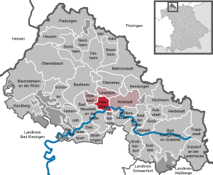
| County : | Rhön-Grabfeld | |
| Management Community : | Haystack | |
| Height : | 232 m above sea level NHN | |
| Area : | 10.56 km 2 | |
| Residents: | 1291 (Dec. 31, 2019) | |
| Population density : | 122 inhabitants per km 2 | |
| Postal code : | 97618 | |
| Area code : | 09773 | |
| License plate : | NES, CAN, MET | |
| Community key : | 09 6 73 133 | |
| Community structure: | 2 districts | |
| Address of the municipal administration: |
Municipality of Heustreu Wetterstr. 4 97618 Heustreu |
|
| Website : | ||
| Mayor : | Ansgar Zimmer ( CSU / Free Voting Community ) | |
| Location of the municipality of Heustreu in the Rhön-Grabfeld district | ||
  |
||

Heustreu is a municipality and a village in the Lower Franconian district of Rhön-Grabfeld and the seat of the Heustreu administrative community .
geography
The place of the same name is located in the Main-Rhön region on the Streu .
Community structure
There are two districts:
- Haystack
- Meadow mill
There is only the district Heustreu.
Surname
etymology
The name Heustreu is derived from the Streu river that flows through the municipality and flows into the municipality of the Franconian Saale . The addition of hay ( mhd. Höuwe ) and at times Niedern was intended to distinguish the village from the northeastern towns of the same name.
Earlier spellings
Earlier spellings of the place from various historical maps and documents:
|
|
history
Until the church is planted
The first documentary mention took place in the year 1057. The office of the Hochstift Würzburg belonged from 1500 to the Franconian Empire . After secularization in 1803 in favor of Bavaria, it was left to Archduke Ferdinand of Tuscany in 1805 to form the Grand Duchy of Würzburg and with this in 1814 it finally fell to Bavaria. In 1818 the political municipality was established.
Population development
- 1970: 1128 inhabitants
- 1987: 1157 inhabitants
- 1991: 1228 inhabitants
- 1995: 1390 inhabitants
- 2000: 1459 inhabitants
- 2005: 1296 inhabitants
- 2010: 1215 inhabitants
- 2015: 1252 inhabitants
politics
Mayor is Ansgar Zimmer (CSU / Free Voting Association), his deputy is Markus Werner. In 2014 Zimmer succeeded Walter Weber (CSU / Free Voting Community). The municipal council has 13 members including the mayor. All members belong to the CSU / Free Voting Community.
coat of arms
|
|
Blazon : "Two golden swords of flame crossed at an angle over a lowered silver shaft." |
Architectural monuments
Economy and Infrastructure
Economy including agriculture and forestry
In 1998, according to official statistics, there were 258 people in the manufacturing sector and no employees in the trade and transport sector who were subject to social security contributions at the place of work. In other economic sectors, 44 people were employed at the place of work subject to social security contributions. There were a total of 1,031 employees at the place of residence subject to social security contributions. There were two companies in the manufacturing sector and eight in the construction sector. In addition, in 1999 there were 76 farms with an agricultural area of 1746 hectares, of which 1438 hectares were arable land.
education
There are the following institutions (status: 2013):
- Kindergarten St. Michael
- Association school Hollstadt-Wollbach ( elementary school )
- Parish library, open Wednesdays (4:30 p.m. to 6:00 p.m.) and Sundays (11:00 a.m. to 12:00 p.m.)

Hay litter (2011)

Administrative community

St. Michael
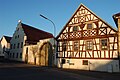
Half-timbered house


sons and daughters of the town
- Hans Döring (around 1483–1558), painter
- Simon Stäblein (* 1987), comedian and presenter
Web links
- [= http://www.heustreu.rhoen-saale.net local government]
- Heustreu: Official statistics of the LfStat
- Parish of St. Michael, Heustreu - history
Individual evidence
- ↑ "Data 2" sheet, Statistical Report A1200C 202041 Population of the municipalities, districts and administrative districts 1st quarter 2020 (population based on the 2011 census) ( help ).
- ↑ http://www.bayerische-landesbibliothek-online.de/orte/ortssuche_action.html ? Anzeige=voll&modus=automat&tempus=+20111120/222150&attr=OBJ&val= 1596
- ↑ a b Wolf-Armin von Reitzenstein : Lexicon of Franconian place names. Origin and meaning . Upper Franconia, Middle Franconia, Lower Franconia. CH Beck, Munich 2009, ISBN 978-3-406-59131-0 , p. 102 ( limited preview in Google Book search).
- ↑ Mayor. Heustreu municipality, accessed on August 17, 2020 .
- ^ Members of the parish council
- ^ Entry on the coat of arms of Heustreu in the database of the House of Bavarian History
- ↑ facilities

Aubstadt | Bad Königshofen im Grabfeld | Bad Neustadt an der Saale | Bastheim | Bischofsheim in the Rhön | Burglauer | Fladungen | Großbardorf | Großeibstadt | Hausen | Hendungen | Herbstadt | Haystack | Höchheim | Hohenroth | Hollstadt | Mellrichstadt | Niederlauer | Nordheim before the Rhön | Oberelsbach | Top litter | Ostheim before the Rhön | Rödelmaier | Hall on the Saale | Salt | Sandberg | Schönau an der Brend | Sondheim before the Rhön | Stockheim | Radiations | Sulzdorf an der Lederhecke | Sulzfeld | Trappstadt | Unsleben | Willmars | Wollbach | Wülfershausen on the Saale
Unregulated areas in the district of Rhön-Grabfeld Bundorfer Forst |
Burgwallbach Forest |
Forest Schmalwasser-Nord |
Forest Schmalwasser-Süd |
Mellrichstadter Forest |
Steinacher Forest on the right of the Saale |
Sulzfelder Forest |
Weigler