
Niederlauer
| coat of arms | Germany map | |
|---|---|---|

|
Coordinates: 50 ° 18 ' N , 10 ° 11' E |
|
| Basic data | ||
| State : | Bavaria | |
| Administrative region : | Lower Franconia | |
| County : | Rhön-Grabfeld | |
| Management Community : | Bad Neustadt an der Saale | |
| Height : | 242 m above sea level NHN | |
| Area : | 9.08 km 2 | |
| Residents: | 1683 (Dec. 31, 2019) | |
| Population density : | 185 inhabitants per km 2 | |
| Postal code : | 97618 | |
| Area code : | 09771 | |
| License plate : | NES, CAN, MET | |
| Community key : | 09 6 73 146 | |
| LOCODE : | DE NU4 | |
| Community structure: | 4 districts | |
| Association administration address: | Goethestr. 1 97616 Bad Neustadt adSaale |
|
| Website : | ||
| Mayor : | Richard Knaier ( Free Association of Voters ) | |
| Location of the municipality of Niederlauer in the Rhön-Grabfeld district | ||
  |
||

Niederlauer is a municipality in the Lower Franconian district of Rhön-Grabfeld and a member of the Bad Neustadt an der Saale administrative community .
geography
Niederlauer is located in the Main-Rhön region . The Franconian Saale and the Lauer , which unite here, flow through the municipality .
Community structure
Niederlauer is divided into four districts:
- Niederlauer
- Oberebersbach
- Unterebersbach
- Meadow mill
There are the districts Niederlauer, Oberebersbach and Unterebersbach .
history
Until the church is planted
The place in the office Neustadt an der Saale of the Hochstift Würzburg belonged to the Franconian Empire from 1500 . After secularization in 1803 in favor of Bavaria, it was given to Archduke Ferdinand of Tuscany in 1805 to form the Grand Duchy of Würzburg and with this in 1814 it finally fell to Bavaria . In the course of the administrative reforms in Bavaria, today's municipality was created with the municipal edict of 1818 .
Incorporations
On January 1, 1978, the previously independent communities Oberebersbach and Unterebersbach were incorporated.
Population development
- 1961: 1045 inhabitants
- 1970: 1086 inhabitants
- 1987: 1333 inhabitants
- 1991: 1521 inhabitants
- 1995: 1808 inhabitants
- 2000: 1863 inhabitants
- 2005: 1803 inhabitants
- 2010: 1742 inhabitants
- 2011: 1694 inhabitants
- 2012: 1699 inhabitants
- 2013: 1651 inhabitants
- 2014: 1668 inhabitants
- 2015: 1664 inhabitants
politics
Richard Knaier (Free Association of Voters) has been mayor since 1995.
Culture and sights
Niederlauer has a historic town center with some listed buildings. The Catholic Church of St. Catherine was built in 1888. Opposite it is the cemetery on the road to Oberebersbach.
Born in Niederlauer and raised sculptor Jimmy Fell , the community donated three sculptures: the west gate with four original parts of the Berlin Wall , the shrine (Madonna and Child in a blue gate) and the catcher of the sun .
Architectural monuments
Soil monuments
Economy and Infrastructure
Economy including agriculture and forestry
Niederlauer is still dominated by agriculture, which is illustrated by the 25 local farms. 51% of the district area is used for agriculture. However, the industrial area in the east of the municipality also testifies to the strong growth of the manufacturing industry. The most important companies here are the companies RST Stahlbau and Ganshorn Medizin Electronic with over 150 employees.
education
There are the following institutions (as of 2018):
- two day-care centers with a total of 115 places and 76 children
Personalities
- Jimmy Fell (* 1956), artist and engineer

Blue Gate 1 - West Gate, Berlin Wall (J. Fell)
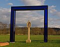
Blue Gate 2 - Madonna in Blue Gate (J. Fell)

"Catcher of the Sun" - football (J. Fell)

.jpg)
.jpg)
.JPG)
Web links
- Entry on Niederlauer's coat of arms in the database of the House of Bavarian History
Individual evidence
- ↑ "Data 2" sheet, Statistical Report A1200C 202041 Population of the municipalities, districts and administrative districts 1st quarter 2020 (population based on the 2011 census) ( help ).
- ↑ http://www.bayerische-landesbibliothek-online.de/orte/ortssuche_action.html ? Anzeige=voll&modus=automat&tempus=+20111120/231736&attr=OBJ&val= 1602
- ↑ a b c Federal Statistical Office (ed.): Historical municipality directory for the Federal Republic of Germany. Name, border and key number changes in municipalities, counties and administrative districts from May 27, 1970 to December 31, 1982 . W. Kohlhammer GmbH, Stuttgart / Mainz 1983, ISBN 3-17-003263-1 , p. 741 .

Aubstadt | Bad Königshofen im Grabfeld | Bad Neustadt an der Saale | Bastheim | Bischofsheim in the Rhön | Burglauer | Fladungen | Großbardorf | Großeibstadt | Hausen | Hendungen | Herbstadt | Haystack | Höchheim | Hohenroth | Hollstadt | Mellrichstadt | Niederlauer | Nordheim before the Rhön | Oberelsbach | Top litter | Ostheim before the Rhön | Rödelmaier | Hall on the Saale | Salt | Sandberg | Schönau an der Brend | Sondheim before the Rhön | Stockheim | Radiations | Sulzdorf an der Lederhecke | Sulzfeld | Trappstadt | Unsleben | Willmars | Wollbach | Wülfershausen on the Saale
Unregulated areas in the district of Rhön-Grabfeld Bundorfer Forst |
Burgwallbach Forest |
Forest Schmalwasser-Nord |
Forest Schmalwasser-Süd |
Mellrichstadter Forest |
Steinacher Forest on the right of the Saale |
Sulzfelder Forest |
Weigler