
Autumn city
| coat of arms | Germany map | |
|---|---|---|

|
Coordinates: 50 ° 20 ′ N , 10 ° 30 ′ E |
|
| Basic data | ||
| State : | Bavaria | |
| Administrative region : | Lower Franconia | |
| County : | Rhön-Grabfeld | |
| Management Community : | Bad Königshofen in Grabfeld | |
| Height : | 308 m above sea level NHN | |
| Area : | 20.7 km 2 | |
| Residents: | 583 (Dec. 31, 2019) | |
| Population density : | 28 inhabitants per km 2 | |
| Postal code : | 97633 | |
| Area code : | 09761 | |
| License plate : | NES, CAN, MET | |
| Community key : | 09 6 73 131 | |
| Community structure: | 4 districts | |
| Association administration address: | Josef-Sperl-Str. 3 97631 Bad Königshofen i.Grabfeld |
|
| Website : | ||
| Mayor : | Georg Rath ( CSU / Wgr. Breitensee / Wgr.Ottelm.) | |
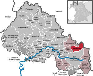
| Location of the municipality of Herbstadt in the Rhön-Grabfeld district | ||
  |
||

Herbstadt is a municipality and a village in the Lower Franconian district of Rhön-Grabfeld .
geography
location
The community is located in the Main-Rhön region .
Community structure
There are four districts:
- Breitensee
- Dörfleshof
- Autumn city
- Ottelmannshausen
There are the districts Breitensee, Herbstadt and Ottelmannshausen.
history
Until the church is planted
From the end of the 8th century, the lands in the area of today's Herbstadt belonged to the Fulda monastery . From the middle of the 13th century, Herbstadt was part of the county of Henneberg (from 1245 under the care of Coburg , from 1317 under the office of Heldburg). In 1354, Herbstadt came to the Würzburg Monastery ( Koenigshofen Office ) after two divisions of the Henneberg-Schleusingen line . From 1500 the place was in the Franconian Empire .
In 1803 Herbstadt was secularized in favor of Bavaria, then in the Peace of Pressburg in 1805 Archduke Ferdinand of Tuscany was left to form the Grand Duchy of Würzburg , with which it finally fell to Bavaria in 1814 . In the course of the administrative reforms in Bavaria, today's municipality was created with the municipal edict of 1818 .
Incorporations
On January 1, 1978, the previously independent communities Breitensee and Ottelmannshausen were incorporated.
Population development
- 1961: 929 inhabitants
- 1970: 862 inhabitants
- 1987: 676 inhabitants
- 1991: 719 inhabitants
- 1995: 747 inhabitants
- 2000: 708 inhabitants
- 2005: 662 inhabitants
- 2010: 646 inhabitants
- 2015: 619 inhabitants
The community is a member of the Bad Königshofen administrative community in Grabfeld .
mayor
The first mayor is Georg Rath (CSU / Breitensee voter group / Ottelmann group) and the second mayor Burkhard Bähr (Breitensee voter group).
coat of arms
|
|
Blazon : "Split of gold and blue, in the base of the shield covered with a small plate split with four points of red and silver, in front a floating black paw cross, behind a silver sloping bar which is covered with three blue rings." |
Municipal alliance
The municipality of Herbstadt is a member of the municipal alliance Fränkischer Grabfeldgau .
Culture and sights
Architectural monuments
Soil monuments
Natural monuments

- There is a winter linden tree on the outskirts . It is registered as a natural monument with the Lower Nature Conservation Authority of the Rhön-Grabfeld district. In 2011 the trunk had a circumference of 6.10 meters at the point of its smallest diameter and a height of 7.50 meters.
- To the north of Herbstadt lies the 212 hectare "Poppenholz" nature reserve, which was created not least because of its peripheral location on the former inner-German border .
- On the linden hill in Herbstadt there are several interesting buildings (church, rectory, town hall and tavern) that were built under Prince-Bishop Julius Echter .
- Dörfleshof
Biking and hiking trails
- The Celtic Adventure Trail runs through the community .
Economy and Infrastructure
Economy including agriculture and forestry
In 1998, according to official statistics in the manufacturing industry and in the trade and transport sector, there were no employees at work subject to social security contributions. There were a total of 180 employees at the place of residence subject to social insurance contributions. There were four companies in the manufacturing sector and one in the construction sector. In addition, in 1999 there were 51 farms with an agricultural area of 2093 hectares, of which 1876 hectares were arable land and 213 hectares were permanent green space.
education
The following institutions exist (as of 2013):
- Day care center
Sons and daughters of the church
- Ludwig Karl Reichert (1840–1909), farmer and member of the German Reichstag
- Theophil Steinbrenner (1946–2018), visual artist
Web links
Individual evidence
- ↑ "Data 2" sheet, Statistical Report A1200C 202041 Population of the municipalities, districts and administrative districts 1st quarter 2020 (population based on the 2011 census) ( help ).
- ↑ http://www.bayerische-landesbibliothek-online.de/orte/ortssuche_action.html ? Anzeige=voll&modus=automat&tempus=+20111120/221116&attr=OBJ&val= 1595
- ↑ a b c Federal Statistical Office (ed.): Historical municipality directory for the Federal Republic of Germany. Name, border and key number changes in municipalities, counties and administrative districts from May 27, 1970 to December 31, 1982 . W. Kohlhammer GmbH, Stuttgart / Mainz 1983, ISBN 3-17-003263-1 , p. 740 .
- ↑ Mayor. Herbstadt municipality, accessed on August 15, 2020 .
- ^ Entry on the coat of arms of Herbstadt in the database of the House of Bavarian History

Aubstadt | Bad Königshofen im Grabfeld | Bad Neustadt an der Saale | Bastheim | Bischofsheim in the Rhön | Burglauer | Fladungen | Großbardorf | Großeibstadt | Hausen | Hendungen | Herbstadt | Haystack | Höchheim | Hohenroth | Hollstadt | Mellrichstadt | Niederlauer | Nordheim before the Rhön | Oberelsbach | Top litter | Ostheim before the Rhön | Rödelmaier | Hall on the Saale | Salt | Sandberg | Schönau an der Brend | Sondheim before the Rhön | Stockheim | Radiations | Sulzdorf an der Lederhecke | Sulzfeld | Trappstadt | Unsleben | Willmars | Wollbach | Wülfershausen on the Saale
Unregulated areas in the district of Rhön-Grabfeld Bundorfer Forst |
Burgwallbach Forest |
Forest Schmalwasser-Nord |
Forest Schmalwasser-Süd |
Mellrichstadter Forest |
Steinacher Forest on the right of the Saale |
Sulzfelder Forest |
Weigler