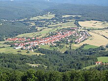
Sandberg
| coat of arms | Germany map | |
|---|---|---|

|
Coordinates: 50 ° 21 ' N , 10 ° 0' E |
|
| Basic data | ||
| State : | Bavaria | |
| Administrative region : | Lower Franconia | |
| County : | Rhön-Grabfeld | |
| Height : | 490 m above sea level NHN | |
| Area : | 28.03 km 2 | |
| Residents: | 2391 (Dec. 31, 2019) | |
| Population density : | 85 inhabitants per km 2 | |
| Postal code : | 97657 | |
| Area code : | 09701 | |
| License plate : | NES, CAN, MET | |
| Community key : | 09 6 73 162 | |
| Community structure: | 5 parts of the community | |
| Address of the municipal administration: |
Schulstrasse 6 97657 Sandberg |
|
| Website : | ||
| Mayor : | Sonja Reubelt | |
| Location of the municipality of Sandberg in the Rhön-Grabfeld district | ||

Sandberg is a municipality in the Lower Franconian district of Rhön-Grabfeld .
geography
Sandberg is located in the Main-Rhön region .
Community structure
The large community of Sandberg is divided into five parts: Sandberg, Kilianshof , Schmalwasser , Waldberg , Langenleiten .
history
Until the church is planted
Sandberg was not created until 1691 when settlers cleared the overpopulated Schmalwasser. The former office of the Hochstift Würzburg belonged to the Franconian Empire from 1500 . After secularization in Bavaria in 1803, it was given to Archduke Ferdinand of Tuscany in 1805 to form the Grand Duchy of Würzburg and with this in 1814 it finally fell to Bavaria. In the course of the administrative reforms, the current community was created with the community edict of 1818.
Incorporations
During the regional reform in Bavaria , the municipalities of Langenleiten, Schmalwasser and Waldberg were incorporated on January 1, 1972.
Population development
- 1961: 2589 inhabitants
- 1970: 2761 inhabitants
- 1987: 2798 inhabitants
- 1991: 2896 inhabitants
- 1995: 2960 inhabitants
- 2000: 2922 inhabitants
- 2005: 2865 inhabitants
- 2010: 2635 inhabitants
- 2015: 2506 inhabitants
- 2019: 2477 inhabitants
politics
Mayor Sonja Reubelt was elected to office in 2017.
Former mayors:
- Benno Katzenberger: 1972–1984
- Bruno Regnat: 1984–2000 († 2000)
- Detlef Beinhauer: 2001–2014
- Joachim Bühner: 2014–2016
- Roland Bühner: 2016–2017
Architectural monuments
Economy and Infrastructure
In 1998, according to official statistics, there were 75 employees at the place of work in the manufacturing sector and 21 in the trade and transport sector. In other economic sectors 49 people were employed at the place of work subject to social security contributions. There were a total of 998 employees at the place of residence subject to social insurance contributions. There were four companies in the manufacturing sector and two in the construction sector. In addition, in 1999 there were 100 farms with an agricultural area of 793 hectares, of which 208 hectares were arable land and 570 hectares were permanent green space.
education
There are the following institutions (as of 2019):
- 4 kindergartens (Sandberg, Schmalwasser, Waldberg, Langenleiten)
- Sandberg elementary school, grades 1–4
- Montessori School Rhön-Saale, grades 1–9
Tourism and leisure
- Sandberg wood carving pavilion with tourist information point, Schulstrasse 1. Opening times daily, April – October 9 am–5pm, November – March 10 am–4pm
- Kunstanger Langenleiten: Permanent exhibition of works of art by local artists on the village green
- Nature experience path on the Kreuzberg: The approx. 3.5 km long circular path with access at the Sandberg hiking car park extends along the Kreuzberg tour / K-Weg extra tour on the southern slope of the Kreuzberg. The nature experience and nature trail contains tree, bird and natural history boards from the nature trail from the 1990s, a new insect nesting house, many new interactive stations (tree telephone, long jump facility, dendrophone, forest memory, bird watching house, etc.) as well as benches and a wave lounger for a view beyond South.
literature
- Rhön Biosphere Reserve Bavarian Administration Office (Hrsg.): Historical cultural landscape of the forest villages - Sandberg, Waldberg, Langenleiten, Schmalwasser and Kilianshof. (= Rhön historical cultural landscape. Volume 2). Michael Imhof Verlag, Petersberg 2009, ISBN 978-3-86568-557-5 .
- Johann Pfeufer: Rhönerisch and Franconian. A comparative folklore. 2nd Edition. Publishing house Michael Laßleben, Kallmünz 1972.
Web links
- Official website of the municipality of Sandberg
- Tourist information for the municipality of Sandberg
- Sandberg community at Rhoenfuehrer.de
- Sandberg community at Kreuzbergallianz.de
- ARGE Büttner Röhrer: At home in the forest villages - preserving and developing home (PDF)
- Sandberg: Official statistics of the LfStat
- Entry on Sandberg's coat of arms in the database of the House of Bavarian History
Individual evidence
- ↑ "Data 2" sheet, Statistical Report A1200C 202041 Population of the municipalities, districts and administrative districts 1st quarter 2020 (population based on the 2011 census) ( help ).
- ^ 1. Mayoress of the community Sandberg
- ^ Wilhelm Volkert (ed.): Handbook of Bavarian offices, communities and courts 1799–1980 . CH Beck, Munich 1983, ISBN 3-406-09669-7 , p. 428 .
- ↑ http://www.mainpost.de/regional/franken/Rathauschef-zerbrach-offenbar-am-Wasserstreit;art1727,1023984
- ↑ Nature adventure trail on the Kreuzberg. In: Die-Rhoener-Walddoerfer.de. Retrieved June 6, 2020 .
- ↑ Extra tour Kreuzberg tour. In: Rhoen.de. Retrieved June 6, 2020 .


