
Wollbach (Lower Franconia)
| coat of arms | Germany map | |
|---|---|---|

|
Coordinates: 50 ° 22 ' N , 10 ° 13' E |
|
| Basic data | ||
| State : | Bavaria | |
| Administrative region : | Lower Franconia | |
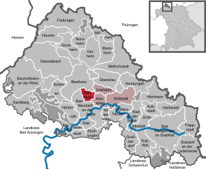
| County : | Rhön-Grabfeld | |
| Management Community : | Haystack | |
| Height : | 266 m above sea level NHN | |
| Area : | 7.58 km 2 | |
| Residents: | 1361 (Dec. 31, 2019) | |
| Population density : | 180 inhabitants per km 2 | |
| Postal code : | 97618 | |
| Area code : | 09773 | |
| License plate : | NES, CAN, MET | |
| Community key : | 09 6 73 183 | |
| Community structure: | 1 district | |
| Address of the municipal administration: |
Kirchstrasse 2 97618 Wollbach |
|
| Website : | ||
| Mayor : | Thomas Bruckmüller ( CSU ) | |
| Location of the municipality of Wollbach in the Rhön-Grabfeld district | ||
  |
||

Wollbach is a municipality in the Lower Franconian district of Rhön-Grabfeld and a member of the Heustreu administrative community .
geography
Wollbach is located in the Main-Rhön region, 4.5 km north of Bad Neustadt . Only the Wollbach area exists .
history
Until the church is planted
The Cistercian monastery in Bildhausen owned the patronage rights of the church as well as goods and income in Wollbach. The office of the Hochstift Würzburg belonged to the Franconian Empire from 1500 . After secularization in 1803 in favor of Bavaria, it was given to Archduke Ferdinand of Tuscany in 1805 to form the Grand Duchy of Würzburg and with this in 1814 it finally fell to Bavaria . In the course of the administrative reforms, the current community was created with the community edict of 1818 .
Population development
Population development in the municipality of Wollbach:
| year | 1970 | 1987 | 1991 | 1995 | 2000 | 2005 | 2010 | 2015 |
| Residents | 1011 | 1146 | 1201 | 1262 | 1359 | 1260 | 1299 | 1298 |
politics
Alois Gensler was mayor (CSU / Bürgerblock) from 2002 to 2014. He was the successor to Karl Fiedler (CSU / Bürgerblock). Thomas Bruckmüller has been Alois Gensler's successor since May 2014.
In the 2020 local elections, the CSU / Citizens' Block list received eight seats, the Wollbacher voter community four seats in the local council.
Economy and Infrastructure
Economy including agriculture and forestry
According to official statistics, there were 57 employees at the place of work in the manufacturing sector and 49 in the trade and transport sector. In other economic areas, 28 people were employed at the place of work subject to social security contributions. There were a total of 499 employees at the place of residence subject to social security contributions. There were none in the manufacturing sector and two in the construction sector. In addition, in 1999 there were ten agricultural holdings with an agriculturally used area of 397 ha, of which 351 ha were arable land. The well-known pipe maker Anton Manger has been running his tobacco pipe factory in Wollbach since 1957.
education
There are the following institutions (as of 2018):
- Kindergartens: 60 kindergarten places with 44 children
Buildings
- Village church with steeple with a long high peak ( Julius-Echter-Spitze )
- "Wollhalla" assembly hall
Others
South of Wollbach on the road to Heustreu is the abandoned Camp Lee base of the 2nd Squadron of the 11th Armored Cavalry Regiment of the US armed forces. This base was built in the late 1940s and expanded in the 1970s. In 1992 he was given up. From 1992 to 1996 it served as a home for asylum seekers, later it served as a courier service as accommodation. Today the facility is orphaned.
The Wollbachers are also known as "sand bunnies" in the region. The background to this are the sand pits, which are located south of the village and were still operated commercially until the 1980s.

Town View (2011)
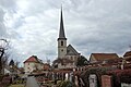
Parish Church of St. Boniface

Town View (2011)

School (2011)


Web links
- Pictures of the abandoned Camp Lee base
- Entry on the coat of arms of Wollbach (Lower Franconia) in the database of the House of Bavarian History
Individual evidence
- ↑ "Data 2" sheet, Statistical Report A1200C 202041 Population of the municipalities, districts and administrative districts 1st quarter 2020 (population based on the 2011 census) ( help ).

Aubstadt | Bad Königshofen im Grabfeld | Bad Neustadt an der Saale | Bastheim | Bischofsheim in the Rhön | Burglauer | Fladungen | Großbardorf | Großeibstadt | Hausen | Hendungen | Herbstadt | Haystack | Höchheim | Hohenroth | Hollstadt | Mellrichstadt | Niederlauer | Nordheim before the Rhön | Oberelsbach | Top litter | Ostheim before the Rhön | Rödelmaier | Hall on the Saale | Salt | Sandberg | Schönau an der Brend | Sondheim before the Rhön | Stockheim | Radiations | Sulzdorf an der Lederhecke | Sulzfeld | Trappstadt | Unsleben | Willmars | Wollbach | Wülfershausen on the Saale
Unregulated areas in the district of Rhön-Grabfeld Bundorfer Forst |
Burgwallbach Forest |
Forest Schmalwasser-Nord |
Forest Schmalwasser-Süd |
Mellrichstadter Forest |
Steinacher Forest on the right of the Saale |
Sulzfelder Forest |
Weigler